

U.S. Route 89 in Arizona
Encyclopedia

U.S. state
A U.S. state is any one of the 50 federated states of the United States of America that share sovereignty with the federal government. Because of this shared sovereignty, an American is a citizen both of the federal entity and of his or her state of domicile. Four states use the official title of...
of Arizona
Arizona
Arizona ; is a state located in the southwestern region of the United States. It is also part of the western United States and the mountain west. The capital and largest city is Phoenix...
, U.S. Route 89
U.S. Route 89
U.S. Route 89 is a north–south United States Highway with two sections, and one former section. The southern section runs for 848 miles from Flagstaff, Arizona, to the southern entrance of Yellowstone National Park...
is a U.S. Highway that begins in Flagstaff
Flagstaff, Arizona
Flagstaff is a city located in northern Arizona, in the southwestern United States. In 2010, the city's population was 65,870. The population of the Metropolitan Statistical Area was at 134,421 in 2010. It is the county seat of Coconino County...
and heads north to the Utah
Utah
Utah is a state in the Western United States. It was the 45th state to join the Union, on January 4, 1896. Approximately 80% of Utah's 2,763,885 people live along the Wasatch Front, centering on Salt Lake City. This leaves vast expanses of the state nearly uninhabited, making the population the...
border northwest of Page
Page, Arizona
Page is a city in Coconino County, Arizona, United States, near the Glen Canyon Dam and Lake Powell. According to 2005 Census Bureau estimates, the population of the city is 6,794.-Geography:Page is located at ....
.
Route description
U.S. 89 begins at Flagstaff, Arizona, the highway proceeds north passing near Grand Canyon National ParkGrand Canyon National Park
Grand Canyon National Park is the United States' 15th oldest national park and is located in Arizona. Within the park lies the Grand Canyon, a gorge of the Colorado River, considered to be one of the Wonders of the World. The park covers of unincorporated area in Coconino and Mohave counties.Most...
and through the Navajo Nation
Navajo Nation
The Navajo Nation is a semi-autonomous Native American-governed territory covering , occupying all of northeastern Arizona, the southeastern portion of Utah, and northwestern New Mexico...
. Near the Utah State Line the highway splits into U.S. 89 and U.S. 89A
U.S. Route 89A (Arizona)
U.S. Route 89A is a north–south auxiliary U.S. highway, though its actual direction of travel is more east–west. The highway is an old routing of U.S. Route 89 from Bitter Springs, Arizona to Kanab, Utah. The state of Arizona has designated this highway the Fredonia-Vermilion Cliffs...
. The Alternate is the original highway, what is now the main highway was constructed in the 1960s to serve the Glen Canyon Dam
Glen Canyon Dam
Glen Canyon Dam is a concrete arch dam on the Colorado River in northern Arizona in the United States, just north of Page. The dam was built to provide hydroelectricity and flow regulation from the upper Colorado River Basin to the lower. Its reservoir is called Lake Powell, and is the second...
. The two highways rejoin in Kanab, Utah
Kanab, Utah
Kanab is a city in and the county seat of Kane County, Utah, United States. The area was first settled in 1864 and the town was founded in 1870 when ten Mormon families moved into the area. The population was 3,564 at the 2000 census...
.
The main branch passes over the Colorado River
Colorado River
The Colorado River , is a river in the Southwestern United States and northwestern Mexico, approximately long, draining a part of the arid regions on the western slope of the Rocky Mountains. The watershed of the Colorado River covers in parts of seven U.S. states and two Mexican states...
just south of the Glen Canyon Dam and Lake Powell
Lake Powell
Lake Powell is a huge reservoir on the Colorado River, straddling the border between Utah and Arizona . It is the second largest man-made reservoir in the United States behind Lake Mead, storing of water when full...
near Page
Page, Arizona
Page is a city in Coconino County, Arizona, United States, near the Glen Canyon Dam and Lake Powell. According to 2005 Census Bureau estimates, the population of the city is 6,794.-Geography:Page is located at ....
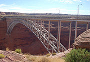
then enters Utah. The Alternate branch crosses the Colorado River at Navajo Bridge
Navajo Bridge
Navajo Bridge crosses the Colorado River's Marble Canyon near Lee's Ferry in the US state of Arizona. Apart from the Glen Canyon Bridge a few miles upstream at Page, Arizona, it is the only roadway crossing of the river and the Grand Canyon for nearly...
and proceeds to the North Rim of the Grand Canyon before entering Utah.
History
Prior to 1992, the southern terminus of U.S. 89 was at Nogales, ArizonaNogales, Arizona
Nogales is a city in Santa Cruz County, Arizona, United States. The population was 21,017 at the 2010 census. According to 2005 Census Bureau estimates, the population of the city is 20,833. The city is the county seat of Santa Cruz County....
. U.S. 89 ran concurrently with Interstate 19 until Green Valley where it proceeded north along what is now Interstate 19 Business. The route was taken (in a northerly direction) through Tucson via 6th Avenue, Congress Street and Granada Avenue. The route was carried out of Tucson via State Route 77. Further north it was carried via the Pinal Pioneer Parkway northwest out of Oracle Junction on State Route 79. In Maricopa County, it ran concurrently with existing U.S. Route 60 along Main Street in Mesa
Mesa, Arizona
According to the 2010 Census, the racial composition of Mesa was as follows:* White: 77.1% * Hispanic or Latino : 26.54%* Black or African American: 3.5%* Two or more races: 3.4%* Native American: 2.4%...
, Apache Boulevard and Mill Avenue in Tempe
Tempe, Arizona
Tempe is a city in Maricopa County, Arizona, USA, with the Census Bureau reporting a 2010 population of 161,719. The city is named after the Vale of Tempe in Greece. Tempe is located in the East Valley section of metropolitan Phoenix; it is bordered by Phoenix and Guadalupe on the west, Scottsdale...
, then along Van Buren Street in Phoenix
Phoenix, Arizona
Phoenix is the capital, and largest city, of the U.S. state of Arizona, as well as the sixth most populated city in the United States. Phoenix is home to 1,445,632 people according to the official 2010 U.S. Census Bureau data...
to Grand Avenue, then to Wickenburg. Departing Wickenburg, it followed U.S. Route 93 and State Route 89 to Prescott
Prescott, Arizona
Prescott is a city in Yavapai County, Arizona, USA. It was designated "Arizona's Christmas City" by Arizona Governor Rose Mofford in the late 1980s....
. Departing Prescott, the route followed State Route 89A.
The alignment nears Interstate 17 at the Flagstaff Pulliam Airport
Flagstaff Pulliam Airport
Flagstaff Pulliam Airport is a city-owned public-use airport located four nautical miles south of the central business district of Flagstaff, a city in Coconino County, Arizona, United States...
but never ran concurrently with Interstate 17 as Interstate 17 replaced it. The interstate 17 - Interstate 40 improvements removed evidence of the original U.S. 89.
In Flagstaff, Arizona
Flagstaff, Arizona
Flagstaff is a city located in northern Arizona, in the southwestern United States. In 2010, the city's population was 65,870. The population of the Metropolitan Statistical Area was at 134,421 in 2010. It is the county seat of Coconino County...
, U.S. 89 ran along Milton Road and Santa Fe Avenue.
Junction list
The entire route is in Coconino CountyCoconino County, Arizona
-2010:Whereas according to the 2010 U.S. Census Bureau:*61.7% White*1.2% Black*27.3% Native American*1.4% Asian*0.1% Native Hawaiian or Pacific Islander*3.1% Two or more races*5.2% Other races*13.5% Hispanic or Latino -2000:...
.
| Location | Mile | Destinations | Notes |
|---|---|---|---|
| Flagstaff Flagstaff, Arizona Flagstaff is a city located in northern Arizona, in the southwestern United States. In 2010, the city's population was 65,870. The population of the Metropolitan Statistical Area was at 134,421 in 2010. It is the county seat of Coconino County... |
0.00 | , Albuquerque Albuquerque, New Mexico Albuquerque is the largest city in the state of New Mexico, United States. It is the county seat of Bernalillo County and is situated in the central part of the state, straddling the Rio Grande. The city population was 545,852 as of the 2010 Census and ranks as the 32nd-largest city in the U.S. As... |
|
| 46.76 | – Grand Canyon Grand Canyon The Grand Canyon is a steep-sided canyon carved by the Colorado River in the United States in the state of Arizona. It is largely contained within the Grand Canyon National Park, the 15th national park in the United States... |
||
| 62.32 | |||
| 105.13 | |||
| Page Page, Arizona Page is a city in Coconino County, Arizona, United States, near the Glen Canyon Dam and Lake Powell. According to 2005 Census Bureau estimates, the population of the city is 6,794.-Geography:Page is located at .... |
127.13 | ||
| 137.77 | Utah state line | ||