
.gif)
U.S. Route 89A (Arizona)
Encyclopedia
U.S. Route 89
U.S. Route 89 is a north–south United States Highway with two sections, and one former section. The southern section runs for 848 miles from Flagstaff, Arizona, to the southern entrance of Yellowstone National Park...
from Bitter Springs, Arizona
Bitter Springs, Arizona
Bitter Springs is a census-designated place in Coconino County, Arizona, in the United States. As of the 2000 census, the CDP population was 547.-Geography:Bitter Springs is located at ....
to Kanab, Utah
Kanab, Utah
Kanab is a city in and the county seat of Kane County, Utah, United States. The area was first settled in 1864 and the town was founded in 1870 when ten Mormon families moved into the area. The population was 3,564 at the 2000 census...
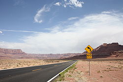
. The state of Arizona has designated this highway the Fredonia-Vermilion Cliffs Scenic Road. The highway is used to access Grand Canyon National Park
Grand Canyon National Park
Grand Canyon National Park is the United States' 15th oldest national park and is located in Arizona. Within the park lies the Grand Canyon, a gorge of the Colorado River, considered to be one of the Wonders of the World. The park covers of unincorporated area in Coconino and Mohave counties.Most...
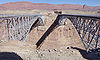
and is known for the Navajo Bridge
Navajo Bridge
Navajo Bridge crosses the Colorado River's Marble Canyon near Lee's Ferry in the US state of Arizona. Apart from the Glen Canyon Bridge a few miles upstream at Page, Arizona, it is the only roadway crossing of the river and the Grand Canyon for nearly...
. Until 2008, the Utah portion was signed State Route 11.
Route description
The highway's southern terminus is at U.S. Route 89 south of Page, ArizonaPage, Arizona
Page is a city in Coconino County, Arizona, United States, near the Glen Canyon Dam and Lake Powell. According to 2005 Census Bureau estimates, the population of the city is 6,794.-Geography:Page is located at ....
. Its northern terminus is in Kanab, Utah
Kanab, Utah
Kanab is a city in and the county seat of Kane County, Utah, United States. The area was first settled in 1864 and the town was founded in 1870 when ten Mormon families moved into the area. The population was 3,564 at the 2000 census...
, also as US 89. US 89A runs near or through Lee's Ferry
Lee's Ferry
Lee's Ferry is a site on the Colorado River in Coconino County, Arizona, United States, about 7.5 miles southwest of the town of Page, Arizona and the Glen Canyon Dam, and about 9 mi south of the Utah-Arizona border. It is the former location of a ferry established by John D. Lee, a Mormon...
, the Navajo Bridge
Navajo Bridge
Navajo Bridge crosses the Colorado River's Marble Canyon near Lee's Ferry in the US state of Arizona. Apart from the Glen Canyon Bridge a few miles upstream at Page, Arizona, it is the only roadway crossing of the river and the Grand Canyon for nearly...
, Vermilion Cliffs
Vermilion Cliffs
The Vermilion Cliffs are the second "step" up in the five-step Grand Staircase of the Colorado Plateau. Reddish or vermilion-colored cliffs are found along U.S. Highway 89 and U.S. Highway 89A near Kanab, Utah . They extend from a location near Page, Arizona, west for a considerable distance, in...
, the Kaibab Plateau
Kaibab Plateau
The Kaibab Plateau is located in northern Arizona in the United States. The plateau, part of the larger Colorado Plateau, is bordered on the south by the Grand Canyon and reaches an elevation of 9241 feet above sea level. The plateau is divided between Kaibab National Forest and the "North Rim"...
, and Fredonia, Arizona
Fredonia, Arizona
Fredonia is a town in Coconino County, Arizona, United States. Fredonia is Arizona's northernmost town and the gateway to the North Rim of the Grand Canyon. Visitors enjoy seeing the Grand Canyon from the North Rim because they can experience the wonder and beauty without large crowds and high...
. The eastern portion of the highway runs through part of the Navajo Nation
Navajo Nation
The Navajo Nation is a semi-autonomous Native American-governed territory covering , occupying all of northeastern Arizona, the southeastern portion of Utah, and northwestern New Mexico...
. From Jacob Lake, State Route 67 leads south to the North Rim of Grand Canyon National Park
Grand Canyon National Park
Grand Canyon National Park is the United States' 15th oldest national park and is located in Arizona. Within the park lies the Grand Canyon, a gorge of the Colorado River, considered to be one of the Wonders of the World. The park covers of unincorporated area in Coconino and Mohave counties.Most...
. Then north to the neighboring cities of Fredonia, Arizona
Fredonia, Arizona
Fredonia is a town in Coconino County, Arizona, United States. Fredonia is Arizona's northernmost town and the gateway to the North Rim of the Grand Canyon. Visitors enjoy seeing the Grand Canyon from the North Rim because they can experience the wonder and beauty without large crowds and high...
and Kanab, Utah
Kanab, Utah
Kanab is a city in and the county seat of Kane County, Utah, United States. The area was first settled in 1864 and the town was founded in 1870 when ten Mormon families moved into the area. The population was 3,564 at the 2000 census...
. The Utah portion of US 89A is defined by Utah Code Annotated §72-4-114.
History
This was part of mainline US 89 until the construction of Glen Canyon DamGlen Canyon Dam
Glen Canyon Dam is a concrete arch dam on the Colorado River in northern Arizona in the United States, just north of Page. The dam was built to provide hydroelectricity and flow regulation from the upper Colorado River Basin to the lower. Its reservoir is called Lake Powell, and is the second...
. In 1960, US 89 was moved to a new, more northerly route and the old route became US 89A.
The Utah segment of US 89A was first commissioned State Route 11. This highway ran from Nephi
Nephi, Utah
Nephi is a city in Juab County, Utah, United States. It is part of the Provo–Orem, Utah Metropolitan Statistical Area. The population was 4,733 at the 2000 census. It is the county seat of Juab County. It was settled by Mormon pioneers in 1851, and is the principal city in Juab Valley, an...
to the Arizona
Arizona
Arizona ; is a state located in the southwestern region of the United States. It is also part of the western United States and the mountain west. The capital and largest city is Phoenix...
state line near Kanab. This route is still drivable as the modern US 89A, US 89, and SR-132
Utah State Route 132
State Route 132 is a state highway in the U.S. state of Utah. It connects US-6 in Lynndyl to US-89 at Pigeon Hollow Junction, crossing Interstate 15 in Nephi.-Route description:...
. With the establishment of the United States highway system in 1926, most of SR-11 was used for the routing of US 89 through southern Utah; the internal designation used by state agencies remained SR-11. In 1969, as part of a series of changes to state routes
State highways deleted by the Utah State Legislature in 1969
A number of minor state highways in the U.S. state of Utah were deleted by the State Legislature in 1969.-State Route 50:State Route 50 was originally a branch of SR-122, but was split off as its own route in 1935, running from Wattis southeast to SR-122 east of Hiawatha...
, the portion north of Sevier Junction (I-70
Interstate 70 in Utah
Interstate 70 is a mainline route of the Interstate Highway System in the United States connecting Utah and Maryland. The Utah section runs east–west for across the central part of the state. Richfield is the largest Utah city served by the freeway, which does not serve or connect any urban areas...
and US 89 near Joseph
Joseph, Utah
Joseph is a town in Sevier County, Utah, United States. The population was 269 at the 2000 census. The town was named for Joseph A. Young, a local leader of The Church of Jesus Christ of Latter-day Saints...
) was transferred to other routes, removing the only part of State Route 11 that was signed with the state designation. It is also during this time that that a new alignment for US 89 was constructed to serve the Glen Canyon Dam
Glen Canyon Dam
Glen Canyon Dam is a concrete arch dam on the Colorado River in northern Arizona in the United States, just north of Page. The dam was built to provide hydroelectricity and flow regulation from the upper Colorado River Basin to the lower. Its reservoir is called Lake Powell, and is the second...
, with SR-11 being now signed as US 89A south of Kanab and US 89 to the north. As part of the 1977 Utah state route renumbering
1977 Utah state route renumbering
In 1977, the Utah State Legislature changed its system of how state route numbers were used and assigned. Prior to 1977 Utah used a system where every U.S. Highway and Interstate Highway traversing the state was also assigned a different Utah state route number. This state route number was not...
to conform signage and legislative definitions, SR-11 was truncated to what is now signed US 89A. The route was signed SR-11, with "TO US 89A" at the northern terminus in Kanab and a "TO US 89" at the Arizona state line. In 2008, however, SR-11 was deleted after a bill in the Utah legislature was passed to restore U.S. Route 89A in Utah.
From 1941 to 1992, there was a discontinuous southern portion US 89A running from Flagstaff
Flagstaff, Arizona
Flagstaff is a city located in northern Arizona, in the southwestern United States. In 2010, the city's population was 65,870. The population of the Metropolitan Statistical Area was at 134,421 in 2010. It is the county seat of Coconino County...
to Prescott, Arizona
Prescott, Arizona
Prescott is a city in Yavapai County, Arizona, USA. It was designated "Arizona's Christmas City" by Arizona Governor Rose Mofford in the late 1980s....
, now designated Arizona State Route 89A.
Junction list
| County | Location | Mile | Junction | Notes |
|---|---|---|---|---|
| Coconino Coconino County, Arizona -2010:Whereas according to the 2010 U.S. Census Bureau:*61.7% White*1.2% Black*27.3% Native American*1.4% Asian*0.1% Native Hawaiian or Pacific Islander*3.1% Two or more races*5.2% Other races*13.5% Hispanic or Latino -2000:... |
Bitter Springs Bitter Springs, Arizona Bitter Springs is a census-designated place in Coconino County, Arizona, in the United States. As of the 2000 census, the CDP population was 547.-Geography:Bitter Springs is located at .... |
0.00 | Milepost 524 | |
| Jacob Lake Jacob Lake, Arizona Jacob Lake is a small unincorporated community on the Kaibab Plateau in Coconino County, Arizona, United States, at the junction of U.S. Route 89A and State Route 67... |
55.23 | – North Rim Grand Canyon National Park Grand Canyon National Park Grand Canyon National Park is the United States' 15th oldest national park and is located in Arizona. Within the park lies the Grand Canyon, a gorge of the Colorado River, considered to be one of the Wonders of the World. The park covers of unincorporated area in Coconino and Mohave counties.Most... |
Milepost 579 | |
| Fredonia Fredonia, Arizona Fredonia is a town in Coconino County, Arizona, United States. Fredonia is Arizona's northernmost town and the gateway to the North Rim of the Grand Canyon. Visitors enjoy seeing the Grand Canyon from the North Rim because they can experience the wonder and beauty without large crowds and high... |
85.07 | Milepost 609 | ||
| 88.88 | Arizona/Utah State Line | AZ Milepost 613/UT Milepost 0 | ||
| Kane Kane County, Utah As of the census of 2000, there were 6,046 people, 2,237 households, and 1,628 families residing in the county. The population density was 2 people per square mile . There were 3,767 housing units at an average density of 1 per square mile... |
Kanab Kanab, Utah Kanab is a city in and the county seat of Kane County, Utah, United States. The area was first settled in 1864 and the town was founded in 1870 when ten Mormon families moved into the area. The population was 3,564 at the 2000 census... |
|||
| 91.74 | , Page Page, Arizona Page is a city in Coconino County, Arizona, United States, near the Glen Canyon Dam and Lake Powell. According to 2005 Census Bureau estimates, the population of the city is 6,794.-Geography:Page is located at .... |
Milepost 2.945 | ||