

U.S. Route 550
Encyclopedia
U.S. Route 550 is a spur of U.S. Highway 50 that runs from Bernalillo, New Mexico
to Montrose, Colorado
in the western United States
. The section from Silverton
to Ouray
is frequently called the Million Dollar Highway.
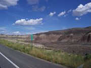 U.S. 550 begins just north of Albuquerque
at Bernalillo
and passes through the towns of San Ysidro
, Cuba
, Bloomfield
and Aztec
. All of Highway 550 in New Mexico has been upgraded to four lanes, offering a high-speed (70 mph) connection for Farmington, New Mexico
and Durango, Colorado
to Albuquerque
and Santa Fe
.
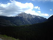 Most of U.S. 550 in Colorado is two-lane mountainous highway. It is one of only two north–south U.S. Highways in Colorado which runs west of the Continental Divide
The other route is US 491. The route travels north through the San Juan Mountains
.
The Million Dollar Highway stretches for about 25 miles (40.2 km) in western Colorado and follows the route of U.S. 550 between Silverton
and Ouray
, Colorado
. It is part of the San Juan Skyway Scenic Byway
. Between Durango and Silverton the Skyway loosely parallels the Durango and Silverton Narrow Gauge Railroad
.
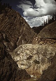
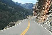 Though the entire stretch has been called the Million Dollar Highway, it is really the twelve miles (19 km) south of Ouray through the Uncompahgre Gorge
to the summit of Red Mountain Pass
which gains the highway its name. This stretch through the gorge is challenging and potentially hazardous to drive; it is characterized by steep cliffs, narrow lanes, and a lack of guardrails; the ascent of Red Mountain Pass is marked with a number of hairpin "S" curves used to gain elevation, and again, narrow lanes for traffic—many cut directly into the sides of mountains. During this ascent, the remains of the Idarado Mine
are visible. Travel north from Silverton to Ouray allows drivers to hug the inside of curves; travel south from Ouray to Silverton perches drivers on the vertiginous outside edge of the highway. Large RVs
travel in both directions, which adds a degree of excitement (or danger) to people in cars. The road is kept open year-round. Summer temperatures can range from 70-90 degree highs at the ends of the highway to 50-70 degrees in the mountain passes. The snow season starts in October, and snow will often close the road in winter. Chains may be required to drive.
North of Durango, the highway passes by Trimble Springs, hot springs that have been open for visitors since the late 19th century. The highway runs north along the Animas River
, under the Hermosa Cliffs. It enters the San Juan National Forest
and goes past Haviland Lake and Elektra Lake. Drivers pass by Engineer Mountain and Twilight Peak
before crossing Coal Bank Pass. Next is Molas Pass, which offers a panoramic view of Molas Lake, the Animas River Gorge, and Snowdon Peak. Northbound travelers then pass through the town of Silverton, elevation 9,320 feet (2841 m), surrounded by 13,000 foot (4000 m) peaks Sultan Mountain, Kendall Mountain
, and Storm Peak
.
The highway leaves Silverton and proceeds up Mineral Creek Valley before ascending to Red Mountain Pass. The ruins of the Longfellow Mine are visible along the way. The highway then goes through a series of steep grades and hairpin turns before reaching Lookout Point, which offers a view of the town of Ouray.
 This section of the route passes over three mountain pass
es:
The origin of the name Million Dollar Highway is disputed. There are several legends, though, including that it cost a million dollars a mile to build in the 1920s, and that its fill dirt contains a million dollars in gold ore.
U.S. 550 ends at the corner of Townsend Avenue and San Juan Avenue in Montrose, Colorado
at the junction of its parent route U.S. Highway 50.
 The original portion of the Million Dollar Highway was a toll road
built by Otto Mears
in 1883 to connect
Ouray
and Ironton
.
Another toll road was built over Red Mountain Pass
from Ironton
to Silverton
.
In the late 1880's Otto Mears
turned to building railroads and built the Silverton Railroad
north from
Silverton
over Red Mountain Pass
to reach the lucrative mining districts around
Red Mountain, terminating at Albany just eight miles (13 km) south of Ouray
.
The remaining eight miles (13 km) were considered too difficult and steep for a railroad.
At one point a cog railroad
was proposed, but it never made it beyond the planning stage.
In the early 1920's, the original toll road
was rebuilt at considerable cost and became the present day US 550. The Million Dollar Highway was completed in 1924.
Today the entire route is part of the San Juan Skyway Scenic Byway
.
Highway 550 was part of the original 1926 federal highway system. The original highway extended 110 miles (177 km) from Montrose, Colorado
at U.S. Highway 50 to U.S. Highway 450 (now U.S. Highway 160) at Durango, Colorado
. In 1934, Highway 550 was extended through Farmington
to Shiprock
, New Mexico
. In 1989, the western end of Highway 550 was replaced with U.S. Highway 64 between Farmington
and Shiprock
. In 1999, Highway 550 was rerouted at Aztec, New Mexico
to replace New Mexico State Highway 44 to Bernalillo, New Mexico
, at which time all of Highway 550 in New Mexico
was upgraded to four lanes.
In 2009 U.S. 50 was re-routed onto the San Juan Avenue bypass to avoid downtown Montrose. As a result, U.S. 550 was extended approximately one mile Northwest to intersect with the new U.S. 50 alignment.
Bernalillo, New Mexico
Bernalillo is a town in Sandoval County, New Mexico, in the United States. As of the 2000 census, the town population was 6,611. It is the county seat of Sandoval County.Bernalillo is part of the Albuquerque Metropolitan Statistical Area.-Geography:...
to Montrose, Colorado
Montrose, Colorado
The City of Montrose is a Home Rule Municipality that is the county seat and the most populous city of Montrose County, Colorado, United States. The United States Census Bureau estimates that the city population was 15,479 in 2005. The main road that leads in and out of Montrose is U.S...
in the western United States
United States
The United States of America is a federal constitutional republic comprising fifty states and a federal district...
. The section from Silverton
Silverton, Colorado
The town of Silverton is a Statutory Town that is the county seat of, and the only incorporated municipality in, San Juan County, Colorado, United States. Silverton is a former silver mining camp, most or all of which is now included in a federally designated National Historic Landmark District,...
to Ouray
Ouray, Colorado
The historic City of Ouray is a Home Rule Municipality that is the county seat and the most populous city of Ouray County, Colorado, United States. The city population was 813 at the U.S. Census 2000 and 1,000 as of the U.S. Census 2010...
is frequently called the Million Dollar Highway.
New Mexico
Albuquerque, New Mexico
Albuquerque is the largest city in the state of New Mexico, United States. It is the county seat of Bernalillo County and is situated in the central part of the state, straddling the Rio Grande. The city population was 545,852 as of the 2010 Census and ranks as the 32nd-largest city in the U.S. As...
at Bernalillo
Bernalillo, New Mexico
Bernalillo is a town in Sandoval County, New Mexico, in the United States. As of the 2000 census, the town population was 6,611. It is the county seat of Sandoval County.Bernalillo is part of the Albuquerque Metropolitan Statistical Area.-Geography:...
and passes through the towns of San Ysidro
San Ysidro, New Mexico
San Ysidro is a village in Sandoval County, New Mexico, United States. The population was 238 at the 2000 census. It is part of the Albuquerque Metropolitan Statistical Area....
, Cuba
Cuba, New Mexico
Cuba is a village in Sandoval County, New Mexico, in the United States. As of the 2000 census, the village population was 590. It is part of the Albuquerque Metropolitan Statistical Area...
, Bloomfield
Bloomfield, New Mexico
Bloomfield is a city in San Juan County, New Mexico, United States. It is part of the Farmington Metropolitan Statistical Area. The population was 6,420 at the 2000 census.-Geography:Bloomfield is located at ....
and Aztec
Aztec, New Mexico
Aztec is a city in San Juan County, New Mexico, United States. It is part of the Farmington, New Mexico Metropolitan Statistical Area. The population was 6,378 at the 2000 census. It is the county seat of San Juan County...
. All of Highway 550 in New Mexico has been upgraded to four lanes, offering a high-speed (70 mph) connection for Farmington, New Mexico
Farmington, New Mexico
Farmington is a city in San Juan County in the U.S. state of New Mexico. As of the 2010 U.S. Census the city had a total population of 45,877 people. Farmington makes up one of the four Metropolitan Statistical Areas in New Mexico. The U.S...
and Durango, Colorado
Durango, Colorado
The City of Durango is a Home Rule Municipality that is the county seat and the most populous city of La Plata County, Colorado, United States. The United States Census Bureau said that the city population was 16,887 in 2010 census.-History:...
to Albuquerque
Albuquerque, New Mexico
Albuquerque is the largest city in the state of New Mexico, United States. It is the county seat of Bernalillo County and is situated in the central part of the state, straddling the Rio Grande. The city population was 545,852 as of the 2010 Census and ranks as the 32nd-largest city in the U.S. As...
and Santa Fe
Santa Fe, New Mexico
Santa Fe is the capital of the U.S. state of New Mexico. It is the fourth-largest city in the state and is the seat of . Santa Fe had a population of 67,947 in the 2010 census...
.
Colorado
Continental Divide
The Continental Divide of the Americas, or merely the Continental Gulf of Division or Great Divide, is the name given to the principal, and largely mountainous, hydrological divide of the Americas that separates the watersheds that drain into the Pacific Ocean from those river systems that drain...
The other route is US 491. The route travels north through the San Juan Mountains
San Juan Mountains
The San Juan Mountains are a high and rugged mountain range in the Rocky Mountains in southwestern Colorado. The area is highly mineralized and figured in the gold and silver mining industry of early Colorado. Major towns, all old mining camps, include Creede, Lake City, Silverton, Ouray, and...
.
The Million Dollar Highway stretches for about 25 miles (40.2 km) in western Colorado and follows the route of U.S. 550 between Silverton
Silverton, Colorado
The town of Silverton is a Statutory Town that is the county seat of, and the only incorporated municipality in, San Juan County, Colorado, United States. Silverton is a former silver mining camp, most or all of which is now included in a federally designated National Historic Landmark District,...
and Ouray
Ouray, Colorado
The historic City of Ouray is a Home Rule Municipality that is the county seat and the most populous city of Ouray County, Colorado, United States. The city population was 813 at the U.S. Census 2000 and 1,000 as of the U.S. Census 2010...
, Colorado
Colorado
Colorado is a U.S. state that encompasses much of the Rocky Mountains as well as the northeastern portion of the Colorado Plateau and the western edge of the Great Plains...
. It is part of the San Juan Skyway Scenic Byway
San Juan Skyway Scenic Byway
The San Juan Skyway is one of an All-American Road and a component in the Colorado Scenic and Historic Byway System. It forms a loop in the southwest part of the U.S. state of Colorado traversing the heart of the San Juan Mountains.- U.S. Highway 160 :...
. Between Durango and Silverton the Skyway loosely parallels the Durango and Silverton Narrow Gauge Railroad
Durango and Silverton Narrow Gauge Railroad
The Durango and Silverton Narrow Gauge Railroad is a narrow gauge heritage railroad that operates of track between Durango and Silverton, in the US state of Colorado...
.
Uncompahgre Gorge
The Uncompahgre Gorge is a deep mountain canyon formed by the Uncompahgre River and Red Mountain Creek just south of Ouray, Colorado. At the north end of the Gorge the Uncompahgre River flows into a deep box canyon which is home to Ouray Ice Park . Access to the gorge is via U.S. Highway 550...
to the summit of Red Mountain Pass
Red Mountain Pass
Red Mountain Pass elevation is a mountain pass in the San Juan Mountains of western Coloradoin the United States.The pass straddles a divide that separates Ouray and San Juan counties. The pass is named for the nearby Red Mountain 1, 2 and, 3 on the northeast side of the pass...
which gains the highway its name. This stretch through the gorge is challenging and potentially hazardous to drive; it is characterized by steep cliffs, narrow lanes, and a lack of guardrails; the ascent of Red Mountain Pass is marked with a number of hairpin "S" curves used to gain elevation, and again, narrow lanes for traffic—many cut directly into the sides of mountains. During this ascent, the remains of the Idarado Mine
Idarado Mine
The Idarado Mine was a gold mining operation in the San Juan Mountains of Ouray County, Colorado. The mine is within the Sneffels-Red Mountain-Telluride mining district. The remains of the operation are visible from the Million Dollar Highway, north of Red Mountain Pass, between Ouray and...
are visible. Travel north from Silverton to Ouray allows drivers to hug the inside of curves; travel south from Ouray to Silverton perches drivers on the vertiginous outside edge of the highway. Large RVs
Recreational vehicle
Recreational vehicle or RV is, in North America, the usual term for a Motor vehicle or trailer equipped with living space and amenities found in a home.-Features:...
travel in both directions, which adds a degree of excitement (or danger) to people in cars. The road is kept open year-round. Summer temperatures can range from 70-90 degree highs at the ends of the highway to 50-70 degrees in the mountain passes. The snow season starts in October, and snow will often close the road in winter. Chains may be required to drive.
North of Durango, the highway passes by Trimble Springs, hot springs that have been open for visitors since the late 19th century. The highway runs north along the Animas River
Animas River
Animas River is a river in the western United States, a tributary of the San Juan River, part of the Colorado River System. The Spanish named the river "Rio de las Animas Perdidas", "River of the Lost Souls". It is also the last free-flowing river in Colorado. The river's free-flowing status...
, under the Hermosa Cliffs. It enters the San Juan National Forest
San Juan National Forest
The San Juan National Forest is a U.S. National Forest covering over 1,878,846 acres in Archuleta, Conjeos, Dolores, Hinsdale, La Plata, Mineral, Montezuma, Rio Grande, San Miguel and San Juan Counties in western Colorado. It borders the Uncompahgre National Forest to the north and the Rio Grande...
and goes past Haviland Lake and Elektra Lake. Drivers pass by Engineer Mountain and Twilight Peak
Twilight Peak
Twilight Peak is in the San Juan Mountains of western Colorado in the United States, south of Silverton. Twilight peak is in the West Needle Mountains, a sub-range of the San Juans. The standard approach is via a trail from Molas Pass to the north...
before crossing Coal Bank Pass. Next is Molas Pass, which offers a panoramic view of Molas Lake, the Animas River Gorge, and Snowdon Peak. Northbound travelers then pass through the town of Silverton, elevation 9,320 feet (2841 m), surrounded by 13,000 foot (4000 m) peaks Sultan Mountain, Kendall Mountain
Kendall Mountain
Kendall Mountain is a small ski area located at the town of Silverton, Colorado. It was developed by the Grand Imperial Hotel in the 1950s and opened for business in the early 1960s. In 1983, the area was found to be operating without a permit and remained closed until the late 1990s...
, and Storm Peak
Storm Peak
Storm Peak is a flat-topped peak, 3,280 m, standing 3.5 nautical miles north of Blizzard Peak in the Marshall Mountains, Queen Alexandra Range. So named by the New Zealand Geological Survey Antarctic Expedition because of the stormy conditions experienced in the area....
.
The highway leaves Silverton and proceeds up Mineral Creek Valley before ascending to Red Mountain Pass. The ruins of the Longfellow Mine are visible along the way. The highway then goes through a series of steep grades and hairpin turns before reaching Lookout Point, which offers a view of the town of Ouray.
Mountain pass
A mountain pass is a route through a mountain range or over a ridge. If following the lowest possible route, a pass is locally the highest point on that route...
es:
- Coal Bank PassCoal Bank PassCoal Bank Pass is a mountain pass in the San Juan Mountains of western Colorado in the United States. The pass is in the San Juan National Forest. The pass is traversed by the Million Dollar Highway, U.S. Highway 550 south of Silverton, which is part of the San Juan Skyway Scenic Byway...
, elevation 10640 ft (3,243.1 m). - Molas PassMolas PassMolas Pass is a high mountain pass in the San Juan Mountains of western Colorado in the United States.The pass is in the San Juan National Forest. The pass is traversed by the Million Dollar Highway, U.S. Highway 550 south of Silverton, which is part of the San Juan Skyway Scenic Byway...
, elevation 10970 ft (3,343.7 m). - Red Mountain PassRed Mountain PassRed Mountain Pass elevation is a mountain pass in the San Juan Mountains of western Coloradoin the United States.The pass straddles a divide that separates Ouray and San Juan counties. The pass is named for the nearby Red Mountain 1, 2 and, 3 on the northeast side of the pass...
, elevation 11018 ft (3,358.3 m).
The origin of the name Million Dollar Highway is disputed. There are several legends, though, including that it cost a million dollars a mile to build in the 1920s, and that its fill dirt contains a million dollars in gold ore.
U.S. 550 ends at the corner of Townsend Avenue and San Juan Avenue in Montrose, Colorado
Montrose, Colorado
The City of Montrose is a Home Rule Municipality that is the county seat and the most populous city of Montrose County, Colorado, United States. The United States Census Bureau estimates that the city population was 15,479 in 2005. The main road that leads in and out of Montrose is U.S...
at the junction of its parent route U.S. Highway 50.
History
Toll road
A toll road is a privately or publicly built road for which a driver pays a toll for use. Structures for which tolls are charged include toll bridges and toll tunnels. Non-toll roads are financed using other sources of revenue, most typically fuel tax or general tax funds...
built by Otto Mears
Otto Mears
Otto Mears was a famous Colorado railroad builder and entrepreneur who played a major role in the early development of southwestern Colorado....
in 1883 to connect
Ouray
Ouray, Colorado
The historic City of Ouray is a Home Rule Municipality that is the county seat and the most populous city of Ouray County, Colorado, United States. The city population was 813 at the U.S. Census 2000 and 1,000 as of the U.S. Census 2010...
and Ironton
Ironton, Colorado
-History:Ironton was a town in Ouray County, Colorado, United States. It lay about south of the present town of Ouray."Ironton was a major transportation junction between Red Mountain and Ouray in addition to having some of its own mines. Ironton had a peak population of over 1000 and had two...
.
Another toll road was built over Red Mountain Pass
Red Mountain Pass
Red Mountain Pass elevation is a mountain pass in the San Juan Mountains of western Coloradoin the United States.The pass straddles a divide that separates Ouray and San Juan counties. The pass is named for the nearby Red Mountain 1, 2 and, 3 on the northeast side of the pass...
from Ironton
Ironton, Colorado
-History:Ironton was a town in Ouray County, Colorado, United States. It lay about south of the present town of Ouray."Ironton was a major transportation junction between Red Mountain and Ouray in addition to having some of its own mines. Ironton had a peak population of over 1000 and had two...
to Silverton
Silverton, Colorado
The town of Silverton is a Statutory Town that is the county seat of, and the only incorporated municipality in, San Juan County, Colorado, United States. Silverton is a former silver mining camp, most or all of which is now included in a federally designated National Historic Landmark District,...
.
In the late 1880's Otto Mears
Otto Mears
Otto Mears was a famous Colorado railroad builder and entrepreneur who played a major role in the early development of southwestern Colorado....
turned to building railroads and built the Silverton Railroad
Silverton Railroad
The Silverton Railroad, now defunct, was an American narrow-gauge railroad constructed between Silverton, Colorado and mining districts near Red Mountain Pass, Colorado. Construction of the line, a project of famed Colorado railway-builder Otto Mears, began in 1887...
north from
Silverton
Silverton, Colorado
The town of Silverton is a Statutory Town that is the county seat of, and the only incorporated municipality in, San Juan County, Colorado, United States. Silverton is a former silver mining camp, most or all of which is now included in a federally designated National Historic Landmark District,...
over Red Mountain Pass
Red Mountain Pass
Red Mountain Pass elevation is a mountain pass in the San Juan Mountains of western Coloradoin the United States.The pass straddles a divide that separates Ouray and San Juan counties. The pass is named for the nearby Red Mountain 1, 2 and, 3 on the northeast side of the pass...
to reach the lucrative mining districts around
Red Mountain, terminating at Albany just eight miles (13 km) south of Ouray
Ouray, Colorado
The historic City of Ouray is a Home Rule Municipality that is the county seat and the most populous city of Ouray County, Colorado, United States. The city population was 813 at the U.S. Census 2000 and 1,000 as of the U.S. Census 2010...
.
The remaining eight miles (13 km) were considered too difficult and steep for a railroad.
At one point a cog railroad
Rack railway
A rack-and-pinion railway is a railway with a toothed rack rail, usually between the running rails. The trains are fitted with one or more cog wheels or pinions that mesh with this rack rail...
was proposed, but it never made it beyond the planning stage.
In the early 1920's, the original toll road
Toll road
A toll road is a privately or publicly built road for which a driver pays a toll for use. Structures for which tolls are charged include toll bridges and toll tunnels. Non-toll roads are financed using other sources of revenue, most typically fuel tax or general tax funds...
was rebuilt at considerable cost and became the present day US 550. The Million Dollar Highway was completed in 1924.
Today the entire route is part of the San Juan Skyway Scenic Byway
San Juan Skyway Scenic Byway
The San Juan Skyway is one of an All-American Road and a component in the Colorado Scenic and Historic Byway System. It forms a loop in the southwest part of the U.S. state of Colorado traversing the heart of the San Juan Mountains.- U.S. Highway 160 :...
.
Highway 550 was part of the original 1926 federal highway system. The original highway extended 110 miles (177 km) from Montrose, Colorado
Montrose, Colorado
The City of Montrose is a Home Rule Municipality that is the county seat and the most populous city of Montrose County, Colorado, United States. The United States Census Bureau estimates that the city population was 15,479 in 2005. The main road that leads in and out of Montrose is U.S...
at U.S. Highway 50 to U.S. Highway 450 (now U.S. Highway 160) at Durango, Colorado
Durango, Colorado
The City of Durango is a Home Rule Municipality that is the county seat and the most populous city of La Plata County, Colorado, United States. The United States Census Bureau said that the city population was 16,887 in 2010 census.-History:...
. In 1934, Highway 550 was extended through Farmington
Farmington, New Mexico
Farmington is a city in San Juan County in the U.S. state of New Mexico. As of the 2010 U.S. Census the city had a total population of 45,877 people. Farmington makes up one of the four Metropolitan Statistical Areas in New Mexico. The U.S...
to Shiprock
Shiprock, New Mexico
Shiprock is a census-designated place in San Juan County, New Mexico, United States, on the Navajo reservation. The population was 8,156 at the 2000 census. It is part of the Farmington Metropolitan Statistical Area....
, New Mexico
New Mexico
New Mexico is a state located in the southwest and western regions of the United States. New Mexico is also usually considered one of the Mountain States. With a population density of 16 per square mile, New Mexico is the sixth-most sparsely inhabited U.S...
. In 1989, the western end of Highway 550 was replaced with U.S. Highway 64 between Farmington
Farmington, New Mexico
Farmington is a city in San Juan County in the U.S. state of New Mexico. As of the 2010 U.S. Census the city had a total population of 45,877 people. Farmington makes up one of the four Metropolitan Statistical Areas in New Mexico. The U.S...
and Shiprock
Shiprock, New Mexico
Shiprock is a census-designated place in San Juan County, New Mexico, United States, on the Navajo reservation. The population was 8,156 at the 2000 census. It is part of the Farmington Metropolitan Statistical Area....
. In 1999, Highway 550 was rerouted at Aztec, New Mexico
Aztec, New Mexico
Aztec is a city in San Juan County, New Mexico, United States. It is part of the Farmington, New Mexico Metropolitan Statistical Area. The population was 6,378 at the 2000 census. It is the county seat of San Juan County...
to replace New Mexico State Highway 44 to Bernalillo, New Mexico
Bernalillo, New Mexico
Bernalillo is a town in Sandoval County, New Mexico, in the United States. As of the 2000 census, the town population was 6,611. It is the county seat of Sandoval County.Bernalillo is part of the Albuquerque Metropolitan Statistical Area.-Geography:...
, at which time all of Highway 550 in New Mexico
New Mexico
New Mexico is a state located in the southwest and western regions of the United States. New Mexico is also usually considered one of the Mountain States. With a population density of 16 per square mile, New Mexico is the sixth-most sparsely inhabited U.S...
was upgraded to four lanes.
In 2009 U.S. 50 was re-routed onto the San Juan Avenue bypass to avoid downtown Montrose. As a result, U.S. 550 was extended approximately one mile Northwest to intersect with the new U.S. 50 alignment.
Major intersections
| County | Location | Mile | Destinations | Notes |
|---|---|---|---|---|
| Sandoval Sandoval County, New Mexico -Indian reservations:Sandoval County has 12 Indian reservations and two joint-use areas lying within its borders, the second most of any county in the United States -Indian reservations:Sandoval County has 12 Indian reservations and two joint-use areas lying within its borders, the second most of... |
Bernalillo Bernalillo, New Mexico Bernalillo is a town in Sandoval County, New Mexico, in the United States. As of the 2000 census, the town population was 6,611. It is the county seat of Sandoval County.Bernalillo is part of the Albuquerque Metropolitan Statistical Area.-Geography:... |
0.000 | ||
| 0.000 | ||||
| 2 | ||||
| 23.5 | ||||
| 41.5 | ||||
| 63 | ||||
| Cuba Cuba, New Mexico Cuba is a village in Sandoval County, New Mexico, in the United States. As of the 2000 census, the village population was 590. It is part of the Albuquerque Metropolitan Statistical Area... |
64.5 | - Santa Fe National Forest Santa Fe National Forest The Santa Fe National Forest is a protected national forest in northern New Mexico in the Southwestern United States. It was established in 1915 and covers 1,567,181 acres . Elevations range from 5,300 feet to 13,103 feet at the summit of Truchas Peak, located within the Pecos Wilderness... |
||
| 67 | ||||
| 85 | ||||
| San Juan San Juan County, New Mexico -2010:Whereas according to the 2010 U.S. Census Bureau:*51.6% White*0.6% Black*36.6% Native American*0.4% Asian*0.1% Native Hawaiian or Pacific Islander*3.5% Two or more races*7.2% Other races*19.1% Hispanic or Latino -2000:... |
123 | |||
| Bloomfield Bloomfield, New Mexico Bloomfield is a city in San Juan County, New Mexico, United States. It is part of the Farmington Metropolitan Statistical Area. The population was 6,420 at the 2000 census.-Geography:Bloomfield is located at .... |
151 | Southern end of NM 544 overlap | ||
| Aztec Aztec, New Mexico Aztec is a city in San Juan County, New Mexico, United States. It is part of the Farmington, New Mexico Metropolitan Statistical Area. The population was 6,378 at the 2000 census. It is the county seat of San Juan County... |
160 | |||
| 161 | - Navajo State Park Navajo State Park Navajo State Park is a state park of Colorado, USA, on the north shore of Navajo Lake. Touted as Colorado's answer to Lake Powell, this reservoir on the San Juan River begins in Colorado's San Juan Mountains and extends into New Mexico. It covers 15,000 surface-acres and boasts of shoreline in... |
|||
| 175 0.000 |
Colorado-New Mexico state line | |||
| La Plata La Plata County, Colorado La Plata County is the fourteenth most populous of the 64 counties of the State of Colorado of the United States. The county was named for the La Plata River and the La Plata Mountains. "La plata" is the Spanish language word for "silver". The United States Census Bureau estimated that the... |
191 | South end of US 160 overlap | ||
| Durango Durango, Colorado The City of Durango is a Home Rule Municipality that is the county seat and the most populous city of La Plata County, Colorado, United States. The United States Census Bureau said that the city population was 16,887 in 2010 census.-History:... |
195 | |||
| 195.5 | North end of US 160 overlap | |||
| Ouray Ouray County, Colorado Ouray County is one of the 64 counties of the State of Colorado in the United States. The county population was 3,742 at U.S. Census 2000. As of 2010, U.S. Census data place the population at 4,436. The county seat is the City of Ouray... |
Ridgway Ridgway, Colorado The Town of Ridgway, coined Gateway to the San Juans, is a Home Rule Municipality in Ouray County, in the southwestern portion of the U.S. State of Colorado. The town is a former railroad stop on the Uncompaghre River in the northern San Juan Mountains... |
277 | ||
| Montrose Montrose County, Colorado Montrose County is the 17th most populous of the 64 counties of the State of Colorado of the United States. The county population was 41,276 at U.S. Census 2010. The county was named for its county seat, the City of Montrose... |
Montrose Montrose, Colorado The City of Montrose is a Home Rule Municipality that is the county seat and the most populous city of Montrose County, Colorado, United States. The United States Census Bureau estimates that the city population was 15,479 in 2005. The main road that leads in and out of Montrose is U.S... |
303 | ||
| 305 | ||||
Related routes
- U.S. Route 50U.S. Route 50U.S. Route 50 is a major east–west route of the U.S. Highway system, stretching just over from Ocean City, Maryland on the Atlantic Ocean to West Sacramento, California. Until 1972, when it was replaced by Interstate Highways west of the Sacramento area, it extended to San Francisco, near...
- U.S. Route 150U.S. Route 150U.S. Route 150 is a 571 mile long northwest-southeast United States highway, signed as east–west. It runs from U.S. Route 6 outside of Moline, Illinois to U.S. Route 25 in Mount Vernon, Kentucky .-Illinois:In the state of Illinois, U.S. 150 runs from the Quad City International Airport at U.S...
- U.S. Route 250U.S. Route 250U.S. Route 250 is a route of the United States Numbered Highway System, and is a spur of U.S. Route 50. It currently runs for from Sandusky, Ohio to Richmond, Virginia. It passes through the states of Virginia, West Virginia, and Ohio. It goes through the cities of Richmond, Virginia,...
- U.S. Route 350U.S. Route 350U.S. Highway 350 is a long northeast-southwest United States highway located entirely within the state of Colorado.-Route description:US 350 starts at a junction with northeast of Trinidad, Colorado. The highway runs northeast, past the Perry Stokes Airport and crossing the Purgatoire River...
- U.S. Route 450
- U.S. Route 650