
Tux Alps
Encyclopedia
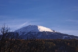
The Tux Alps or Tux Prealps (Tuxer Voralpen) are a sub-group of the Austrian Central Alps, which in turn form part of the Eastern Alps
within Central Europe. They are located entirely within the Austrian federal state of Tyrol. The Tux Alps are one of three mountain ranges that form an Alpine backdrop to the city of Innsbruck
. Their highest peak is the Lizumer Reckner
, , which rises between the glen of Wattentaler Lizum
and the valley of the Navisbach. Their name is derived from the village of Tux which is tucked away in a side valley of the Zillertal
.
The Alpine Club classification of the Eastern Alps (AVE) calls this range the Tux Alps. The name Tux Prealps was declared in the 1984 edition of the AVE as outdated and not longer applicable. The reality is that the mountain range can hardly be described as "prealps" in view of their sheer extent and height. The description only makes any sense when the range is seen in the context of the Zillertal Alps
to the south, which are considerably higher than the Tux Alps and permanently covered in glaciers.
forms the boundary of this range from Innsbruck downstream to the Inn's confluence with the
Ziller. The Ziller valley (Zillertal) borders the range in the east from the mouth of the Ziller on the Inn upstream as far as Mayrhofen
. In the south the Tuxertal
valley outlines the range from Mayrhofen to Hintertux. From there the boundary continues up to the saddle of the Tuxer Joch
and through the Schmirntal valley to Sankt Jodok. To the west the Tux Alps are bounded by the Wipptal
valley from Sankt Jodok downstream to Innsbruck.
The Tuxer Joch
saddle links the Tux Alps to the Zillertal Alps.
The Tux Alps are a popular ski touring
and hiking area. Its ski resorts are Glungezer, Lizum im Wattental, Hochfügen-Hochzillertal, Penken and Kellerjoch, Patscherkofel. The Patscherkofel
mountain was a venue for the 1964
and 1976 Winter Olympics
held in nearby Innsbruck
.
rocks, that are classified as part of the Innsbruck quartz-phyllite complex (quartzitic phyllite
slate). Next to this zone of Paleozoic
rocks to the south there is a localised zone of various Mesozoic
rocks, the so-called Tarntal Mesozoic. This complex zone belongs, like the quartz-phyllite zone, to the tectonic unit of the Lower Eastern Alps. Amongst the rocks of Tarntal Mesozoic may be found dolomite
and limestone
s that are the basis of rock faces (Kalkwand and Torwand) in the area of the Wattentaler Lizum. On the other hand there are also elements of the former ocean bed, in the shape of serpentinite
that make up the Lizumer Reckner. The southern perimeter of the Tux Alps belongs to the tectonically deeper-lying Penninic Hohe Tauern window
. Here in the Tux Alps these are mainly rocks of the Penninic Glockner Nappe (calc-schist envelope of the Tauern). The northeasternmost corner of the Tux Alps, from the area of Schwaz
to Fügen im Zillertal, belongs to the Upper Eastern Alpine greywacke zone
, which consists of Paleozoic rocks. Silver
and copper
were once extensively mined in this zone in the area around Schwaz.
. Nevertheless the route, which was first proposed in 1977, has achieved a greater profile than many of the other trails officially established and maintained by states or rambling clubs.
The 9th day leg of the dream trail runs from Hall in Tirol up to the Glungezer Hut; the next stage over the seven tuxer summits and the Naviser Jöchl to the Lizumer Hut which is operated by the Austrian Alpine Club section at Hall.
The 10th and 11th days run from the Lizumer Hut to the Tuxer Joch Haus, then over the Pluderling Saddle and the Gschützspitze Saddle.
Other long-distance trails in the Tux Alps are the Eagle Way (Adlerweg), the Via Alpina
(red), Olympic Way (Olympiaweg), Glungezer & Geier Way No. 335 (Glungezer&Geier-Weg 335), and Central Alpine Way No. 02a.
Eastern Alps
Eastern Alps is the name given to the eastern half of the Alps, usually defined as the area east of the Splügen Pass in eastern Switzerland. North of the Splügen Pass, the Posterior Rhine forms the border, and south of the pass, the Liro river and Lake Como form the boundary line.-Geography:The...
within Central Europe. They are located entirely within the Austrian federal state of Tyrol. The Tux Alps are one of three mountain ranges that form an Alpine backdrop to the city of Innsbruck
Innsbruck
- Main sights :- Buildings :*Golden Roof*Kaiserliche Hofburg *Hofkirche with the cenotaph of Maximilian I, Holy Roman Emperor*Altes Landhaus...
. Their highest peak is the Lizumer Reckner
Lizumer Reckner
The Lizumer Reckner is, at , the highest mountain in the Tux Alps in the Austrian state of Tyrol.- Location and area :The Lizumer Reckner lies in the centre of the Tux Alps, about 20 kilometres southeast of Innsbruck within the Lizum Walchen Training Area...
, , which rises between the glen of Wattentaler Lizum
Wattentaler Lizum
The Wattentaler Lizum is the name of the head of the Wattental valley which branches off the lower Inn valley near Wattens. Lizum means "alpine pasture at the head of the valley" in Tyrolese...
and the valley of the Navisbach. Their name is derived from the village of Tux which is tucked away in a side valley of the Zillertal
Zillertal
The Zillertal is the biggest valley branching off the Inn valley in Tyrol, Austria drained by the river Ziller. It is surrounded by the strongly glaciated Zillertal Alps to the south and east, the lower grass peaks of the Kitzbühel Alps to the east and Tux Alps to the west...
.
The Alpine Club classification of the Eastern Alps (AVE) calls this range the Tux Alps. The name Tux Prealps was declared in the 1984 edition of the AVE as outdated and not longer applicable. The reality is that the mountain range can hardly be described as "prealps" in view of their sheer extent and height. The description only makes any sense when the range is seen in the context of the Zillertal Alps
Zillertal Alps
The Zillertal Alps are a mountain range of the Central Eastern Alps on the border of Austria and Italy. The range is named after the Zillertal on its north....
to the south, which are considerably higher than the Tux Alps and permanently covered in glaciers.
Neighbouring ranges
The Tux Alps are surrounded by the following other ranges in the Alps:- KarwendelKarwendelThe Karwendel is the largest range of the Northern Limestone Alps. Four chains stretch from west to east; in addition, there are a number of fringe ranges and an extensive promontory in the north....
(to the north) - Brandenberg AlpsBrandenberg AlpsThe Brandenberg Alps are a sub-group of the Northern Limestone Alps, that run in front of the Eastern Alps for their whole length. They lie entirely in Austria between Achensee in Tyrol, the Inn Valley and the Bavarian Prealps....
(to the northeast) - Kitzbühel Alps (to the east)
- Zillertal AlpsZillertal AlpsThe Zillertal Alps are a mountain range of the Central Eastern Alps on the border of Austria and Italy. The range is named after the Zillertal on its north....
(to the south) - Stubai AlpsStubai AlpsThe Stubai Alps is a mountain range in the Central Eastern Alps of Europe. It is named after the Stubaital valley to its east. It is located southwest of Innsbruck, Austria, and several summits of the range form part of Austria's border with Italy...
(to the west)
Boundary
To the north the lower Inn valleyLower Inn Valley
The Lower Inn valley is that part of the Inn valley through which the River Inn flows from a point a few kilometres west of Innsbruck near its confluence with the Melach downstream to a few kilometres before Rosenheim...
forms the boundary of this range from Innsbruck downstream to the Inn's confluence with the
Ziller. The Ziller valley (Zillertal) borders the range in the east from the mouth of the Ziller on the Inn upstream as far as Mayrhofen
Mayrhofen
- Twin towns : Chur, Switzerland Bad Tölz, Germany Bad Homburg, Germany Terracina, Italy Cabourg, France Bad Mondorf, Luxembourg- Transport :Mayrhofen has one railway station, which is located next to the Zillertaler Bundestrasse. The station is a terminus for all Train services operated by the...
. In the south the Tuxertal
Tuxertal
The Tuxertal lies in Tyrol, Austria and is a side valley of the Zillertal, from which it branches at Mayrhofen. It is about 13 km long and accessible on the Tux Road . From Mayrhofen to Hintertux in the municipality of Tux, the village that gives the valley its name, there is a height...
valley outlines the range from Mayrhofen to Hintertux. From there the boundary continues up to the saddle of the Tuxer Joch
Tuxer Joch
The Tuxer Joch is a mountain pass in the Zillertal Alps at a height of that links the lower Zillertal valley with the Brenner route just north of the Brenner Pass. To the northeast just below the summit lies the Tuxer Joch-Haus.- History :...
and through the Schmirntal valley to Sankt Jodok. To the west the Tux Alps are bounded by the Wipptal
Wipptal
The Wipptal is a valley extending along the Sill River southward from Innsbruck, Tyrol, Austria, where the Sill meets the larger Inn river, up to the Brenner Pass at the Austro-Italian border, one of the lowest passes across the Central Eastern Alps...
valley from Sankt Jodok downstream to Innsbruck.
The Tuxer Joch
Tuxer Joch
The Tuxer Joch is a mountain pass in the Zillertal Alps at a height of that links the lower Zillertal valley with the Brenner route just north of the Brenner Pass. To the northeast just below the summit lies the Tuxer Joch-Haus.- History :...
saddle links the Tux Alps to the Zillertal Alps.
The Tux Alps are a popular ski touring
Ski touring
Ski touring is a form of backcountry skiing involving traveling over the winter landscape on skis under human power rather than through the assistance of ski lifts or snow vehicles. It can take place in terrain ranging from perfectly flat to extremely steep...
and hiking area. Its ski resorts are Glungezer, Lizum im Wattental, Hochfügen-Hochzillertal, Penken and Kellerjoch, Patscherkofel. The Patscherkofel
Patscherkofel
Patscherkofel is a mountain and ski area in Tyrol in western Austria, 7 km south of Innsbruck. The peak rises to a summit elevation of 7639 feet above sea level...
mountain was a venue for the 1964
1964 Winter Olympics
The 1964 Winter Olympics, officially known as the IX Olympic Winter Games, were a winter multi-sport event which was celebrated in Innsbruck, Austria, from January 29 to February 9, 1964...
and 1976 Winter Olympics
1976 Winter Olympics
The 1976 Winter Olympics, officially known as the XII Olympic Winter Games, were a winter multi-sport event which was celebrated February 4–15, 1976 in Innsbruck, Austria...
held in nearby Innsbruck
Innsbruck
- Main sights :- Buildings :*Golden Roof*Kaiserliche Hofburg *Hofkirche with the cenotaph of Maximilian I, Holy Roman Emperor*Altes Landhaus...
.
Major peaks
- PatscherkofelPatscherkofelPatscherkofel is a mountain and ski area in Tyrol in western Austria, 7 km south of Innsbruck. The peak rises to a summit elevation of 7639 feet above sea level...
, - GlungezerGlungezerThe Glungezer is a mountain in the Tux Alps in Tyrol southeast of Innsbruck in Austria.- External links :* * * * *...
, - Lizumer RecknerLizumer RecknerThe Lizumer Reckner is, at , the highest mountain in the Tux Alps in the Austrian state of Tyrol.- Location and area :The Lizumer Reckner lies in the centre of the Tux Alps, about 20 kilometres southeast of Innsbruck within the Lizum Walchen Training Area...
, - KellerjochKellerjochThe Kellerjoch is a 2,344 m high, mountain above the Inn valley near Schwaz in Tyrol, Austria.- Weblinks :* official map work* * * , painted by Max Angerer...
, - GilfertGilfertThe Gilfert is a 2,506 metre high peak in the Tux Alps. It is the most northerly extent of the Rastkogel Massif and can therefore be seen from almost anywhere in the Lower Inn Valley.- Location and countryside :...
, - RastkogelRastkogelThe Rastkogel is a 2,762 metre high, pyramidal, mountain on the main crest of the Tux Alps in the Austrian federal state of Tyrol.- Location and area :...
,
Geology
The largest part of the Tux Alps comprises low grade metamorphicMetamorphic facies
The metamorphic facies are groups of mineral compositions in metamorphic rocks, that are typical for a certain field in pressure-temperature space...
rocks, that are classified as part of the Innsbruck quartz-phyllite complex (quartzitic phyllite
Phyllite
Phyllite is a type of foliated metamorphic rock primarily composed of quartz, sericite mica, and chlorite; the rock represents a gradation in the degree of metamorphism between slate and mica schist. Minute crystals of graphite, sericite, or chlorite impart a silky, sometimes golden sheen to the...
slate). Next to this zone of Paleozoic
Paleozoic
The Paleozoic era is the earliest of three geologic eras of the Phanerozoic eon, spanning from roughly...
rocks to the south there is a localised zone of various Mesozoic
Mesozoic
The Mesozoic era is an interval of geological time from about 250 million years ago to about 65 million years ago. It is often referred to as the age of reptiles because reptiles, namely dinosaurs, were the dominant terrestrial and marine vertebrates of the time...
rocks, the so-called Tarntal Mesozoic. This complex zone belongs, like the quartz-phyllite zone, to the tectonic unit of the Lower Eastern Alps. Amongst the rocks of Tarntal Mesozoic may be found dolomite
Dolomite
Dolomite is a carbonate mineral composed of calcium magnesium carbonate CaMg2. The term is also used to describe the sedimentary carbonate rock dolostone....
and limestone
Limestone
Limestone is a sedimentary rock composed largely of the minerals calcite and aragonite, which are different crystal forms of calcium carbonate . Many limestones are composed from skeletal fragments of marine organisms such as coral or foraminifera....
s that are the basis of rock faces (Kalkwand and Torwand) in the area of the Wattentaler Lizum. On the other hand there are also elements of the former ocean bed, in the shape of serpentinite
Serpentinite
Serpentinite is a rock composed of one or more serpentine group minerals. Minerals in this group are formed by serpentinization, a hydration and metamorphic transformation of ultramafic rock from the Earth's mantle...
that make up the Lizumer Reckner. The southern perimeter of the Tux Alps belongs to the tectonically deeper-lying Penninic Hohe Tauern window
Hohe Tauern window
The Hohe Tauern window is a geological structure in the Austrian Central Eastern Alps. It is a window in the Austroalpine nappes where high-grade metamorphic rocks of the underlying Penninic nappes crop out...
. Here in the Tux Alps these are mainly rocks of the Penninic Glockner Nappe (calc-schist envelope of the Tauern). The northeasternmost corner of the Tux Alps, from the area of Schwaz
Schwaz
Schwaz is a city in Tyrol, Austria. It is the administrative center of the Schwaz district . Schwaz is located in the lower Inn valley, and has a population of about 13,000....
to Fügen im Zillertal, belongs to the Upper Eastern Alpine greywacke zone
Greywacke zone
The greywacke zone is a band of Paleozoic metamorphosed sedimentary rocks that forms an east-west band through the Austrian Alps. The greywacke zone crops out between the Mesozoic rocks of the Northern Calcareous Alps and the Austroalpine and Penninic basement rocks of the Central Eastern Alps....
, which consists of Paleozoic rocks. Silver
Silver
Silver is a metallic chemical element with the chemical symbol Ag and atomic number 47. A soft, white, lustrous transition metal, it has the highest electrical conductivity of any element and the highest thermal conductivity of any metal...
and copper
Copper
Copper is a chemical element with the symbol Cu and atomic number 29. It is a ductile metal with very high thermal and electrical conductivity. Pure copper is soft and malleable; an exposed surface has a reddish-orange tarnish...
were once extensively mined in this zone in the area around Schwaz.
Long-distance hiking trails
The long-distance hiking trail known as the "Munich to Venice Dream Path" (Traumpfad München-Venedig) runs through the Tux Alps. This is not an official long-distance trailLong-distance trail
Long-distance trails are the longer recreational trails mainly through rural areas, used for non-motorised recreational travelling ....
. Nevertheless the route, which was first proposed in 1977, has achieved a greater profile than many of the other trails officially established and maintained by states or rambling clubs.
The 9th day leg of the dream trail runs from Hall in Tirol up to the Glungezer Hut; the next stage over the seven tuxer summits and the Naviser Jöchl to the Lizumer Hut which is operated by the Austrian Alpine Club section at Hall.
The 10th and 11th days run from the Lizumer Hut to the Tuxer Joch Haus, then over the Pluderling Saddle and the Gschützspitze Saddle.
Other long-distance trails in the Tux Alps are the Eagle Way (Adlerweg), the Via Alpina
Via Alpina
Via Alpina is a network of five long-distance hiking trails across the alpine regions of Slovenia, Austria, Germany, Liechtenstein, Switzerland, Italy, France, and Monaco....
(red), Olympic Way (Olympiaweg), Glungezer & Geier Way No. 335 (Glungezer&Geier-Weg 335), and Central Alpine Way No. 02a.
Huts
The following Alpine Club huts are located in the Tux Alps:- Glungezer Hut
- Kellerjoch Hut
- Lizumer Hut
- Meißner Haus
- Navis Hut
- Patscherkofelhaus
- Rastkogel Hut
- Vinzenz Tolling Hut
- Voldertal Hut
- Weertal Hut
- Weiden Hut