
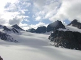
Stubai Alps
Encyclopedia
The Stubai Alps is a mountain range
in the Central Eastern Alps
of Europe
. It is named after the Stubaital
valley to its east. It is located southwest of Innsbruck
, Austria
, and several summits of the range form part of Austria's border with Italy
. The range is bounded by the Inn River
valley to the north; the Sill River
valley (Wipptal
) and the Brenner Pass
to the east (separating it from the Zillertal Alps
); the Ötztal
and Timmelsjoch
to the west (separating it from the Ötztal Alps
), and to the south by tributaries of the Passer River and Eisack
.
es of the Stubai Alps are:
Mountain range
A mountain range is a single, large mass consisting of a succession of mountains or narrowly spaced mountain ridges, with or without peaks, closely related in position, direction, formation, and age; a component part of a mountain system or of a mountain chain...
in the Central Eastern Alps
Central Eastern Alps
The Central Eastern Alps comprise the main chain of the Eastern Alps with its highest peaks, located between the Northern Limestone Alps and the Southern Limestone Alps, from which they differ in geological composition....
of Europe
Europe
Europe is, by convention, one of the world's seven continents. Comprising the westernmost peninsula of Eurasia, Europe is generally 'divided' from Asia to its east by the watershed divides of the Ural and Caucasus Mountains, the Ural River, the Caspian and Black Seas, and the waterways connecting...
. It is named after the Stubaital
Stubaital
The Stubaital is an alpine valley in the Austrian state of Tyrol. It is the central valley of the Stubai Alps. The Ruetz river flows through the valley....
valley to its east. It is located southwest of Innsbruck
Innsbruck
- Main sights :- Buildings :*Golden Roof*Kaiserliche Hofburg *Hofkirche with the cenotaph of Maximilian I, Holy Roman Emperor*Altes Landhaus...
, Austria
Austria
Austria , officially the Republic of Austria , is a landlocked country of roughly 8.4 million people in Central Europe. It is bordered by the Czech Republic and Germany to the north, Slovakia and Hungary to the east, Slovenia and Italy to the south, and Switzerland and Liechtenstein to the...
, and several summits of the range form part of Austria's border with Italy
Italy
Italy , officially the Italian Republic languages]] under the European Charter for Regional or Minority Languages. In each of these, Italy's official name is as follows:;;;;;;;;), is a unitary parliamentary republic in South-Central Europe. To the north it borders France, Switzerland, Austria and...
. The range is bounded by the Inn River
Inn River
The Inn is a river in Switzerland, Austria and Germany. It is a right tributary of the Danube and is approximately 500km long. The highest point of its drainage basin is the summit of Piz Bernina, at 4,049 metres.- Geography :...
valley to the north; the Sill River
Sill River
The Sill is a 35 km long river in Tyrol, Austria. It is one of the larger tributaries of the Inn River in the Austrian Tyrol. It flows through the Wipptal valley north to Innsbruck. Its source lies east of the Brenner Pass. At the "Sillzwickel" - the name of the point where it meets the Inn at...
valley (Wipptal
Wipptal
The Wipptal is a valley extending along the Sill River southward from Innsbruck, Tyrol, Austria, where the Sill meets the larger Inn river, up to the Brenner Pass at the Austro-Italian border, one of the lowest passes across the Central Eastern Alps...
) and the Brenner Pass
Brenner Pass
- Roadways :The motorway E45 leading from Innsbruck via Bolzano to Verona and Modena uses this pass, and is one of the most important north-south connections in Europe...
to the east (separating it from the Zillertal Alps
Zillertal Alps
The Zillertal Alps are a mountain range of the Central Eastern Alps on the border of Austria and Italy. The range is named after the Zillertal on its north....
); the Ötztal
Ötztal
The Ötztal is a 65-kilometer long alpine valley in the Austrian state of Tyrol. The Ötztaler Ache river flows through the valley in a northern direction. The Ötztal separates the Stubai Alps in the east from the Ötztal Alps in the west. The northern end of the valley is at the confluence of the...
and Timmelsjoch
Timmelsjoch
Timmelsjoch , is a high mountain pass that creates a link through the Ötztal Alps along the border between Austria and Italy....
to the west (separating it from the Ötztal Alps
Ötztal Alps
The Ötztal Alps are a mountain range in the central Alps of Europe, part of the Central Eastern Alps. They are arrayed at the head of the Ötztal, a side valley of the Inn River southwest of Innsbruck, Austria; the line of summits forms part of Austria's border with Italy.The western border is the...
), and to the south by tributaries of the Passer River and Eisack
Eisack
The Eisack is a river in Northern Italy, the second largest river in South Tyrol. Its source is near the Brenner Pass, at an altitude of about 1990 m above sea level. The river draws water from an area of about 4,200 km². After about 96 km, it joins the Adige river south of Bolzano. At first the...
.
Peaks
The main mountain peaks of the Stubai Alps are:| Peak | Elevation (m/ft) | |
|---|---|---|
| Zuckerhütl Zuckerhütl The Zuckerhütl is a mountain in Tyrol, Austria. At 3,505 metres , it is the highest peak of the Stubai Alps and at the southern end of the Stubaital.... |
3,507 | 11,506 |
| Schrankogel | 3,496 | 11,469 |
| Ruderhofspitze | 3,474 | 11,397 |
| Sonklarspitze Sonklarspitze The Sonklarspitze, also Sonklarspitz, is a mountain in the Stubai Alps on the border between Tyrol, Austria, and South Tyrol, Italy.- References :* DAV Sektion Siegerland: "Söldens Stille Seite", 1st ed... |
3,467 | 11,374 |
| Wilder Freiger Wilder Freiger The Wilder Freiger is a mountain in the Stubai Alps on the border between Tyrol, Austria, and South Tyrol, Italy.... |
3,426 | 11,241 |
| Wilde Leck | 3,361 | 11,027 |
| Lisenser Fernerkogel Lisenser Fernerkogel The Lisenser Fernerkogel is a mountain in the Stubai Alps of Austria.- Routes :From the Franz Senn Hütte hut it is approximately 3½ hours mostly over glaciers and snow, with a small easy rock scramble at the end.... |
3,298 | 10,820 |
| Habicht Habicht Habicht is a mountain in the Stubai Alps of Austria. For a long time, the locals believed it to be the highest mountain in Tyrol, due to its prominence above the surrounding mountains. Despite what they thought, the highest peak in the Stubai Alps is Zuckerhütl which is 230 metres higher than... |
3,277 | 10,751 |
| Pflerscher Tribulaun | 3,102 | 10,178 |
Passes
The main mountain passMountain pass
A mountain pass is a route through a mountain range or over a ridge. If following the lowest possible route, a pass is locally the highest point on that route...
es of the Stubai Alps are:
| Mountain pass | location | type | elevation (m/ft) | |
|---|---|---|---|---|
| Sonklarscharte | Sölden Sölden Sölden is a municipality in the Ötztal valley of Tyrol, Austria.-Geography:At c. 467 km² , it is the largest municipality in the country. The population of 3,449 is outnumbered by tourists, of which 15,000 can be accommodated... to Sterzing Sterzing Sterzing is a comune in South Tyrol in the region of Trentino-Alto Adige/Südtirol, Italy. It is the main village of the southern Wipptal, and the Eisack River flows through the medieval town.-Origin:... | snow | 3327 | 10,916 |
| Bildstockljoch | Sölden to Ranalt | snow | 3138 | 10,296 |
| Timmelsjoch Timmelsjoch Timmelsjoch , is a high mountain pass that creates a link through the Ötztal Alps along the border between Austria and Italy.... (Passo del Rombo) | Sölden to Meran | road | 2509 | 8232 |
| Jaufen Pass/Passo di Monte Giovo | Sterzing to Meran | road | 2094 | 6870 |
| Brenner Pass Brenner Pass - Roadways :The motorway E45 leading from Innsbruck via Bolzano to Verona and Modena uses this pass, and is one of the most important north-south connections in Europe... | Innsbruck Innsbruck - Main sights :- Buildings :*Golden Roof*Kaiserliche Hofburg *Hofkirche with the cenotaph of Maximilian I, Holy Roman Emperor*Altes Landhaus... to Verona Verona Verona ; German Bern, Dietrichsbern or Welschbern) is a city in the Veneto, northern Italy, with approx. 265,000 inhabitants and one of the seven chef-lieus of the region. It is the second largest city municipality in the region and the third of North-Eastern Italy. The metropolitan area of Verona... | highway, railway | 1370 | 4495 |