
Turrialba Volcano
Encyclopedia
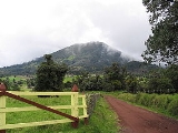
Turrialba Volcano was named after the region of Costa Rica in which the volcano is situated in Turrialba County, Cartago of Costa Rica. There is no clear consensus on the origin of the name Turrialba, but historians disagree with attempts to attribute the name to the patronym Torrealba (from Aragon in Spain
) or from the Latin Turris alba (white tower). The general consensus is that Turrialba derives from a local Indian language (Huetar) but there is no agreement on its actual roots.
The stratovolcano
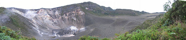
is 3340 m (10,958 ft) high and is about 45 minutes from the Atlantic slope town of Turrialba. The summit has three craters, one of which has fumarole
s and sulfur
pits. Visitors used to be able to hike down into the main crater, but increased gaseous activity has caused the time at the summit to be limited to no more than fifteen minutes. The hike to the top from where the vans usually are forced to stop takes about one to three hours depending on the ability of the hikers. Below the summit is a mountain range and cloud forest, with fern
s, bromeliads, lichen
s and moss
es. During the 19th century, it explosively erupted several times (1847?, 1853, 1855, 1861?, 1864–1865, 1866), producing pyroclastic flow
s. The last major eruption was in 1866, but in January 2001, the volcano reported increased activity, displaying strong fumaroles at the central craters. The volcanic activities have increased since 2005. In January 2010, the volcano emitted ash, and two villages, La Central and El Retiro, were evacuated.
Turrialba is adjacent to Irazú
and both are among Costa Rica's largest volcanoes. It had at least five large explosive eruptions in last 3500 years.
A viewing platform (Mirador) and path and steps were built overlooking the crater by volunteers from the charity Raleigh International in 2007. On clear days both the Pacific Ocean and Caribbean Sea can be seen.
Spain
Spain , officially the Kingdom of Spain languages]] under the European Charter for Regional or Minority Languages. In each of these, Spain's official name is as follows:;;;;;;), is a country and member state of the European Union located in southwestern Europe on the Iberian Peninsula...
) or from the Latin Turris alba (white tower). The general consensus is that Turrialba derives from a local Indian language (Huetar) but there is no agreement on its actual roots.
The stratovolcano
Stratovolcano
A stratovolcano, also known as a composite volcano, is a tall, conical volcano built up by many layers of hardened lava, tephra, pumice, and volcanic ash. Unlike shield volcanoes, stratovolcanoes are characterized by a steep profile and periodic, explosive eruptions...
is 3340 m (10,958 ft) high and is about 45 minutes from the Atlantic slope town of Turrialba. The summit has three craters, one of which has fumarole
Fumarole
A fumarole is an opening in a planet's crust, often in the neighborhood of volcanoes, which emits steam and gases such as carbon dioxide, sulfur dioxide, hydrochloric acid, and hydrogen sulfide. The steam is created when superheated water turns to steam as its pressure drops when it emerges from...
s and sulfur
Sulfur
Sulfur or sulphur is the chemical element with atomic number 16. In the periodic table it is represented by the symbol S. It is an abundant, multivalent non-metal. Under normal conditions, sulfur atoms form cyclic octatomic molecules with chemical formula S8. Elemental sulfur is a bright yellow...
pits. Visitors used to be able to hike down into the main crater, but increased gaseous activity has caused the time at the summit to be limited to no more than fifteen minutes. The hike to the top from where the vans usually are forced to stop takes about one to three hours depending on the ability of the hikers. Below the summit is a mountain range and cloud forest, with fern
Fern
A fern is any one of a group of about 12,000 species of plants belonging to the botanical group known as Pteridophyta. Unlike mosses, they have xylem and phloem . They have stems, leaves, and roots like other vascular plants...
s, bromeliads, lichen
Lichen
Lichens are composite organisms consisting of a symbiotic organism composed of a fungus with a photosynthetic partner , usually either a green alga or cyanobacterium...
s and moss
Moss
Mosses are small, soft plants that are typically 1–10 cm tall, though some species are much larger. They commonly grow close together in clumps or mats in damp or shady locations. They do not have flowers or seeds, and their simple leaves cover the thin wiry stems...
es. During the 19th century, it explosively erupted several times (1847?, 1853, 1855, 1861?, 1864–1865, 1866), producing pyroclastic flow
Pyroclastic flow
A pyroclastic flow is a fast-moving current of superheated gas and rock , which reaches speeds moving away from a volcano of up to 700 km/h . The flows normally hug the ground and travel downhill, or spread laterally under gravity...
s. The last major eruption was in 1866, but in January 2001, the volcano reported increased activity, displaying strong fumaroles at the central craters. The volcanic activities have increased since 2005. In January 2010, the volcano emitted ash, and two villages, La Central and El Retiro, were evacuated.
Turrialba is adjacent to Irazú
Irazú Volcano
The Irazú Volcano is an active volcano in Costa Rica, situated in the Cordillera Central close to the city of Cartago.The name could come from either the combination of "ara" and "tzu" or a corruption of Iztarú, which was the name of an indigenous village on the flanks of the volcano...
and both are among Costa Rica's largest volcanoes. It had at least five large explosive eruptions in last 3500 years.
A viewing platform (Mirador) and path and steps were built overlooking the crater by volunteers from the charity Raleigh International in 2007. On clear days both the Pacific Ocean and Caribbean Sea can be seen.