
Turners Falls Road Bridge
Encyclopedia
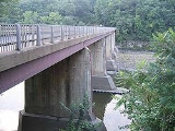
The Turners Falls Road Bridge (officially White Bridge) is a concrete and steel road bridge over the Connecticut River
Connecticut River
The Connecticut River is the largest and longest river in New England, and also an American Heritage River. It flows roughly south, starting from the Fourth Connecticut Lake in New Hampshire. After flowing through the remaining Connecticut Lakes and Lake Francis, it defines the border between the...
in the U.S. state
U.S. state
A U.S. state is any one of the 50 federated states of the United States of America that share sovereignty with the federal government. Because of this shared sovereignty, an American is a citizen both of the federal entity and of his or her state of domicile. Four states use the official title of...
of Massachusetts
Massachusetts
The Commonwealth of Massachusetts is a state in the New England region of the northeastern United States of America. It is bordered by Rhode Island and Connecticut to the south, New York to the west, and Vermont and New Hampshire to the north; at its east lies the Atlantic Ocean. As of the 2010...
. It carries Turners Falls Road and connects the town center of Greenfield
Greenfield, Massachusetts
Greenfield is a city in Franklin County, Massachusetts, United States. The population was 17,456 at the 2010 census. It is the county seat of Franklin County. Greenfield is home to Greenfield Community College, the Pioneer Valley Symphony Orchestra, and the Franklin County Fair...
and the village of Turners Falls
Turners Falls, Massachusetts
Turners Falls is an unincorporated village and census-designated place in the town of Montague in Franklin County, Massachusetts, United States. The population was 4,441 at the 2000 census. It is part of the Springfield, Massachusetts Metropolitan Statistical Area...
(in the town of Montague
Montague, Massachusetts
Montague is a town in Franklin County, Massachusetts, United States. The population was 8,489 at the 2000 census. It is part of the Springfield, Massachusetts metropolitan statistical area....
).
History
The current bridge is the second on this site. Previously, a suspension bridge constructed in 1871 and known as the "Lower Suspension Bridge" was located at the site. The old bridge was constructed with funds from the towns of Greenfield and Montague and cost about $36,000. A road connecting the bridge to Greenfield center was laid out by the following year. The bridge was constructed primarily to allow laborers in Greenfield to easily go to the newly developing village of Turners Falls. The previous bridge was severely damaged in the 1936 flood and the current bridge was constructed soon after.In the 1920s, Route 2
Route 2 (Massachusetts)
Route 2 is a major east–west state highway in Massachusetts, parts of which are sometimes known as the Cambridge and Concord Turnpike. Along with Route 9 and U.S. Route 20 to the south, these highways are the main alternatives to the Massachusetts Turnpike/I-90 toll highway...
(former New England Route 7) originally left Greenfield via Turners Falls Road, crossing the old suspension bridge into the village of Turners Falls. Route 2 left Turners Falls via Millers Falls Road. In 1932, a more modern bridge capable of handling the increased automobile traffic, the French King Bridge
French King Bridge
The French King Bridge is a three-span "cantilever arch" style bridge crossing the Connecticut River on the border of the towns of Erving and Gill, Massachusetts...
, opened further upstream and Route 2 was relocated to its modern alignment along French King Highway. The former alignment through Turners Falls was designated as Route 2A
Route 2A (Massachusetts)
Route 2A exists in several sections of Massachusetts, mainly as parts of former Route 2 that have been moved or upgraded. Route 2A runs from Greenfield in the west to Boston in the east...
. The Route 2A designation remained on Turners Falls Road until the 1960s.
The Massachusetts Highway Department
Massachusetts Highway Department
The Massachusetts Highway Department was the former name of the highway department in the United States Commonwealth of Massachusetts from 1991 until it became the highway division of the Massachusetts Department of Transportation on November 1, 2009...
is currently in the planning stages for a rehabilitation project for this bridge.