
Tufanbeyli
Encyclopedia
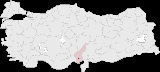
Tufanbeyli is small city and a district in Adana Province
of Turkey
, 196 km north-east of the city of Adana
, on an uneven, sloping plateau high in the Tahtalı range of the Toros
mountains. It has been bounded economically to Kayseri
, 178 km far. Its neighbors are Sarız
from North, Göksun
from east, Saimbeyli
from south, Develi
from south-west and Tomarza
from west.
Tufanbeyli is reached by crossing one of three high mountain passes. It's a struggle to reach but the views are incredible. The river Göksu
, a tributary of the Seyhan
runs across the plateau. The climate is hot dry summers and cold winters. The mountains are forested but these are steadily being consumed by the local people.
. In classical antiquity, the region of Tufanbeyli was in the southwestern corner of Cappadocia
(while the parts of the Adana region south of Tufanbeyli were in Cilicia
). The city of Comana
was situated near Şarköy, some kilometers north of Tufanbeyli.
The area is now settled by descendants of Turks from the Caucasus
and the Avşar
(Afshar
tribe; the former having come to Anatolia
as a result of the Russian influx into the Caucasus in the 18th and 19th centuries. The latter being one of the group of Turkish migrants from Asia that have preserved their clan identity in Anatolia. The Avşar played a key role in the Turkish conquest of the Çukurova
region and remained a local authority right up until the 19th century, especially in mountain strongholds like Tufanbeyli. Its former names were Höketçe before 1923 and Mağara between 1923-1967. It was become a district in 1958 with separating from Saimbeyli.
Adana Province
Adana Province is a province of Turkey located in south-central Anatolia. With a population of 2,085,225, it is the fifth most populous province in Turkey. The administrative seat of the province is the city of Adana, home to 78% of the residents of the province...
of Turkey
Turkey
Turkey , known officially as the Republic of Turkey , is a Eurasian country located in Western Asia and in East Thrace in Southeastern Europe...
, 196 km north-east of the city of Adana
Adana
Adana is a city in southern Turkey and a major agricultural and commercial center. The city is situated on the Seyhan River, 30 kilometres inland from the Mediterranean, in south-central Anatolia...
, on an uneven, sloping plateau high in the Tahtalı range of the Toros
Toros
Toros may refer to:Sports*Austin Toros, NBA Development League minor league basketball team*Western District Toros, a soccer club from Adelaide, South AustraliaGeography*Taurus Mountains , a mountain range in southern Turkey...
mountains. It has been bounded economically to Kayseri
Kayseri
Kayseri is a large and industrialized city in Central Anatolia, Turkey. It is the seat of Kayseri Province. The city of Kayseri, as defined by the boundaries of Kayseri Metropolitan Municipality, is structurally composed of five metropolitan districts, the two core districts of Kocasinan and...
, 178 km far. Its neighbors are Sarız
Sariz
Sarız is a town and district of Kayseri Province in the Central Anatolia region of Turkey. The mayor is Ömer Faruk Eroğlu ....
from North, Göksun
Göksun
Göksun is a town and district of Kahramanmaraş Province in the Mediterranean region of Turkey.- History :The town has an ancient history, first included in Cataonia, then in Cappadocia...
from east, Saimbeyli
Saimbeyli
Saimbeyli is a small city and a district in Adana Province, Turkey in what was known during the Middle Ages as Cilician Armenia. The city of Saimbeyli is in the Toros mountains, 157 km north of the city of Adana, by a difficult road...
from south, Develi
Develi
Develi is a town and district in Kayseri Province in Central Anatolia Region, Turkey.-History:The town's name is reported to derive from Devle Bey, a Seljuk commander of Alp Arslan, , and who was also named Dev Ali , and leader of an Oghuz Turkish clan of the same or of a similar name...
from south-west and Tomarza
Tomarza
Tomarza is a town and district of Kayseri Province in the Central Anatolia region of Turkey. It seems that Tomarza was the center of an Armenian autonomy, along with Zeytun/Süleymanlı and Göksun in the 17th century. The mayor is Fahrettin Işık ....
from west.
Tufanbeyli is reached by crossing one of three high mountain passes. It's a struggle to reach but the views are incredible. The river Göksu
Göksu
The Göksu is a river in Taşeli Peninsula . Both its sources arise in the Taurus Mountains—the northern in the Geyik Mountains and the southern in the Haydar Mountains...
, a tributary of the Seyhan
Seyhan
Seyhan is a district in the Adana Province of Turkey. It is completely within the city of Adana and the municipality of Seyhan is a lower-tier municipality which serves to the entire district....
runs across the plateau. The climate is hot dry summers and cold winters. The mountains are forested but these are steadily being consumed by the local people.
History
During the Bronze Age, the area was part of the kingdom of KizzuwatnaKizzuwatna
Kizzuwatna , is the name of an ancient Anatolian kingdom in the second millennium BC. It was situated in the highlands of southeastern Anatolia, near the Gulf of İskenderun in modern-day Turkey. It encircled the Taurus Mountains and the Ceyhan river. The center of the kingdom was the city of...
. In classical antiquity, the region of Tufanbeyli was in the southwestern corner of Cappadocia
Cappadocia
Cappadocia is a historical region in Central Anatolia, largely in Nevşehir Province.In the time of Herodotus, the Cappadocians were reported as occupying the whole region from Mount Taurus to the vicinity of the Euxine...
(while the parts of the Adana region south of Tufanbeyli were in Cilicia
Cilicia
In antiquity, Cilicia was the south coastal region of Asia Minor, south of the central Anatolian plateau. It existed as a political entity from Hittite times into the Byzantine empire...
). The city of Comana
Comana, Cappadocia
Comana was a city of Cappadocia and later Cataonia . The Hittite toponym Kummanni is considered likely to refer to Comana, but the identification is not considered proven. Its ruins are at the modern Turkish village of Şar, Tufanbeyli district, Adana Province.-History:According to ancient...
was situated near Şarköy, some kilometers north of Tufanbeyli.
The area is now settled by descendants of Turks from the Caucasus
Caucasus
The Caucasus, also Caucas or Caucasia , is a geopolitical region at the border of Europe and Asia, and situated between the Black and the Caspian sea...
and the Avşar
Avsar
Avşar is a village and municipality in the Aghjabadi Rayon of Azerbaijan. It has a population of 5,600.- Notable natives :* Namig Abdullayev — National Hero of Azerbaijan....
(Afshar
Afshar
Afshar is a district of Kabul, Afghanistan. Most of its population are of the Shia-Hazara ethnic group....
tribe; the former having come to Anatolia
Anatolia
Anatolia is a geographic and historical term denoting the westernmost protrusion of Asia, comprising the majority of the Republic of Turkey...
as a result of the Russian influx into the Caucasus in the 18th and 19th centuries. The latter being one of the group of Turkish migrants from Asia that have preserved their clan identity in Anatolia. The Avşar played a key role in the Turkish conquest of the Çukurova
Çukurova
Çukurova , historically known as Cilicia, is a geographic, economic and cultural region in south-central Turkey, covering the provinces of Mersin, Adana, Osmaniye and Hatay...
region and remained a local authority right up until the 19th century, especially in mountain strongholds like Tufanbeyli. Its former names were Höketçe before 1923 and Mağara between 1923-1967. It was become a district in 1958 with separating from Saimbeyli.