
Tropical Cyclone Les
Encyclopedia
Tropical Cyclone Les was a Category 2 storm in the 1997-98 Australian region cyclone season
, which affected the Northern Territory
of Australia
in January 1998.
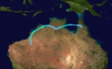
developed over the Gulf of Carpentaria
. Little development occurred as the system traveled initially towards the southwest and later towards the east. Late on January 21, the low moved over the Cape York Peninsula
and began to strengthen. A surge of moisture from a northwest monsoon
and a tightening pressure gradient
due to an area of high pressure
located over the Great Australian Bight
, allowed the system to develop. The first warning published by the Australian Bureau of Meteorology was issued on January 23, after the storm had moved back over the Gulf of Carpentaria.
. Total damages from the storm amounted to at least A$100 million ($64.7 million USD). On January 27, a state of emergency was declared for Katherine as the Katherine River
reached a level of 20.3 m (66.6 ft). Two days later, 392 residents were evacuated from the Daly River region
by helicopter due to the threat of flooding. The following day, Prime minister John Howard
visited the flooded areas in Katherine and requested A$5 million ($3.2 million USD) to repair the Stuart Highway
and assist residents in need of aid.
1997-98 Australian region cyclone season
The 1997–98 Australian region cyclone season was an event in the ongoing cycle of tropical cyclone formation. It ran from 1 November 1997 to 30 April 1998...
, which affected the Northern Territory
Northern Territory
The Northern Territory is a federal territory of Australia, occupying much of the centre of the mainland continent, as well as the central northern regions...
of Australia
Australia
Australia , officially the Commonwealth of Australia, is a country in the Southern Hemisphere comprising the mainland of the Australian continent, the island of Tasmania, and numerous smaller islands in the Indian and Pacific Oceans. It is the world's sixth-largest country by total area...
in January 1998.
Meteorological history
On January 19, 1998, an area of low pressureLow pressure area
A low-pressure area, or "low", is a region where the atmospheric pressure at sea level is below that of surrounding locations. Low-pressure systems form under areas of wind divergence which occur in upper levels of the troposphere. The formation process of a low-pressure area is known as...
developed over the Gulf of Carpentaria
Gulf of Carpentaria
The Gulf of Carpentaria is a large, shallow sea enclosed on three sides by northern Australia and bounded on the north by the Arafura Sea...
. Little development occurred as the system traveled initially towards the southwest and later towards the east. Late on January 21, the low moved over the Cape York Peninsula
Cape York Peninsula
Cape York Peninsula is a large remote peninsula located in Far North Queensland at the tip of the state of Queensland, Australia, the largest unspoilt wilderness in northern Australia and one of the last remaining wilderness areas on Earth...
and began to strengthen. A surge of moisture from a northwest monsoon
Monsoon
Monsoon is traditionally defined as a seasonal reversing wind accompanied by corresponding changes in precipitation, but is now used to describe seasonal changes in atmospheric circulation and precipitation associated with the asymmetric heating of land and sea...
and a tightening pressure gradient
Pressure gradient
In atmospheric sciences , the pressure gradient is a physical quantity that describes in which direction and at what rate the pressure changes the most rapidly around a particular location. The pressure gradient is a dimensional quantity expressed in units of pressure per unit length...
due to an area of high pressure
High pressure area
A high-pressure area is a region where the atmospheric pressure at the surface of the planet is greater than its surrounding environment. Winds within high-pressure areas flow outward due to the higher density air near their center and friction with land...
located over the Great Australian Bight
Great Australian Bight
The Great Australian Bight is a large bight, or open bay, off the central and western portions of the southern coastline of mainland Australia.-Extent:...
, allowed the system to develop. The first warning published by the Australian Bureau of Meteorology was issued on January 23, after the storm had moved back over the Gulf of Carpentaria.
Impact and aftermath
The intense rainfall also occurred during "king high tides" in the Timor Sea that pushed water from the lower reaches upstream, as a result, floodwater drainage was impeded. Many residents were evacuated to cyclone shelters. Several people were stranded on rooftops, and 3 people drowned during the storm. The cyclone dumped over 380mm of rainfall in the area within a 48 hour period. The flooding forced at least 2,000 people out of their homes as 2 m (6.5 ft) of muddy water inundated Katherine, Northern TerritoryKatherine, Northern Territory
Katherine is a town situated southeast of Darwin in the "Top End" of Australia in the Northern Territory. It is the fourth largest settlement in the Territory after the capital Darwin, Palmerston and Alice Springs...
. Total damages from the storm amounted to at least A$100 million ($64.7 million USD). On January 27, a state of emergency was declared for Katherine as the Katherine River
Katherine River
Katherine River is located in the Northern Territory, Australia. Its headwaters are in Nitmiluk National Park, it flows through the town of Katherine, and is a major tributary of the Daly River....
reached a level of 20.3 m (66.6 ft). Two days later, 392 residents were evacuated from the Daly River region
Daly River, Northern Territory
Daly River is the name of a river and a town in the Northern Territory of Australia. At the 2006 census, Daly River had a population of 468.- History :...
by helicopter due to the threat of flooding. The following day, Prime minister John Howard
John Howard
John Winston Howard AC, SSI, was the 25th Prime Minister of Australia, from 11 March 1996 to 3 December 2007. He was the second-longest serving Australian Prime Minister after Sir Robert Menzies....
visited the flooded areas in Katherine and requested A$5 million ($3.2 million USD) to repair the Stuart Highway
Stuart Highway
The Stuart Highway is one of Australia's major highways. It is a segment of Australia's Highway 1 extending from Darwin, Northern Territory, in the north, via Tennant Creek and Alice Springs, to Port Augusta, South Australia, in the south—a distance of...
and assist residents in need of aid.
See also
- 1997-98 Australian region cyclone season1997-98 Australian region cyclone seasonThe 1997–98 Australian region cyclone season was an event in the ongoing cycle of tropical cyclone formation. It ran from 1 November 1997 to 30 April 1998...