

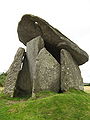
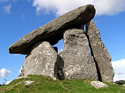
Trethevy Quoit
Encyclopedia
Tomb
A tomb is a repository for the remains of the dead. It is generally any structurally enclosed interment space or burial chamber, of varying sizes...
located near St Cleer
St Cleer
St Cleer is a civil parish and village in Cornwall, United Kingdom. The village is situated on the southeast flank of Bodmin Moor approximately two miles north of Liskeard....
, Cornwall
Cornwall
Cornwall is a unitary authority and ceremonial county of England, within the United Kingdom. It is bordered to the north and west by the Celtic Sea, to the south by the English Channel, and to the east by the county of Devon, over the River Tamar. Cornwall has a population of , and covers an area of...
, United Kingdom
United Kingdom
The United Kingdom of Great Britain and Northern IrelandIn the United Kingdom and Dependencies, other languages have been officially recognised as legitimate autochthonous languages under the European Charter for Regional or Minority Languages...
. It is known locally as "the giant's house". Standing 9 feet (2.7 m) high, it consists of five standing stones capped by a large slab.
Location
Trethevy Quoit is situated in the CaradonCaradon
Caradon was a local government district in Cornwall, United Kingdom. It contained five towns: Callington, Liskeard, Looe, Saltash and Torpoint, and over 80 villages and hamlets within 41 civil parishes...
District north of Liskeard
Liskeard
Liskeard is an ancient stannary and market town and civil parish in south east Cornwall, England, United Kingdom.Liskeard is situated approximately 20 miles west of Plymouth, west of the River Tamar and the border with Devon, and 12 miles east of Bodmin...
in the village of Tremar Coombe
Tremar Coombe
Tremar Coombe is a small hamlet situated in the Caradon District north of Liskeard in Cornwall. "Tremar" means "Mark's farm" in Cornish. It is considered an "industrial settlement" in that it was largely constructed during the mid-nineteenth century to accommodate workers at nearby mines and...
. Nearby are The Hurlers
The Hurlers (stone circles)
The Hurlers are a group of three stone circles in Cornwall, England, UK. The site is half-a-mile west of the village of Minions on the eastern flank of Bodmin Moor, and approximately four miles north of Liskeard at .-Location:The Hurlers are in the Caradon district north of Liskeard in the...
, three stone circles dating from the late Bronze Age
Bronze Age
The Bronze Age is a period characterized by the use of copper and its alloy bronze as the chief hard materials in the manufacture of some implements and weapons. Chronologically, it stands between the Stone Age and Iron Age...
. The site is managed by the Cornwall Heritage Trust on behalf of English Heritage
English Heritage
English Heritage . is an executive non-departmental public body of the British Government sponsored by the Department for Culture, Media and Sport...
.
Construction
Like other portal tombs of this type, Trethevy Quoit was originally covered by a mound. The remnants of this suggest a diameter of 6.5 meters. The remaining seven stones and the 3.7 m long and 10.5-ton cover slab were inside the mound. At the upper end of the cover slab is a natural hole, which may have been used for astronomical observation. The group of horizontal stones is composed of a fallen back wall, two side wall stones, which overlap, a front stone and a somewhat remote flanking stone. The special feature of Cornish portal graves is that by such stones sometimes a smaller partially closed area is created before the front end. Some stones have hole-like perforations as decoration. The front stone is often called an entrance stone, although in most portal graves this can not be moved. The Trevethy Quoit is a rare exception here, because a small rectangular stone moving at the bottom right of the front allows access to the grave chamber, which is now opened only very rarely. The back of the chamber has collapsed inwards and now forms a pile inside the chamber. Erected this stone would be about the height of the front stone, so that the cover slab would not have once been held-up by the side stones, but rested almost horizontal solely on the front stone and rear walls. However, there would have been between the support stones and the side walls a considerable gap, by which soil could have penetrated into the grave chamber. It is therefore likely that the collapse of the rear wall and the falling-down of the cover slab damaged the side stones.Studies

William Copeland Borlase
William Copeland Borlase FSA was an antiquarian and Liberal politician who sat in the House of Commons from 1880 until 1887 when he was ruined by bankruptcy and scandal....
studied the site and made drawings. From it came the first conjectures on the overturned back wall and the earlier appearance of quoit. Hencken in 1932 wrote the first modern representation, in which he explained the special nature of the antechamber, and pointed out parallels to structures in Brittany
Brittany
Brittany is a cultural and administrative region in the north-west of France. Previously a kingdom and then a duchy, Brittany was united to the Kingdom of France in 1532 as a province. Brittany has also been referred to as Less, Lesser or Little Britain...
. Recent excavations showed that this type of megalith was erected in the Neolithic period between 3700-3500 BC and were used over a long period of time as community graves.