

Transport in São Paulo
Encyclopedia
São Paulo
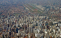
São Paulo is the largest city in Brazil, the largest city in the southern hemisphere and South America, and the world's seventh largest city by population. The metropolis is anchor to the São Paulo metropolitan area, ranked as the second-most populous metropolitan area in the Americas and among...
consists of a complex system with many subsystems. On a daily basis, people from the various municipalities and the metropolitan area
Metropolitan area
The term metropolitan area refers to a region consisting of a densely populated urban core and its less-populated surrounding territories, sharing industry, infrastructure, and housing. A metropolitan area usually encompasses multiple jurisdictions and municipalities: neighborhoods, townships,...
of São Paulo
Greater São Paulo
The Greater São Paulo is a nonspecific term for one of the multiple definitions the large metropolitan area located in the São Paulo state in Brazil.-Definitions:-Metropolitan Area:...
travel into the city, so there are transportation needs on a regional and municipal scale. The city is known for the convergence of several state and federal highways; as a result, large numbers of travelers, and large quantities of cargo, pass through the city en route to various destinations. The transport in São Paulo is commonly referred to as chaotic, although most experts consider that term superficial. Proposed improvements to the system are often important issues in political elections
Elections in Brazil
Brazil elects on the national level a head of state – the president – and a legislature. The president is elected to a four-year term by the people. The National Congress has two chambers. The Chamber of Deputies has 513 members, elected to a four-year term by proportional...
, including the current Brazilian presidential election.
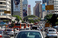
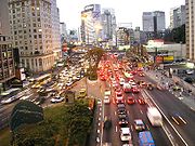
Thanks to a fleet of 6 million cars, one of the largest in the world, Sao Paulo suffers from chronic congestion
Traffic congestion
Traffic congestion is a condition on road networks that occurs as use increases, and is characterized by slower speeds, longer trip times, and increased vehicular queueing. The most common example is the physical use of roads by vehicles. When traffic demand is great enough that the interaction...
on its main routes. Despite a lack of infrastructure, public transportation plays a key role in day-to-day life of the metropolis
Metropolis
A metropolis is a very large city or urban area which is a significant economic, political and cultural center for a country or region, and an important hub for regional or international connections and communications...
. São Paulo
São Paulo
São Paulo is the largest city in Brazil, the largest city in the southern hemisphere and South America, and the world's seventh largest city by population. The metropolis is anchor to the São Paulo metropolitan area, ranked as the second-most populous metropolitan area in the Americas and among...
has an immense bus system, with a fleet of over 16,000 units, under the responsibility of SPTrans. There are also several train systems: CPTM, the São Paulo Metro
São Paulo Metro
The São Paulo Metro is the principal rapid-transit system in the city of São Paulo and the largest in Brazil. It is also the second largest system in South America and the third largest in Latin America, behind Mexico City and Santiago....
, and the EMTU-SP, plus various connecting lines. A contactless smartcard solution Bilhete Único
Bilhete Único
Bilhete Único is the name of the São Paulo transportation contactless smart card system for fare control.Using Philips Mifare technology, the solution is managed by , the city bus transportation authority, which is controlled by municipal government...
(Unified ticket) is used for fare collection and control for buses, subway
São Paulo Metro
The São Paulo Metro is the principal rapid-transit system in the city of São Paulo and the largest in Brazil. It is also the second largest system in South America and the third largest in Latin America, behind Mexico City and Santiago....
and train; using the card allows riders discounted prices for multiple rides and makes for easier transitions between transit systems.
Buses


Trolleybus
A trolleybus is an electric bus that draws its electricity from overhead wires using spring-loaded trolley poles. Two wires and poles are required to complete the electrical circuit...
. Except for a small network overseen by EMTU, all bus lines are operated by concessionaires under the supervision of SPTrans (São Paulo Transporte SA), a municipal company responsible for planning and management of public transport. The SPTrans fleet is coloured uniformly; some vehicles are painted in white, while others are painted with colors that correspond to the particular non-central region served (e.g., light green for the buses that serve the northwest region, dark blue for the northern area). Until a few years ago, informal transport vans (dab vans) had a large presence in the city, but the vast majority of such vans are now already fully registered with the city council, legalized and operating under the same color scheme used for the main system.
To assist in the smooth flow of traffic, several busway
Busway
Busway may refer to several things:Transport technology* Bus rapid transit, bus systems including some elements of trams or metro systems* Guided busway, concrete tracks exclusively for modified busesTransport systems...
s were built throughout the city. Besides these corridors, the city has a system called Expresso Tiradentes
Expresso Tiradentes
Expresso Tiradentes is the bus rapid transit system in São Paulo, Brazil. It is a mid-capacity transportation system that began construction in mid- 1997 , under the name of Fura-Fila...
, with a considerable expansion already under construction.
The payment of fares on buses can be made in cash or by a stored-value card
Stored-value card
A stored-value card refers to monetary value on a card not in an externally recorded account and differs from prepaid cards where money is on deposit with the issuer similar to a debit card...
called Bilhete Único
Bilhete Único
Bilhete Único is the name of the São Paulo transportation contactless smart card system for fare control.Using Philips Mifare technology, the solution is managed by , the city bus transportation authority, which is controlled by municipal government...
.
Underground and light rail system

São Paulo Metro
The São Paulo Metro is the principal rapid-transit system in the city of São Paulo and the largest in Brazil. It is also the second largest system in South America and the third largest in Latin America, behind Mexico City and Santiago....
, locally known as the Metrô
Metró
Metró was a very famous Hungarian rock band in the 1960s and early 1970s. When the Hungarian government cracked down on rock music that they considered subversive, Metró left the music industry. Band leader Zorán Sztevanovity has pursued an active solo career after his tenure with the band....
), with 4 lines in operation and 58 stations, complemented by another 260.7 km of Companhia Paulista de Trens Metropolitanos
Companhia Paulista de Trens Metropolitanos
Companhia Paulista de Trens Metropolitanos is a commuter rail company owned by the São Paulo State Secretariat for Metropolitan Transports. It was created in 1992 from several railroads that already existed in Greater São Paulo, Brazil....
(CPTM, or "Paulista Company of Metropolitan Trains") railways. Both CPTM and the underground railway lines carry some 5.2 million people on an average weekday, and a few new underground lines to be constructed are expected to add another million people to the system within the next five years. The projects expected to expand São Paulo's urban railway system from the current 322.2 km to more than 500 km on the next 10 years.
São Paulo has three rapid transport systems:
- The underground rail system (called "metrô", short for "metropolitano"), with three completed and two partially completed lines.
- The suburban rail system, Companhia Paulista de Trens MetropolitanosCompanhia Paulista de Trens MetropolitanosCompanhia Paulista de Trens Metropolitanos is a commuter rail company owned by the São Paulo State Secretariat for Metropolitan Transports. It was created in 1992 from several railroads that already existed in Greater São Paulo, Brazil....
(CPTM), has six lines that serve many regions not reached by the underground system, and even some other cities in the metropolitan region. The CPTM network is longer than the underground rail system. - The fast-lane bus system: there are many such bus lines in the city, called "Passa Rápido", which are street-level, placed on large avenues, and connected with the underground or suburban train stations.
São Paulo has no tram lines, although trams used to be common in the first half of the 20th century.
São Paulo's underground train system is modern, safe, clean and efficient, considered one of the best subway systems in the world, as certified by the NBR ISO 9001. It has five lines and links to the metropolitan train network, the CPTM.
The underground rail lines are:
- São Paulo MetroSão Paulo MetroThe São Paulo Metro is the principal rapid-transit system in the city of São Paulo and the largest in Brazil. It is also the second largest system in South America and the third largest in Latin America, behind Mexico City and Santiago....
- Line 1 - Blue: The first Metrô line built connects the North and the South Side of São Paulo. Connections are available for the Green, Red and Yellow lines and also for CPTM trains. Tietê and Jabaquara bus terminals are also reachable through the use of this line.
- Line 2 - Green: The Green line transverses the Avenida Paulista ridge, connecting Ipiranga to Vila Madalena, and also integrating the Blue and Yellow lines.
- Line 3 - Red: One of São Paulo's busiest lines, it connects the East Side to the West Side. Connections to the Blue and Yellow lines are possible, as are with CPTM trains. The Barra Funda bus terminal is located on this line.
- Line 4 - Yellow The Yellow line connects the central Luz station to the South side in a route constructed immediately below the Consolação and Rebouças avenues. Connections are available to the Blue, Green and Red lines and to CPTM trains.
- Line 5 - Lilac: Built for users who need to reach specific places in São Paulo's South Side. Only a short distance of the line is already available (six complete stations), connecting to CPTM trains at Santo Amaro station.
- Line 6 - Orange (planned): Announced in 2008 and scheduled to be open in 2012, the Orange Line will connect the borough of Freguesia do Ó, in the northwestern side of the city to downtown São Paulo. It will be connected to the subway lines 1 and 4, as well as the line 7 of CPTM.
- CPTM:
The following lines are composed by surface trains and managed by CPTM, named after precious stones:
- Line 7 - Ruby: Formerly the northern part of the ancient São Paulo RailwaySão Paulo RailwaySão Paulo Railway was a privately owned British railway company in Brazil, which operated the gauge railway from the seaport at Santos via São Paulo to Jundiaí...
, it connects the Luz station downtown to the city of Francisco MoratoFrancisco MoratoFrancisco Morato is a suburban city in the state of São Paulo in Brazil. The population in 2006 is 170,585, its density is 3470 inh./km² and the area is 49 km².The suburban city is served by a CPTM line....
, crossing all of the northwestern side of the city. An operational extension connects Francisco Morato to the city of JundiaíJundiaíJundiaí is a city and municipality in the state of São Paulo, Brazil. The population in 2009 was 349,929, and the area is 433.958 km². The elevation is 761 m. Distance is 60 km north of the city of São Paulo.- History and Geography :...
. This is the longest line of the railway system in São Paulo.
- Line 8 - Diamond: Formerly part of the ancient Estrada de Ferro Sorocabana, it connects the Julio Prestes station downtown to ItapeviItapeviItapevi is a municipality in the state of São Paulo, Brazil. The city is located 15 miles to the west of São Paulo city, in the metropolitan area, with access for the Castello Branco and Raposo Tavares highways...
, going across the western side of the city. An operational extension with another train links this line to four more stations in Itapevi. The last station (Amador Bueno) is placed near the border with São Roque. The Julio Prestes station houses the State of the Art concert hall Sala Cidade de São Paulo.
- Line 9 - Emerald: It's located along the Nações Unidas Avenue (Marginal Pinheiros), and connects the region of the Interlagos Speedway to the neighbouring city of OsascoOsascoOsasco is a municipality and city in São Paulo State, Brazil, is located in the Greater São Paulo and ranking 5th in population among São Paulo municipalities. The current mayor is Emidio Pereira de Souza ....
. Presently, it makes the only connection with the subway Line 5 - Lilac.
- Line 10 - Turquoise: Formerly the southern part of the ancient São Paulo RailwaySão Paulo RailwaySão Paulo Railway was a privately owned British railway company in Brazil, which operated the gauge railway from the seaport at Santos via São Paulo to Jundiaí...
, it's actually a continuation of the Line 7 - Ruby, and crosses the ABC RegionABC RegionThe term ABC Region is an industrial region in Greater São Paulo, Brazil.The name refers to three smaller cities bordering on São Paulo, capital of the Brazilian state of the same name. Originally, these three cities were Santo André, São Bernardo do Campo, and São Caetano do Sul...
.
- Line 11 - Coral: Also known as "Expresso Leste" (East Express), it crosses all the eastern side of São Paulo from downtown, to Guaianases. It is within the largest distance between two stations (between Tatuapé and Itaquera) in all the railway net. There is an operational extension from Guaianases to the campus of the Universidade de Mogi das Cruzes, in the city of Mogi das CruzesMogi das CruzesMogi das Cruzes is a municipality in the state of São Paulo metropolitan region of the state capital. The population in 2010 according to the Census population is 387,241 inhabitants, resulting in a population density of 533.90 inhabitants per km ²....
.
- Line 12 - Sapphire: It crosses the northeastern side of São Paulo, from the Brás station downtown until the city of ItaquaquecetubaItaquaquecetubaItaquaquecetuba is a municipality in the state of São Paulo, in Brazil. The estimated population in 2006 is 352,755, the density is 4,313.46/km² and the area is 82 km². The elevation is 790 m...
.
Future complete system
This table includes future extensions and lines for Metro and CPTM:| Line | Color | Terminals | Length (km) | Stations | System |
|---|---|---|---|---|---|
| 1 | Blue | Tucuruvi ↔ Jabaquara | 20.2 | 23 | Metro |
| 2 | Green | Vila Madalena ↔ Cidade Tiradentes | 38.4 | 31 | Metro |
| 3 | Red | Palmeiras-Barra Funda ↔ Corinthians-Itaquera | 22 | 18 | Metro |
| 4 | Yellow | Luz ↔ Vila Sônia | 12.8 | 11 | Metro |
| 5 | Lilac | Capão Redondo ↔ Chácara Klabin | 19.8 | 17 | Metro |
| 6 | Orange | Brasilândia ↔ Ipiranga | 18.4 | 17 | Metro |
| 7 | Ruby | Luz ↔ Jundiaí | 60.5 | 19 | CPTM |
| 8 | Diamond | Júlio Prestes ↔ Amador Bueno | 41.7 | 24 | CPTM |
| 9 | Emerald | Osasco ↔ Grajaú | 31.8 | 18 | CPTM |
| 10 | Turquoise | Luz ↔ Rio Grande da Serra | 37.2 | 14 | CPTM |
| 11 | Coral | Luz ↔ Estudantes | 50.8 | 17 | CPTM |
| 12 | Sapphire | Brás ↔ Calmon Viana | 38.8 | 16 | CPTM |
| 13 | Jade | Brás ↔ Zézinho Magalhães | 20.8 | 5 | CPTM |
| 14 | Onyx | Luz ↔ Aeroporto Internacional de Guarulhos/Cumbica | 28.3 | 3 | CPTM |
| 15 | White | Vila Prudente ↔ Tiquatira | 10 | 9 | Metro |
| 16 | Silver | Cachoeirinha ↔ Lapa | 9 | 10 | Metro |
| 17 | Gold | São Paulo - Morumbi ↔ São Judas / Jabaquara | 21.5 | 20 | Metro |
| ABC Express | Turquoise | Luz ↔ Mauá | 25.2 | 6 | CPTM |
| Suzano-Estudantes Light Rail | Coral | Suzano ↔ Estudantes | 13.8 | 11 | CPTM |
| Grand Total | - | - | 521 | 289 | - |
Airports
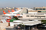
Guarulhos International Airport
São Paulo/Guarulhos – Governador André Franco Montoro International Airport , formerly called Cumbica Airport after the district where it is located and the Air Force Base that still exists at the airport complex, is the main airport serving São Paulo, Brazil. It is located in the adjoining...
(IATA: GRU) for domestic and international flights and Congonhas-São Paulo Airport (IATA: CGH) for domestic flights. There's also a small airport known as Campo de Marte north of the Old Center for small, private aircraft and helicopters. Campo de Marte also hosts the Ventura Goodyear Blimp.
Congonhas Airport operates domestic and regional flights, mainly to Rio de Janeiro
Rio de Janeiro
Rio de Janeiro , commonly referred to simply as Rio, is the capital city of the State of Rio de Janeiro, the second largest city of Brazil, and the third largest metropolitan area and agglomeration in South America, boasting approximately 6.3 million people within the city proper, making it the 6th...
, Belo Horizonte
Belo Horizonte
Belo Horizonte is the capital of and largest city in the state of Minas Gerais, located in the southeastern region of Brazil. It is the third largest metropolitan area in the country...
and Brasília
Brasília
Brasília is the capital city of Brazil. The name is commonly spelled Brasilia in English. The city and its District are located in the Central-West region of the country, along a plateau known as Planalto Central. It has a population of about 2,557,000 as of the 2008 IBGE estimate, making it the...
. Campo de Marte airport handles some private and small-sized airplanes. Guarulhos International Airport, also known to São Paulo dwellers as "Cumbica", is located 25 km North East of the city centre, in the neighbouring city of Guarulhos
Guarulhos
Guarulhos is the second largest city in the Brazilian state of São Paulo and a suburb of São Paulo city itself. In the last few years it has outgrown Campinas. The population in 2006 is 1,283,253, the density is 4,035.26 inh./km² and the area is 318 km²...
. Guarulhos airport operates both domestic and international flights.
On 17 July 2007 the worst airline accident in Brazil's history occurred at Congonhas airport, blamed on rain and a shortended runway. 199 people from the plane and on the ground died. Following the accident, pilots refused to land under rainy conditions and the Brazilian President signed an act so that ticket sales for flights to the airport be stopped. Aviation throughout the entire country reached a crisis state, which is slowly being overcome by new safety measures such as the introduction of a grooved pavement in the runways.
In 2006, about 34.3 million people went through the city's airports (mainly from Congonhas and Guarulhos International Airport, the only two operating commercial flights). Infraero, Brazil's main aviation authority, estimates that with the remodelling of Guarulhos Airport, São Paulo's airports will be able to handle about 45 million passengers a year within the next five years. There are also plans to expand the Viracopos-Campinas International Airport at Campinas
Campinas
Campinas is a city and municipality located in the coastal interior of the state of São Paulo, Brazil. is the administrative center of the meso-region of the same name, with 3,783,597 inhabitants as of the 2010 Census, consisting of 49 cities....
, a city about 90 km North of São Paulo.
São Paulo has allegedly one of the highest per capita helicopter ownership in the world. The owners are an elite wealthy class who take advantage of around one hundred helipads and heliports to conveniently avoid heavy traffic.
Main Brazilian airlines
- TAM Airlines
- Gol Transportes AéreosGol Transportes AéreosGol Transportes Aéreos is a Brazilian airline based in Comandante Lineu Gomes Square, São Paulo City, Brazil....
- VarigVarigVARIG was the first airline founded in Brazil, in 1927. From 1965 until 1990 it was Brazil's leading and almost only international airline...
- OceanAirOceanAirAvianca Brazil , trademark of Oceanair Linhas Aéreas S/A, is a Brazilian airline based in São Paulo, Brazil. It operates passenger services from 23 destinations. Its main base is Guarulhos International Airport, São Paulo. Even though the legal name of the airline remains OceanAir, Avianca ...
Heliports
São Paulo has the second largest fleet of helicopters in the world, losing only to New York, are 420 helicopters in the city vehicle. Modern is one of the symbols of the so-called top of the circle makes the mainland economy and faster, being increasingly used by the richest of the city to escape major congestion. There are 260 heliports in São Paulo.There are many companies of aerio taxi in the city, more used by executives to travel in the fast axis Rio-São Paulo.
Motorways
Roads
Many Brazilian highways pass through or start in São Paulo, such as BR-116
BR-116
BR-116 is a federal highway of Brazil. One of the most important highways in all of Brazil and one of its longest, the 4385 kilometre road connects Fortaleza to Jaguarão....
, Rodovia dos Bandeirantes
Rodovia dos Bandeirantes
Rodovia Bandeirantes is a highway in the state of São Paulo, Brazil.Once the traffic capacity of Anhangüera Highway was exceeded in the 1960s, the state government decided to built another highway, with a much higher capacity and modern design, directly connecting São Paulo City to Jundiaí,...
, Rodovia Raposo Tavares
Rodovia Raposo Tavares
Rodovia Raposo Tavares is the longest highway in the state of São Paulo, Brazil, with 664 km.The highway starts in the city of São Paulo and continues westward, serving the main cities of Cotia, Vargem Grande Paulista, São Roque, Sorocaba, Itapetininga, Angatuba, Ourinhos, Assis, Presidente...
, the Rodovia Anhangüera
Rodovia Anhangüera
Rodovia Anhangüera is a highway in the state of São Paulo, Brazil. It is one of the country's busiest transportation corridors...
, Rodovia dos Imigrantes
Rodovia dos Imigrantes
Rodovia dos Imigrantes is a highway in the state of São Paulo, Brazil.The highway connects the city of São Paulo to the Atlantic coast and with the seaside cities of São Vicente and Praia Grande. It follows the route of Rodovia Anchieta and is also one of Brazil's busiest highways, particularly on...
, Rodovia Castelo Branco
Rodovia Castelo Branco
Rodovia Presidente Castelo Branco is a tollway in the state of São Paulo, Brazil. It was first opened on November 10, 1968, by, then, the Governor of the state of São Paulo, Abreu Sodré...
, and Via Dutra.
Rodoanel
The Rodoanel Mario CovasRodoanel Mário Covas
Rodoanel Mário Covas is the planned Greater São Paulo Beltway, around the largest megalopolis of Brazil. Upon its completion, it will have a length of , with a radius of approximately from the geographical center of the city...
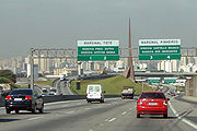
(SP-21) (also known as Rodoanel Metropolitano de São Paulo or simply Rodoanel) is a motorway being built around the center of the metropolitan region of São Paulo in an attempt to alleviate the intense traffic of trucks along the city's two riverside highways (Pinheiros
Marginal Pinheiros
Marginal Pinheiros is a section of this highway that runs through the city of São Paulo, Brazil. The name of this section comes from the fact that each way of the expressway runs near a different waterfront of the Pinheiros River...
and Tietê
Marginal Tietê
Marginal Tietê is a section of this highway that runs through the city of São Paulo, Brazil. The name of this section comes from the fact that each way of the expressway runs near a different waterfront of the Tietê River...
).
The Rodoanel is being constructed as a multi-lane, limited-access freeway, with large sections to be built in unoccupied regions, along the edge of forests, or close to residential areas, in an effort to prevent squatting and development in environmentally sensitive areas along the route. Nevertheless, the announcement of the planned route provoked intense property speculation in these regions. Construction is being carried out in four phases - west, south, east and north. As of mid-2010, the West and south section have been completed. The beginning of construction on the east section is planned for February 2011. Due to rougher terrain and environmental concerns, there is no projected date for the initiation of construction on the northern section.
IMPORTANT INFORMATION; If you want to drive a car in the city of Sao Paulo, please note that during the week you have to respect a special schedule according to your car's license, example:
on Mondays, the car's licenses ending with the numbers '1 or 2' can not be used;
on Tuesdays, you can not drive your car if it ends with '3 or 4", and so on, until Fridays, when the finals "9 or 0" are forbidden. If you don't obey that rule you will have to pay a fine.
Roads interconnected
| West (2002) | South (2010) | East (2014) | North (2018) |
 SP-332 SP-332 |
 Imigrantes ImigrantesRodovia dos Imigrantes Rodovia dos Imigrantes is a highway in the state of São Paulo, Brazil.The highway connects the city of São Paulo to the Atlantic coast and with the seaside cities of São Vicente and Praia Grande. It follows the route of Rodovia Anchieta and is also one of Brazil's busiest highways, particularly on... |
 Ayrton Senna Ayrton SennaRodovia Ayrton Senna Rodovia Ayrton Senna da Silva , is a highway in the state of São Paulo, Brazil.... |
 Fernão Dias Fernão DiasRodovia Fernão Dias The Rodovia Fernão Dias is a federal highway which runs in the Brazilian states of São Paulo and southern region of Minas Gerais... |
 Bandeirantes BandeirantesRodovia dos Bandeirantes Rodovia Bandeirantes is a highway in the state of São Paulo, Brazil.Once the traffic capacity of Anhangüera Highway was exceeded in the 1960s, the state government decided to built another highway, with a much higher capacity and modern design, directly connecting São Paulo City to Jundiaí,... |
 Anchieta AnchietaRodovia Anchieta Rodovia Anchieta is a highway connection between São Paulo and the Atlantic coast, the cities of Cubatão and Santos, in Brazil... |
 Dutra DutraRodovia Presidente Dutra The Rodovia Presidente Dutra, , colloquially known as Via Dutra is a federal highway which runs through the eastern part of the state of São Paulo and southwestern region of the state Rio de Janeiro... |
|
 Anhangüera AnhangüeraRodovia Anhangüera Rodovia Anhangüera is a highway in the state of São Paulo, Brazil. It is one of the country's busiest transportation corridors... |
SP-66 | ||
 Castelo Branco Castelo BrancoRodovia Castelo Branco Rodovia Presidente Castelo Branco is a tollway in the state of São Paulo, Brazil. It was first opened on November 10, 1968, by, then, the Governor of the state of São Paulo, Abreu Sodré... |
|||
 Raposo Tavares Raposo TavaresRodovia Raposo Tavares Rodovia Raposo Tavares is the longest highway in the state of São Paulo, Brazil, with 664 km.The highway starts in the city of São Paulo and continues westward, serving the main cities of Cotia, Vargem Grande Paulista, São Roque, Sorocaba, Itapetininga, Angatuba, Ourinhos, Assis, Presidente... |
|||
| Régis Bittencourt Rodovia Régis Bittencourt Rodovia Régis Bittencourt is a section of the BR-116 that connects the cities of São Paulo and Curitiba, Brazil. It is considered one of the most dangerous highways of Brazil, due to the high number of accidents. Sometimes it is even nicknamed "Rodovia da Morte" . It also leads the number of... |