
Transport in San Marino
Encyclopedia
Railway
World War II
World War II, or the Second World War , was a global conflict lasting from 1939 to 1945, involving most of the world's nations—including all of the great powers—eventually forming two opposing military alliances: the Allies and the Axis...
, San Marino had a railway network consisting of a single line, connecting the country with the Italian rail network at Rimini railway station
Rimini railway station
Rimini railway station is the main station serving the city and comune of Rimini, in the region of Emilia-Romagna, northern Italy. Opened in 1861, it forms part of the Bologna–Ancona railway, and is also a terminus of a secondary railway linking Rimini with Ravenna and Modena.The station is...
. Due to difficulties in accessing the capital, San Marino City
San Marino, San Marino
The City of San Marino, also known simply as San Marino, is the capital city of the Republic of San Marino on the Italian peninsula, near the Adriatic Sea. The city has a population of 4,493. It is on the western slopes of San Marino's highest point, Monte Titano.-Geography:Although the capital,...
(which has a mountain-top location), the terminus station was to be located at the village of Valdragone
Valdragone
Valdragone is a village in central San Marino. It belongs to the castello of Borgo Maggiore.-Geography:The village is divided into two areas: Valdragone di Sopra and Valdragone di Sotto...
. However with a joint effort between San Marino and Italy the railway was extended to reach the capital through a steep and winding track comprising many tunnels. The railway was opened on 12 June 1932.
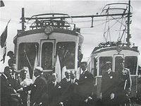
It was an advanced system for its time, being an electric railway, powered by overhead electric cables
Overhead lines
Overhead lines or overhead wires are used to transmit electrical energy to trams, trolleybuses or trains at a distance from the energy supply point...
. The trains drew power from these cables by means of a pantograph
Pantograph (rail)
A pantograph for rail lines is a hinged electric-rod device that collects electric current from overhead lines for electric trains or trams. The pantograph typically connects to a one-wire line, with the track acting as the ground wire...
system.
The tracks were narrow gauge, which offered advantages in terms of costs and ease of construction given the geographical features of the route, but made the railway incompatible with the Italian network.
The train carriages had a distinctive appearance, being liveried in the national colours of San Marino, blue and white layered horizontally; the service offered first class and third class seats.
There were 17 tunnels, all located within Sammarinese territory, ranging from about 50 m to 800 m in length.
The railway was well built and well used, and in all probability would have been a long-term feature of Sammarinese public transport, but it was almost completely destroyed during the fighting in this region during World War II
World War II
World War II, or the Second World War , was a global conflict lasting from 1939 to 1945, involving most of the world's nations—including all of the great powers—eventually forming two opposing military alliances: the Allies and the Axis...
. Today there is no operational railway in San Marino, but many disused artifacts such as bridges, tunnels and stations are still well visible, and in some cases have been refurbished and converted to parks, public footpaths
Rail trail
A rail trail is the conversion of a disused railway easement into a multi-use path, typically for walking, cycling and sometimes horse riding. The characteristics of former tracks—flat, long, frequently running through historical areas—are appealing for various development. The term sometimes also...
or traffic routes.
Most of the tunnels are well preserved today and three of them have been checked for safety, provided with lighting and opened for pedestrian
Rail trail
A rail trail is the conversion of a disused railway easement into a multi-use path, typically for walking, cycling and sometimes horse riding. The characteristics of former tracks—flat, long, frequently running through historical areas—are appealing for various development. The term sometimes also...
use. Most of the others have either been closed for safety reasons or purchased privately for storage. Inside the last tunnel, about 500 m long, closest to the former San Marino station, some of the train coaches once used are still being preserved.
Some of the bridges and other constructions used by the former railway have become well loved landmarks, especially the "Fontevecchia" bridge, set in a pleasant countryside location.
Dogana's station is now the centre of a large public park. Other stations have either been converted to private homes or demolished.
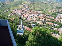
Aerial tramway
Aerial tramway
An aerial tramway , cable car , ropeway or aerial tram is a type of aerial lift which uses one or two stationary ropes for support while a third moving rope provides propulsion...
connecting the city
City
A city is a relatively large and permanent settlement. Although there is no agreement on how a city is distinguished from a town within general English language meanings, many cities have a particular administrative, legal, or historical status based on local law.For example, in the U.S...
of San Marino
San Marino, San Marino
The City of San Marino, also known simply as San Marino, is the capital city of the Republic of San Marino on the Italian peninsula, near the Adriatic Sea. The city has a population of 4,493. It is on the western slopes of San Marino's highest point, Monte Titano.-Geography:Although the capital,...
on top of Monte Titano
Monte Titano
Monte Titano is a mountain of the Apennines and the highest peak in San Marino. It stands at above sea level and is located immediately to the east of the capital, San Marino. It was inscribed as a UNESCO World Heritage Site in 2008 under the combined title "San Marino Historic Centre and Mount...
with Borgo Maggiore
Borgo Maggiore
Borgo Maggiore is one of the 9 communes or "castelli" of San Marino. It lies at the foot of Monte Titano and has a population of 5,992 , making it the second largest town of San Marino, after Dogana.-Geography:...
, a major town in the republic, with the second largest population of any Sammarinese settlement. Indeed, for the tourist visitor the aerial tramway gives the best available views of Borgo Maggiore, as the cars sweep low over the rooftops of the main town square. From here a further connection is available to the nation's largest settlement, Dogana
Dogana
Dogana may be:*Dogana, a town of San Marino*Dogana, means customs in Italian and can refer to :** Individual Custom Houses such as that of Venice**Agenzia delle Dogane , the Italian customs organisation...
, by means of local bus service.
Two aerial tramway cars, known as gondolas, and numbered '1' and '2', operate in opposition on a cable, and a service is provided at roughly fifteen minute intervals throughout the day. A third vehicle is available on the system, being a service car for the use of engineers maintaining the tramway.
The upper station of the aerial tramway serves no other purpose (although it is situated close to a tourist information office). However, the lower station in Borgo Maggiore has a number of retail and catering outlets situated within its overall structure.
Taxi and private road vehicles
There are 220 km of highwayHighway
A highway is any public road. In American English, the term is common and almost always designates major roads. In British English, the term designates any road open to the public. Any interconnected set of highways can be variously referred to as a "highway system", a "highway network", or a...
s in the country, the main road being the San Marino Superhighway. Roads are well used by private car drivers. Sammarinese authorities license private vehicles with distinctive licence plates which are white with blue figures, usually a letter followed by up to four numbers. To the left of these figures is printed the national Coat of Arms of San Marino. Many vehicles also carry the international vehicle identification code (in black on a white oval sticker), which is "RSM". Since 2004 custom licence plates have also become available.
A limited licensed taxi service operates nationwide. There are seven licensed taxi operating companies in the republic, and Italian taxis regularly operate within San Marino when carrying passengers picked up in Italian territory.
Buses
There is a regular busBus
A bus is a road vehicle designed to carry passengers. Buses can have a capacity as high as 300 passengers. The most common type of bus is the single-decker bus, with larger loads carried by double-decker buses and articulated buses, and smaller loads carried by midibuses and minibuses; coaches are...
service between Rimini
Rimini
Rimini is a medium-sized city of 142,579 inhabitants in the Emilia-Romagna region of Italy, and capital city of the Province of Rimini. It is located on the Adriatic Sea, on the coast between the rivers Marecchia and Ausa...
and the city of San Marino, popular with both tourists and tourist industry workers commuting to San Marino from Italy. This service stops at approximately twenty advertised locations in Rimini and within San Marino, with its two terminus stops at Rimini railway station and San Marino coach station, respectively.
San Marino also has its own small local bus system within the republic. This can be a useful means of transport for a visitor staying more than one day in San Marino, and therefore having the opportunity to explore the wider country and some its smaller communities. It is worth noting that tourists who are resident in a Sammarinese hotel are usually entitled to a discount on local bus fares (though not on the international service to Rimini, Italy).
Air transport
There is a small airfield located 43.94942°N 12.51098°W in DomagnanoDomagnano
Domagnano is a municipality in San Marino. It has 2,865 inhabitants in an area of 6.62 km².-Geography:It borders the San Marino municipalities Faetano, Borgo Maggiore, Serravalle and the Italian municipality Coriano.-History:...
right next to the border; there is also an international heliport
Heliport
A heliport is a small airport suitable only for use by helicopters. Heliports typically contain one or more helipads and may have limited facilities such as fuel, lighting, a windsock, or even hangars...
located in Borgo Maggiore. Most tourists who arrive by air land at Rimini's international airport in Italy
Italy
Italy , officially the Italian Republic languages]] under the European Charter for Regional or Minority Languages. In each of these, Italy's official name is as follows:;;;;;;;;), is a unitary parliamentary republic in South-Central Europe. To the north it borders France, Switzerland, Austria and...
, and then make the transfer by bus.