
Transport in Ethiopia
Encyclopedia
Transportation infrastructure in Ethiopia has been neglected for decades, but is now a priority of the government of Ethiopia. Most of the roads and railways are now under construction, and will be completed between 2011 and 2014. Over a third of the funding for asphalt
and gravel
roads is being covered by the Ethiopian Government which is a considerable shift in recent years financial scheme. About 10 years back the International Development Agency, the European Union
and Japan
. had supported the finance by allocating about 90% required.
The Ethiopian government has begun second part of the Road Sector Development Program, which was completed in 2007. This will involve the upgrading or construction of over 7,500 km of roads, with the goal of improving the average road density for Ethiopia to 35 km per 1000 km2, and reduce the proportion of the country area that is more than 5 km from an all-weather road from 75% to 70%.
As of 2006, Ethiopia only had one expressway—the Addis Ababa Ring Road. This is a four-lane limited-access divided highway, which forms a beltway around the capital. Some portions are still yet to be completed. The majority of its interchanges consist of roundabouts. Pedestrian bridges were constructed every kilometer, to reduce the risk of accidents. While not built to expressway standards, many roads in Addis Ababa and other cities can be considered dual carriageways and have up to four lanes in each direction with hardly any intersections.
But the Ethiopian Roads Authority and China Communications Construction Consultancy is going to build a new six-lane expressway between Addis Ababa and Adama. The expressway will be 80 km long, will shorten the Addis to Adama distance by 20 km. To build this expressway will cost Ethiopia US$350 million. The expressway will begin at Ayat, Addis Ababa and end in north part of Adama. 150 km/h is the limited speed at the expressway, the journey will take about 30–40 minutes. The expressway will be completed in 2014.
Ethiopia has spent over 600 billion birr
(USD $50 billion, €30 billion) in infrastructure since 1990, according to the Ethiopian government.
Major roads include:
No 1: north from Addis Ababa 891 km via Dessie
to Adigrat
, from Dessie to Weldiya
. Designated part of the Ndjamena-Djibouti
Trans-African Highway 6 (TAH 6)
No 2: east from Dessie 482 km to Aseb. Designated part of the Ndjamena-Djibouti TAH 6
No 3: north from Addis Ababa across the Blue Nile
at Dejen
and again at Bahir Dar
east around Lake Tana
979 km via Gondar
and Aksum to Adwa
. Designated part of the Cairo-Cape Town
Trans-African Highway 4 (TAH 4) from Addis Ababa to Gondar, and part of TAH 6 from Wereta
to Gondar
No 4: east from Addis Ababa 542 km via Dire Dawa
to Jijiga
No 5: west from Addis Ababa 322 km to Nekemte
No 6: south from Addis Ababa 797 km via Shashamene to Moyale
. Designated part of TAH 4;
No 7: south-west from Addis Ababa 336 km via Waliso
(Ghion) and Jimma
to Bonga
No 8: south from Nazret 193 km via Asella
and Dodola
to Mogadishu
No 18: north from Awash
on No 4 305 km to Mille on No 2
No 30: south-east from Jijiga 696 km across the Ogaden
to the Shabelle valley
No 43: south-west from Nekemte 226 km to Metu
No 44: south-east from Shashamene 308 km to Dolo Odo
(Doolow)
using the ports of Asseb and Massawa
; since the Eritrean-Ethiopian War
, Ethiopia has used the port of Djibouti
for nearly all of its imports. Only one river, the Baro
is used for transport.
12 ships (with a volume of or over) totaling / (1999 est.); 9 ships (with a volume of or over) / (2003 est.)
ships by type:
cargo ship
7; container ship
1; petroleum tanker
1; roll-on/roll-off ship 3 (1999 est.), 1 (2003 est.)
, the national carrier, Ethiopian Airlines
, flew to numerous African, Asian, and European cities, and had sole rights on domestic air traffic. In 2003, about 1.147 million passengers were carried on domestic and international flights.
Paved runways
total:
14
over 3,047 m:
3
2,438 to 3,047 m:
5
1,524 to 2,437 m:
5
914 to 1,523 m:
1 (2003 est.)
Unpaved runways
total:
68
over 3,047 m:
3
2,438 to 3,047 m:
2
1,524 to 2,437 m:
13
914 to 1,523 m:
27
under 914 m:
23 (2003 est.)
Asphalt
Asphalt or , also known as bitumen, is a sticky, black and highly viscous liquid or semi-solid that is present in most crude petroleums and in some natural deposits, it is a substance classed as a pitch...
and gravel
Gravel
Gravel is composed of unconsolidated rock fragments that have a general particle size range and include size classes from granule- to boulder-sized fragments. Gravel can be sub-categorized into granule and cobble...
roads is being covered by the Ethiopian Government which is a considerable shift in recent years financial scheme. About 10 years back the International Development Agency, the European Union
European Union
The European Union is an economic and political union of 27 independent member states which are located primarily in Europe. The EU traces its origins from the European Coal and Steel Community and the European Economic Community , formed by six countries in 1958...
and Japan
JICA
KF3 is a kart racing class for top drivers aged 12 to 15 .This class used to be called Junior Intercontinental A and has changed since January 2007 when CIK-FIA decided to replace the 100 cc air-cooled two-stroke engines with 125 cc Touch-and-Go water-cooled two-stroke...
. had supported the finance by allocating about 90% required.
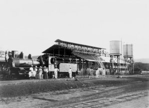
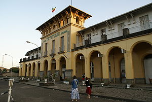
Railways
- 681 km (EthiopiaEthiopiaEthiopia , officially known as the Federal Democratic Republic of Ethiopia, is a country located in the Horn of Africa. It is the second-most populous nation in Africa, with over 82 million inhabitants, and the tenth-largest by area, occupying 1,100,000 km2...
n segment of the Addis Ababa - Djibouti RailwayImperial Railway Company of EthiopiaRail transport in Ethiopia currently consists only of a line from Djibouti to Dire Dawa. The line continues from Dire Dawa to Addis Ababa, but is no longer operational...
), all narrow gaugeMetre gaugeMetre gauge refers to narrow gauge railways and tramways with a track gauge of . In some African, American and Asian countries it is the main gauge. In Europe it has been used for local railways in France, Germany, and Belgium, most of which were closed down in mid 20th century. Only in Switzerland...
(1902–2010) - note: At present the railway is under joint control of Djibouti and Ethiopia, but negotiations are underway to privatize this transport utility.
- 2 November 2006 - Ineco Spt of Spain was named the preferred choice for supervision and administration of rehabilitation work on the 781 km Ethio-Djibouti Railway for €2.2 million. Consta - an Italian company - will undertake the actual reconstruction at a cost of €40 million (about R360m). ComazarComazarComazar is a company that operates railways in Africa. Its stock is majority owned by the French investment group Bolloré.Comazar was founded by Eric Peiffer and Patrick Claes in conjunction with Transnet and Transurb Consult in 1995.The headquarters are in Johannesburg.- Related organizations...
of South Africa has been awarded the 25-year concession. Rails are to be upgraded from 20 kg/m to 40 kg/m, to carry substantially increased loads. A fleet of new locomotives and freight wagons will be brought in by the concessionaire.
- In 2008 a concrete sleeperConcrete sleeperA concrete sleeper is a railroad tie made out of steel reinforced concrete.-History:Concrete sleepers were first made in Germany in 1906 for use between Nuremberg and Bamberg.-Types:...
plant was constructed in Dire DawaDire DawaDire Dawa is one of two chartered cities in Ethiopia . This chartered city is divided administratively into two woredas, the city proper and the non-urban woreda of Gurgura....
.
- In September 2009 ERC signed a deal with China Railway Engineering Corporation for it to build the new Addis Ababa light railwayLight railwayLight railway refers to a railway built at lower costs and to lower standards than typical "heavy rail". This usually means the railway uses lighter weight track, and is more steeply graded and tightly curved to avoid civil engineering costs...
transit.
Highways
As the first part of a 10-year Road Sector Development Program, between 1997 and 2002 the Ethiopian government began a sustained effort to improve its infrastructure of roads. As a result, as of 2002 Ethiopia has a total (Federal and Regional) 33,297 km of roads, both paved and gravel. The share of Federally managed roads in good quality improved from 14% in 1995 to 31% in 2002 as a result of this program, and to 89% in 2009 the road density increased from 21 km per 1000 km2 (in 1995) to 889 km; per 1000 km2 (in 2009) however, this is much greater than the average of 50 km per 1000 km2 for Africa.The Ethiopian government has begun second part of the Road Sector Development Program, which was completed in 2007. This will involve the upgrading or construction of over 7,500 km of roads, with the goal of improving the average road density for Ethiopia to 35 km per 1000 km2, and reduce the proportion of the country area that is more than 5 km from an all-weather road from 75% to 70%.
As of 2006, Ethiopia only had one expressway—the Addis Ababa Ring Road. This is a four-lane limited-access divided highway, which forms a beltway around the capital. Some portions are still yet to be completed. The majority of its interchanges consist of roundabouts. Pedestrian bridges were constructed every kilometer, to reduce the risk of accidents. While not built to expressway standards, many roads in Addis Ababa and other cities can be considered dual carriageways and have up to four lanes in each direction with hardly any intersections.
But the Ethiopian Roads Authority and China Communications Construction Consultancy is going to build a new six-lane expressway between Addis Ababa and Adama. The expressway will be 80 km long, will shorten the Addis to Adama distance by 20 km. To build this expressway will cost Ethiopia US$350 million. The expressway will begin at Ayat, Addis Ababa and end in north part of Adama. 150 km/h is the limited speed at the expressway, the journey will take about 30–40 minutes. The expressway will be completed in 2014.
Ethiopia has spent over 600 billion birr
Birr
Birr is a town in County Offaly, Ireland. Once called Parsonstown, after the Parsons family who were local landowners and hereditary Earls of Rosse. It is also a parish in the Roman Catholic Diocese of Killaloe....
(USD $50 billion, €30 billion) in infrastructure since 1990, according to the Ethiopian government.
- total (Regional and Federal): 101,359 km (2009)
- asphalt: 90,336 km (2009) (89 % of the roads in Ethiopia is asphalt)
- gravel: 11,023 km (2009) (11 % of the roads in Ethiopia is gravel)
- maintained by Regional government: 86,580 km (2009)
Major roads include:
No 1: north from Addis Ababa 891 km via Dessie
Dessie
Dessie is a city and a woreda in north-central Ethiopia. Located on the Addis Ababa - Asmara highway in the Debub Wollo Zone of the Amhara Region, this city has a latitude and longitude of with an elevation between 2,470 and 2,550 meters above sea level.Dessie has postal service , and telephone...
to Adigrat
Adigrat
Adigrat is a city in the Tigray Region of Ethiopia. Located in the Misraqawi Zone at longitude and latitude with an elevation of 2457 meters above sea level, below a high ridge to the west, Adigrat is the last important Ethiopian city south of the border with Eritrea, and is considered to be a...
, from Dessie to Weldiya
Weldiya
Weldiya is a hillside market town, capital of the Semien Wollo Zone, and woreda in northern Ethiopia. Located north of Dessie and southeast of Lalibela in the Amhara Region, this town has a latitude and longitude of and an elevation of 2112 meters above sea level.A notable landmark is the church...
. Designated part of the Ndjamena-Djibouti
Ndjamena-Djibouti Highway
The Ndjamena-Djibouti Highway is Trans-African Highway 6 in the transcontinental road network being developed by the United Nations Economic Commission for Africa , the African Development Bank , and the African Union, connecting the Sahelian region to the Indian Ocean port of Djibouti in the...
Trans-African Highway 6 (TAH 6)
No 2: east from Dessie 482 km to Aseb. Designated part of the Ndjamena-Djibouti TAH 6
No 3: north from Addis Ababa across the Blue Nile
Blue Nile
The Blue Nile is a river originating at Lake Tana in Ethiopia. With the White Nile, the river is one of the two major tributaries of the Nile...
at Dejen
Dejen
Dejen is a town in west-central Ethiopia. Located in the Misraq Gojjam Zone of the Amhara Region on the edge of the canyon of the Abay, it has a latitude and longitude of and an elevation between 2421 and 2490 meters above sea level. It is the administrative center of Dejen woreda.Between 1954...
and again at Bahir Dar
Bahir Dar
Bahir Dar is a city in north western Ethiopia. It is the capital of the Amhara Region .Administratively, Bahir Dar is considered a Special Zone, placing it midway between Addis Ababa and Dire Dawa which are organized as chartered cities , and cities like Debre Marqos and Dessie, which are...
east around Lake Tana
Lake Tana
Lake Tana is the source of the Blue Nile and is the largest lake in Ethiopia...
979 km via Gondar
Gondar
Gondar or Gonder is a city in Ethiopia, which was once the old imperial capital and capital of the historic Begemder Province. As a result, the old province of Begemder is sometimes referred to as Gondar...
and Aksum to Adwa
Adwa
Adwa is a market town in northern Ethiopia, and best known as the community closest to the decisive Battle of Adowa fought in 1896 with Italian troops. Notably, Ethiopian soldiers won the battle, thus being the only African nation to thwart European colonialism...
. Designated part of the Cairo-Cape Town
Cairo-Cape Town Highway
The Cairo-Cape Town Highway is Trans-African Highway 4 in the transcontinental road network being developed by the United Nations Economic Commission for Africa , the African Development Bank , and the African Union...
Trans-African Highway 4 (TAH 4) from Addis Ababa to Gondar, and part of TAH 6 from Wereta
Wereta
Wereta is a town in northern Ethiopia. Located in the Debub Gondar Zone of the Amhara Region, east of Lake Tana and south of Addis Zemen, this town has a latitude and longitude of with an elevation of 1828 meters above sea level...
to Gondar
No 4: east from Addis Ababa 542 km via Dire Dawa
Dire Dawa
Dire Dawa is one of two chartered cities in Ethiopia . This chartered city is divided administratively into two woredas, the city proper and the non-urban woreda of Gurgura....
to Jijiga
Jijiga
Jijiga is a city in eastern Ethiopia and the capital of the Somali Region of that country. Located in the Jijiga Zone approximately 80 km east of Harar and 60 km west of the border with Somalia, this city has a latitude and longitude of with an elevation of 1,609 meters above sea...
No 5: west from Addis Ababa 322 km to Nekemte
Nekemte
Nekemte is a market town in western Ethiopia. Located in the Misraq Welega Zone of the Oromia Region , Nekemte has a latitude and longitude of and an elevation of 2,088 meters....
No 6: south from Addis Ababa 797 km via Shashamene to Moyale
Moyale
Moyale is a market town on the border of Ethiopia and Kenya, which is split between the two countries: the larger portion is in Ethiopia , and the smaller is in Kenya . There are four disputed locations within the Moyale district between the Somali and Oromo regions...
. Designated part of TAH 4;
No 7: south-west from Addis Ababa 336 km via Waliso
Waliso
Waliso is a town in central Ethiopia. Located in the Debub Mirab Shewa Zone of the Oromia Region, 115km southwest of Addis Ababa, it has a latitude and longitude of with an elevation of 2063 meters above sea level...
(Ghion) and Jimma
Jimma
Jimma, also Jima, is the largest city in southwestern Ethiopia. Located in the Jimma Zone of the Oromia Region, it has a latitude and longitude of . The town was the capital of Kaffa Province until the province was dissolved. Prior to the 2007 census, Jimma was reorganized administratively as a...
to Bonga
Bonga
Bonga is a town in southwestern Ethiopia. Located southwest of Jimma in the Keficho Shekicho Zone of the Southern Nations, Nationalities and Peoples Region upon a hill in the upper Barta valley, it has a latitude and longitude of with an elevation of 1,714 meters above sea level...
No 8: south from Nazret 193 km via Asella
Asella
Asella also Asela is a city in central Ethiopia. Located in the Arsi Zone of the Oromia Region about 175 kilometers from Addis Ababa, this city has a latitude and longitude of , with an elevation of 2430 meters. Asella hosts an airport...
and Dodola
Dodola, Ethiopia
Dodola is a town in southeastern Ethiopia. Located in the Bale Zone of the Oromia Region, this town has a latitude and longitude of , with an elevation ranging from 2362 to 2493 meters above sea level. It is the administrative center of Dodola woreda....
to Mogadishu
Mogadishu
Mogadishu , popularly known as Xamar, is the largest city in Somalia and the nation's capital. Located in the coastal Benadir region on the Indian Ocean, the city has served as an important port for centuries....
No 18: north from Awash
Awash
Awash is a market town in central Ethiopia. Located in Administrative Zone 3 of the Afar Region, above a gorge on the Awash River, after which the town is named, the town lies on the Addis Ababa - Djibouti Railway, which crosses the gorge by a bridge there...
on No 4 305 km to Mille on No 2
No 30: south-east from Jijiga 696 km across the Ogaden
Ogaden
Ogaden is the name of a territory comprising the southeastern portion of the Somali Regional State in Ethiopia. The inhabitants are predominantly ethnic Somali and Muslim. The title "Somali Galbeed", which means "Western Somalia," is often preferred by Somali irredentists.The region, which is...
to the Shabelle valley
No 43: south-west from Nekemte 226 km to Metu
Metu
Metu is a market town in southwestern Ethiopia. Located in the Illubabor Zone of the Oromia Region along the Sor River, this town has a latitude and longitude of and an altitude of 1605 meters...
No 44: south-east from Shashamene 308 km to Dolo Odo
Dolo Odo
Dolo Odo is one of the 47 woredas in the Somali Region of Ethiopia. Part of the Liben Zone, Dolo Odo is located in the angle formed by the confluence of the Ganale Dorya with the Dawa River, and bordered to the west by Moyale, to the northwest by Liben, on the north and east by Afder Zone, and on...
(Doolow)
- WeretaWeretaWereta is a town in northern Ethiopia. Located in the Debub Gondar Zone of the Amhara Region, east of Lake Tana and south of Addis Zemen, this town has a latitude and longitude of with an elevation of 1828 meters above sea level...
-Woldia: Designated part of the Ndjamena-Djibouti HighwayNdjamena-Djibouti HighwayThe Ndjamena-Djibouti Highway is Trans-African Highway 6 in the transcontinental road network being developed by the United Nations Economic Commission for Africa , the African Development Bank , and the African Union, connecting the Sahelian region to the Indian Ocean port of Djibouti in the...
(TAH 6)
Ports and harbours
None. Ethiopia is landlocked and was by agreement with EritreaEritrea
Eritrea , officially the State of Eritrea, is a country in the Horn of Africa. Eritrea derives it's name from the Greek word Erethria, meaning 'red land'. The capital is Asmara. It is bordered by Sudan in the west, Ethiopia in the south, and Djibouti in the southeast...
using the ports of Asseb and Massawa
Massawa
Massawa, also known as Mitsiwa Massawa, also known as Mitsiwa Massawa, also known as Mitsiwa (Ge'ez ምጽዋዕ , formerly ባጽዕ is a city on the Red Sea coast of Eritrea. An important port for many centuries, it was ruled by a succession of polities, including the Axumite Empire, the Umayyad Caliphate,...
; since the Eritrean-Ethiopian War
Eritrean-Ethiopian War
The Eritrean–Ethiopian War took place from May 1998 to June 2000 between Ethiopia and Eritrea, forming one of the conflicts in the Horn of Africa...
, Ethiopia has used the port of Djibouti
Djibouti
Djibouti , officially the Republic of Djibouti , is a country in the Horn of Africa. It is bordered by Eritrea in the north, Ethiopia in the west and south, and Somalia in the southeast. The remainder of the border is formed by the Red Sea and the Gulf of Aden at the east...
for nearly all of its imports. Only one river, the Baro
Baro River
The Baro River is a river in southwestern Ethiopia, which defines part of Ethiopia's border with South Sudan. From its source in the Ethiopian Highlands it flows west for to join the Pibor River...
is used for transport.
Merchant marine
Total:12 ships (with a volume of or over) totaling / (1999 est.); 9 ships (with a volume of or over) / (2003 est.)
ships by type:
cargo ship
Cargo ship
A cargo ship or freighter is any sort of ship or vessel that carries cargo, goods, and materials from one port to another. Thousands of cargo carriers ply the world's seas and oceans each year; they handle the bulk of international trade...
7; container ship
Container ship
Container ships are cargo ships that carry all of their load in truck-size intermodal containers, in a technique called containerization. They form a common means of commercial intermodal freight transport.-History:...
1; petroleum tanker
Oil tanker
An oil tanker, also known as a petroleum tanker, is a merchant ship designed for the bulk transport of oil. There are two basic types of oil tankers: the crude tanker and the product tanker. Crude tankers move large quantities of unrefined crude oil from its point of extraction to refineries...
1; roll-on/roll-off ship 3 (1999 est.), 1 (2003 est.)
Airports
There were an estimated 84 airports in 2005, only 14 of which had paved runways as of 2005. The Addis Ababa Airport handles international jet transportation. Before the Ethiopian civil warEthiopian Civil War
The Ethiopian Civil War began on September 12, 1974 when the Marxist Derg staged a coup d'état against Emperor Haile Selassie, and lasted until the Ethiopian People's Revolutionary Democratic Front , a coalition of rebel groups, overthrew the government in 1991. The war overlapped other Cold War...
, the national carrier, Ethiopian Airlines
Ethiopian Airlines
Ethiopian Airlines , formerly Ethiopian Air Lines, often referred to as simply Ethiopian, is an airline headquartered on the grounds of Bole International Airport in Addis Ababa, Ethiopia. It serves as the country's flag carrier, and is wholly owned by the Government of Ethiopia...
, flew to numerous African, Asian, and European cities, and had sole rights on domestic air traffic. In 2003, about 1.147 million passengers were carried on domestic and international flights.
Paved runways
total:
14
over 3,047 m:
3
2,438 to 3,047 m:
5
1,524 to 2,437 m:
5
914 to 1,523 m:
1 (2003 est.)
Unpaved runways
total:
68
over 3,047 m:
3
2,438 to 3,047 m:
2
1,524 to 2,437 m:
13
914 to 1,523 m:
27
under 914 m:
23 (2003 est.)
External links
- Ethiopian Shipping Lines, S.C. The Ethiopian Merchant Marine Corporation
- Ethiopian Road Authority
Further reading
- "Chapter 8: Transport and Communications" in Richard Pankhurst, Economic History of Ethiopia (1800–1935) (Addis Ababa: Haile Selassie I University Press, 1968).