
Trail Ridge Road
Encyclopedia
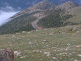
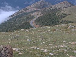
Trail Ridge Road is the name for a stretch of U.S. Highway 34 and is the highest continuous highway in the United States
. Also known as Trail Ridge Road/Beaver Meadow National Scenic Byway, it traverses Rocky Mountain National Park
from Estes Park, Colorado
in the east to Grand Lake, Colorado
in the west. It crosses the Continental Divide
at Milner Pass
(elev. 10,758 ft/3,279 m) and reaches a maximum elevation of 12,183 ft (3,713 m), near Fall River Pass
(elev. 11,796 ft/3,595 m). Near the highest point on the road is another pass, Iceberg Pass (elev. 11,827 ft/3,604 m).
Trail Ridge Road is closed during the winter, and often remains closed until late spring or early summer depending on the snowpack.It requires access to Rocky Mountain National Park even for local residents.
 From Kawuneeche Visitor Center at the park's Grand Lake Entrance, Trail Ridge Road follows the North Fork of the Colorado River north through the Kawuneeche Valley. There are several trailheads along this section of the road, notably the Colorado River Trailhead, which is the western terminus of the road segment closed during the winter.
After the Colorado River Trailhead, the road goes through a series of switchbacks
as it gains in elevation and turns to the east. The Farview Curve overlook provides an excellent view of the Kawuneeche Valley and the Never Summer Mountains
. Milner Pass carries the road over the Continental Divide and the route rounds Medicine Bow Curve before coming to a junction with Fall River Road at Fall River Pass near the popular Alpine Visitor Center
.
From the visitor center, Trail Ridge Road continues to the east and reaches its highest elevation of 12,183 feet (3,713 m) between the Gore Range
and Lava Cliffs overlooks. Iceberg Pass, marked by pullouts on both sides of the road, is crossed between Lava Cliffs and the Rock Cut overlook.
Trail Ridge Road descends toward the east as it passes the Rock Cut overlook and the popular overlooks of Forest Canyon and Rainbow Curve. Many Parks Curve marks the eastern terminus of the road segment closed during the winter. Continuing toward the park's eastern boundary, Hidden Valley is a popular winter recreation area with a warming shelter and heated rest rooms.
The road's eastern end is at Deer Ridge Junction where US 36 and US 34 meet in Estes Park. West of the junction, US 36 provides access to Horseshoe Park and the old Fall River Road.
was the first road into the park's high country. It opened in 1921 and quickly proved inadequate for motor travel as a single-track road with steep grades (up to 16%), tight curves and a short annual season due to snowpack. Construction began in 1929 and was complete to Fall River Pass by July 1932, with a maximum grade of 7%. The road was complete through the Kawuneeche Valley to Grand Lake
in 1938. The route followed what was known to local Arapaho
Indians as the Dog Trail. Internal opposition to the construction of the a road through the park's alpine tundra
was overruled by National Park Service
director Horace Albright, who wished to encourage park visitation. The road was designed to intrude as little as possible into the landscape, in accordance with Park Service design principles.
Hidden Valley (or Ski Estes Park) was a local ski area attraction from 1955 - 1991, off of Trail Ridge Road, now in defunct status.
United States
The United States of America is a federal constitutional republic comprising fifty states and a federal district...
. Also known as Trail Ridge Road/Beaver Meadow National Scenic Byway, it traverses Rocky Mountain National Park
Rocky Mountain National Park
Rocky Mountain National Park is a national park located in the north-central region of the U.S. state of Colorado.It features majestic mountain views, a variety of wildlife, varied climates and environments—from wooded forests to mountain tundra—and easy access to back-country trails...
from Estes Park, Colorado
Estes Park, Colorado
Estes Park is a town in Larimer County, Colorado, United States. A popular summer resort and the location of the headquarters for Rocky Mountain National Park, Estes Park lies along the Big Thompson River. Estes Park had a population of 5,858 at the 2010 census...
in the east to Grand Lake, Colorado
Grand Lake, Colorado
The Town of Grand Lake is a Statutory Town located in Grand County, Colorado, United States. The population was 447 at the 2000 census....
in the west. It crosses the Continental Divide
Continental Divide
The Continental Divide of the Americas, or merely the Continental Gulf of Division or Great Divide, is the name given to the principal, and largely mountainous, hydrological divide of the Americas that separates the watersheds that drain into the Pacific Ocean from those river systems that drain...
at Milner Pass
Milner Pass
Milner Pass, elevation is a mountain pass in the Rocky Mountains of northern Colorado in the United States. It is located on the continental divide in the Front Range, within Rocky Mountain National Park, along the boundary between Larimer and Grand counties. The pass provides the passage over the...
(elev. 10,758 ft/3,279 m) and reaches a maximum elevation of 12,183 ft (3,713 m), near Fall River Pass
Fall River Pass
-Fall River Pass:Fall River Pass is a mountain pass in the Rocky Mountains of northern Colorado in the United States. It is located on the in the Front Range, within Rocky Mountain National Park. The pass is traversed by U.S. Highway 34 on Trail Ridge Road between Estes Park and Granby...
(elev. 11,796 ft/3,595 m). Near the highest point on the road is another pass, Iceberg Pass (elev. 11,827 ft/3,604 m).
Trail Ridge Road is closed during the winter, and often remains closed until late spring or early summer depending on the snowpack.It requires access to Rocky Mountain National Park even for local residents.
Route description
After the Colorado River Trailhead, the road goes through a series of switchbacks
Hairpin turn
A hairpin turn , named for its resemblance to a hairpin/bobby pin, is a bend in a road with a very acute inner angle, making it necessary for an oncoming vehicle to turn almost 180° to continue on the road. Such turns in ramps and trails may be called switchbacks in American English, by analogy...
as it gains in elevation and turns to the east. The Farview Curve overlook provides an excellent view of the Kawuneeche Valley and the Never Summer Mountains
Never Summer Mountains
The Never Summer Mountains are a mountain range in the Rocky Mountains in north central Colorado in the United States. The range is located along the northwest border of Rocky Mountain National Park, forming the continental divide between the headwaters of the Colorado River in Rocky Mountain...
. Milner Pass carries the road over the Continental Divide and the route rounds Medicine Bow Curve before coming to a junction with Fall River Road at Fall River Pass near the popular Alpine Visitor Center
Alpine Visitor Center
Rocky Mountain National Park's Alpine Visitor Center is located at 11,796 feet above sea level at Fall River Pass, about two miles north of the highest point on Trail Ridge Road in the U.S. state of Colorado. The Alpine Visitor's Center includes restrooms, a restaurant and an information and gift...
.
From the visitor center, Trail Ridge Road continues to the east and reaches its highest elevation of 12,183 feet (3,713 m) between the Gore Range
Gore Range
The Gore Range is a mountain range in the Rocky Mountains of north central Colorado in the United States. The range runs for approximately 60 miles northwest-to-southeast, through western Grand and Summit counties, and eastern Routt and Eagle counties...
and Lava Cliffs overlooks. Iceberg Pass, marked by pullouts on both sides of the road, is crossed between Lava Cliffs and the Rock Cut overlook.
Trail Ridge Road descends toward the east as it passes the Rock Cut overlook and the popular overlooks of Forest Canyon and Rainbow Curve. Many Parks Curve marks the eastern terminus of the road segment closed during the winter. Continuing toward the park's eastern boundary, Hidden Valley is a popular winter recreation area with a warming shelter and heated rest rooms.
The road's eastern end is at Deer Ridge Junction where US 36 and US 34 meet in Estes Park. West of the junction, US 36 provides access to Horseshoe Park and the old Fall River Road.
History
Fall River RoadFall River Road
The Fall River Road in Rocky Mountain National Park was the first automobile road to penetrate the interior of the park. The road linked the east side of the park near Estes Park with Grand Lake on the west side. Work began in 1913 and was completed between 1918 and 1920. The narrow road was partly...
was the first road into the park's high country. It opened in 1921 and quickly proved inadequate for motor travel as a single-track road with steep grades (up to 16%), tight curves and a short annual season due to snowpack. Construction began in 1929 and was complete to Fall River Pass by July 1932, with a maximum grade of 7%. The road was complete through the Kawuneeche Valley to Grand Lake
Grand Lake, Colorado
The Town of Grand Lake is a Statutory Town located in Grand County, Colorado, United States. The population was 447 at the 2000 census....
in 1938. The route followed what was known to local Arapaho
Arapaho
The Arapaho are a tribe of Native Americans historically living on the eastern plains of Colorado and Wyoming. They were close allies of the Cheyenne tribe and loosely aligned with the Sioux. Arapaho is an Algonquian language closely related to Gros Ventre, whose people are seen as an early...
Indians as the Dog Trail. Internal opposition to the construction of the a road through the park's alpine tundra
Alpine tundra
Alpine tundra is a natural region that does not contain trees because it is at high altitude. Alpine tundra is distinguished from arctic tundra, because alpine soils are generally better drained than arctic soils...
was overruled by National Park Service
National Park Service
The National Park Service is the U.S. federal agency that manages all national parks, many national monuments, and other conservation and historical properties with various title designations...
director Horace Albright, who wished to encourage park visitation. The road was designed to intrude as little as possible into the landscape, in accordance with Park Service design principles.
Hidden Valley (or Ski Estes Park) was a local ski area attraction from 1955 - 1991, off of Trail Ridge Road, now in defunct status.
External links
- Trail Ridge Road/Beaver Meadow Road Overview on the National Scenic Byways website
- Trail Ridge Road on the Colorado Scenic Byways website
- Video from Top of Trail Ridge Road taken September, 2007.
- Rocky Mountain National Park Official Site