

Towrang, New South Wales
Encyclopedia
Towrang is a village in the Southern Tablelands
of New South Wales
, Australia
, in Goulburn Mulwaree Council
. It is approximately 13 km before Goulburn
on the Hume Highway
180 km south from Sydney
. At the 2006 census
, Towrang and the surrounding area had a population of 406.
The town was established in the 19th century, early in the European settlement of New South Wales. The area was once a large producer of fruit for the Sydney market. The railway station opened in 1869 and was one of the busiest in the state. The station closed in 1974 and has since been removed, after Goulburn outgrew Towrang and fruit production declined.
was located on the north side of the Hume Highway at Towrang Creek from around 1836 to 1842. The stockade was the major penal settlement in southern New South Wales and enforced harsh discipline. Around 250 convicts slept there on bare boards with a blanket each and 10 men to a cell. One of the floggers was later murdered.
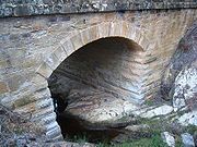
 There is a rest area on the south side where a well-preserved bridge (possibly designed by the designer of impressive early bridges in New South Wales, David Lennox
) and a culvert can be viewed.
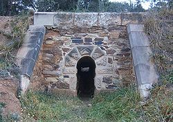
The stockade is on the north side of the Highway and used to be accessible by a stile, but this has been taken down to discourage people from stopping and using the daunting intersection with Towrang Road, especially for those turning right on to the Highway towards Goulburn. There are the remains of the powder magazine next to the Wollondilly River
, three graves on the north bank of Towrang Creek, and the remains of a weir on Towrang Creek built for the stockade. Aboriginal stone tools have also been found on the banks of Towrang Creek, indicating that this was a route well-travelled long before Hamilton Hume
came this way in 1818.
The Hume highway in this area has been recently upgraded from September 2007 - To improve safety at and in-between the 'seagull intersections' with Towrang and Carrick Roads under AusLink
http://www.albyschultz.com.au/news/default.asp?action=article&ID=657.
Southern Tablelands
The Southern Tablelands is a geographic area of the State of New South Wales, Australia. This area is located west of the Great Dividing Range.The area is characterised by flat country which has generally been extensively cleared and used for grazing purposes...
of New South Wales
New South Wales
New South Wales is a state of :Australia, located in the east of the country. It is bordered by Queensland, Victoria and South Australia to the north, south and west respectively. To the east, the state is bordered by the Tasman Sea, which forms part of the Pacific Ocean. New South Wales...
, Australia
Australia
Australia , officially the Commonwealth of Australia, is a country in the Southern Hemisphere comprising the mainland of the Australian continent, the island of Tasmania, and numerous smaller islands in the Indian and Pacific Oceans. It is the world's sixth-largest country by total area...
, in Goulburn Mulwaree Council
Goulburn Mulwaree Council
Goulburn Mulwaree Council is a Local Government Area of New South Wales, Australia. The council was formed as the Greater Argyle Council in 2004 as an amalgamation of Goulburn City and parts of the former Mulwaree Shire. It was renamed in 2005 following objections from the community...
. It is approximately 13 km before Goulburn
Goulburn, New South Wales
Goulburn is a provincial city in the Southern Tablelands of New South Wales, Australia in Goulburn Mulwaree Council Local Government Area. It is located south-west of Sydney on the Hume Highway and above sea-level. On Census night 2006, Goulburn had a population of 20,127 people...
on the Hume Highway
Hume Highway
The Hume Highway/Hume Freeway is one of Australia's major inter-city highways, running for 880 km between Sydney and Melbourne. It is part of the Auslink National Network and is a vital link for road freight to transport goods to and from the two cities as well as serving Albury-Wodonga and...
180 km south from Sydney
Sydney
Sydney is the most populous city in Australia and the state capital of New South Wales. Sydney is located on Australia's south-east coast of the Tasman Sea. As of June 2010, the greater metropolitan area had an approximate population of 4.6 million people...
. At the 2006 census
Census in Australia
The Australian census is administered once every five years by the Australian Bureau of Statistics. The most recent census was conducted on 9 August 2011; the next will be conducted in 2016. Prior to the introduction of regular censuses in 1961, they had also been run in 1901, 1911, 1921, 1933,...
, Towrang and the surrounding area had a population of 406.
The town was established in the 19th century, early in the European settlement of New South Wales. The area was once a large producer of fruit for the Sydney market. The railway station opened in 1869 and was one of the busiest in the state. The station closed in 1974 and has since been removed, after Goulburn outgrew Towrang and fruit production declined.
History
A major stockade for chain-bound convicts and others involved in the construction of the Great South RoadHume Highway
The Hume Highway/Hume Freeway is one of Australia's major inter-city highways, running for 880 km between Sydney and Melbourne. It is part of the Auslink National Network and is a vital link for road freight to transport goods to and from the two cities as well as serving Albury-Wodonga and...
was located on the north side of the Hume Highway at Towrang Creek from around 1836 to 1842. The stockade was the major penal settlement in southern New South Wales and enforced harsh discipline. Around 250 convicts slept there on bare boards with a blanket each and 10 men to a cell. One of the floggers was later murdered.
David Lennox
David Lennox was a Scottish-Australian bridge-builder and master stonemason born in Ayr, Scotland.-Personal details:...
) and a culvert can be viewed.
The stockade is on the north side of the Highway and used to be accessible by a stile, but this has been taken down to discourage people from stopping and using the daunting intersection with Towrang Road, especially for those turning right on to the Highway towards Goulburn. There are the remains of the powder magazine next to the Wollondilly River
Wollondilly River
The Wollondilly River is a perennial river in New South Wales, Australia. It was originally a tributary of the Warragamba River, and hence of the Nepean and Hawkesbury Rivers...
, three graves on the north bank of Towrang Creek, and the remains of a weir on Towrang Creek built for the stockade. Aboriginal stone tools have also been found on the banks of Towrang Creek, indicating that this was a route well-travelled long before Hamilton Hume
Hamilton Hume
Hamilton Hume was the first Australian born explorer. Along with Hovell in 1824, Hume was part of an expedition that first took an overland route from Sydney to Port Phillip near the site of present day Melbourne...
came this way in 1818.
The Hume highway in this area has been recently upgraded from September 2007 - To improve safety at and in-between the 'seagull intersections' with Towrang and Carrick Roads under AusLink
AusLink
AusLink was an Australian Government land transport funding program, established in June 2004 and administered by the Department of Transport and Regional Services. In 2009 it was replaced with the Nation Building Program under the Nation Building Program Act 2009...
http://www.albyschultz.com.au/news/default.asp?action=article&ID=657.