
Town of Narrogin
Encyclopedia
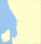
The Town of Narrogin is a Local Government Area
of Western Australia
for the town of Narrogin
in the Wheatbelt region of Western Australia, 192 kilometres (119 mi) south-east of the capital, Perth
along Great Southern Highway
. The Shire has a population of 4,238 (ABS 2006).
Local Government Areas of Western Australia
The Australian state of Western Australia is divided into 141 local government areas...
of Western Australia
Western Australia
Western Australia is a state of Australia, occupying the entire western third of the Australian continent. It is bounded by the Indian Ocean to the north and west, the Great Australian Bight and Indian Ocean to the south, the Northern Territory to the north-east and South Australia to the south-east...
for the town of Narrogin
Narrogin, Western Australia
Narrogin is a large town in the Wheatbelt region of Western Australia, southeast of Perth on the Great Southern Highway between Pingelly and Wagin...
in the Wheatbelt region of Western Australia, 192 kilometres (119 mi) south-east of the capital, Perth
Perth, Western Australia
Perth is the capital and largest city of the Australian state of Western Australia and the fourth most populous city in Australia. The Perth metropolitan area has an estimated population of almost 1,700,000....
along Great Southern Highway
Great Southern Highway
Great Southern Highway is a highway in the Southern Wheatbelt region of Western Australia, starting from Great Eastern Highway at The Lakes, 50 km from Perth, and ending at Albany Highway near Cranbrook. It is the primary thoroughfare for this part of Western Australia and runs parallel with the...
. The Shire has a population of 4,238 (ABS 2006).
| Pages associated with Narrogin, Western Australia Narrogin, Western Australia Narrogin is a large town in the Wheatbelt region of Western Australia, southeast of Perth on the Great Southern Highway between Pingelly and Wagin... |
|---|
|
History
On 13 April 1906, the Municipality of Narrogin came into being. On 1 July 1961, it became a Town under the Local Government Act 1960.Population
| Year | Population |
|---|---|
| 1911 | 923 |
| 1921 | 1,872 |
| 1933 | 2,466 |
| 1947 | 2,558 |
| 1954 | 3,768 |
| 1961 | 4,620 |
| 1966 | 4,861 |
| 1971 | 4,849 |
| 1976 | 4,805 |
| 1981 | 5,146 |
| 1986 | 5,043 |
| 1991 | 4,635 |
| 1996 | 4,477 |
| 2001 | 4,424 |
| 2006 | 4,238 |