

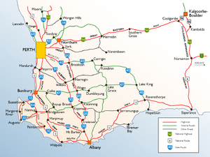
Great Southern Highway
Encyclopedia
Western Australia
Western Australia is a state of Australia, occupying the entire western third of the Australian continent. It is bounded by the Indian Ocean to the north and west, the Great Australian Bight and Indian Ocean to the south, the Northern Territory to the north-east and South Australia to the south-east...
, starting from Great Eastern Highway
Great Eastern Highway
The Great Eastern Highway is a major road between the Western Australian cities of Perth and Kalgoorlie. It is a key route for vehicles accessing the eastern wheatbelt and the eastern goldfields...
at The Lakes
The Lakes, Western Australia
The Lakes is a locality in Western Australia within the Shire of Mundaring. It is located east of the capital city of Perth at the junction of the Great Eastern Highway and the Great Southern Highway, and is the easternmost suburb within the Metropolitan Region Scheme...
, 50 km from Perth
Perth, Western Australia
Perth is the capital and largest city of the Australian state of Western Australia and the fourth most populous city in Australia. The Perth metropolitan area has an estimated population of almost 1,700,000....
, and ending at Albany Highway
Albany Highway
Albany Highway is a generally northwest-southeast highway in the south of Western Australia which links the state's capital Perth with its oldest settlement, Albany. The highway is approximately in length, is designated State Route 30 and separates Western Australia's Great Southern region from...
near Cranbrook
Cranbrook, Western Australia
Cranbrook is a small town in the Great Southern region of Western Australia between Katanning, Kojonup and Mount Barker, situated 320km south of Perth. It is billed as "The Gateway to the Stirlings", referring to the nearby Stirling Range National Park...
. It is the primary thoroughfare for this part of Western Australia and runs parallel with the Perth-Albany railway for its entire length. It is signed as State Route 120 from York to Cranbrook, and was first named in 1949, although was built well before that time.
Description
The highway initially travels east to the historic town of YorkYork, Western Australia
York is the oldest inland town in Western Australia, situated 97 km east of Perth in the Avon Valley near Northam, and is the seat of the Shire of York...
, before following the Avon Valley and the railway roughly southwards until Narrogin
Narrogin, Western Australia
Narrogin is a large town in the Wheatbelt region of Western Australia, southeast of Perth on the Great Southern Highway between Pingelly and Wagin...
. The highway then runs parallel with Albany Highway
Albany Highway
Albany Highway is a generally northwest-southeast highway in the south of Western Australia which links the state's capital Perth with its oldest settlement, Albany. The highway is approximately in length, is designated State Route 30 and separates Western Australia's Great Southern region from...
at a distance of about 30 km through Wagin
Wagin, Western Australia
Wagin is a town and shire in the Great Southern region of Western Australia, approximately 225 km south-east of Perth on the Great Southern Highway between Narrogin and Katanning. It is also on State Route 107. The main industries are wheat and sheep farming.-History:The name of the town is...
and Katanning
Katanning, Western Australia
Katanning is a town located 277 km south east of Perth, Western Australia on the Great Southern Highway. At the 2006 census, Katanning had a population of 3,808.-History:...
before curving to approach Albany Highway where it ends 4 km past Cranbrook
Cranbrook, Western Australia
Cranbrook is a small town in the Great Southern region of Western Australia between Katanning, Kojonup and Mount Barker, situated 320km south of Perth. It is billed as "The Gateway to the Stirlings", referring to the nearby Stirling Range National Park...
. Many of the towns along this highway have prominent grain silos, and Narrogin, Wagin and Katanning have remained important population centres sustained by agriculture and its supporting industries.
Towns
Towns on this highway include:- The LakesThe Lakes, Western AustraliaThe Lakes is a locality in Western Australia within the Shire of Mundaring. It is located east of the capital city of Perth at the junction of the Great Eastern Highway and the Great Southern Highway, and is the easternmost suburb within the Metropolitan Region Scheme...
- YorkYork, Western AustraliaYork is the oldest inland town in Western Australia, situated 97 km east of Perth in the Avon Valley near Northam, and is the seat of the Shire of York...
- BeverleyBeverley, Western AustraliaBeverley is a town located in the Wheatbelt region of Western Australia, south-east of the state capital, Perth, between York and Brookton on the Great Southern Highway...
- BrooktonBrookton, Western AustraliaBrookton is a town located in the Wheatbelt region of Western Australia, Australia, from the state capital, Perth via the Brookton Highway where it crosses the Great Southern Highway. The town is also located on the Great Southern railway line. It is located within, and is the seat of government...
- PingellyPingelly, Western AustraliaPingelly is a town and shire located in the Wheatbelt region of Western Australia, from Perth via the Brookton Highway and Great Southern Highway. The town is also located on the Great Southern railway line...
- PopanyinningPopanyinning, Western AustraliaPopanyinning is a small town located in the Wheatbelt region of Western Australia, along Great Southern Highway between Pingelly and Narrogin. At the 2006 census, Popanyinning had a population of 87.-History:...
- CuballingCuballing, Western AustraliaCuballing is a town located in the Wheatbelt region of Western Australia, on Great Southern Highway, between Pingelly and Narrogin. At the 2006 census, Cuballing had a population of 335.-History:...
- NarroginNarrogin, Western AustraliaNarrogin is a large town in the Wheatbelt region of Western Australia, southeast of Perth on the Great Southern Highway between Pingelly and Wagin...
- HighburyHighbury, Western AustraliaHighbury is a small town in the Wheatbelt region of Western Australia, located along the Great Southern Highway between Narrogin and Wagin. At the 2006 census, Highbury had a population of 493.-History:...
- WaginWagin, Western AustraliaWagin is a town and shire in the Great Southern region of Western Australia, approximately 225 km south-east of Perth on the Great Southern Highway between Narrogin and Katanning. It is also on State Route 107. The main industries are wheat and sheep farming.-History:The name of the town is...
- WoodanillingWoodanilling, Western AustraliaWoodanilling is a small town in the Great Southern region of Western Australia, 254 km south of Perth on the Great Southern Highway, 24 km from Katanning and 30 km from Wagin....
- KatanningKatanning, Western AustraliaKatanning is a town located 277 km south east of Perth, Western Australia on the Great Southern Highway. At the 2006 census, Katanning had a population of 3,808.-History:...
- BroomehillBroomehill, Western AustraliaBroomehill is a town located along the Great Southern Highway between Katanning and Albany, in the Great Southern region of Western Australia.- History :...
- TambellupTambellup, Western AustraliaThe townsite of Tambellup is located in Western Australia's Great Southern Agricultural region, 317 km south-east of Perth on the Great Southern Highway where it crosses the Gordon River...
- CranbrookCranbrook, Western AustraliaCranbrook is a small town in the Great Southern region of Western Australia between Katanning, Kojonup and Mount Barker, situated 320km south of Perth. It is billed as "The Gateway to the Stirlings", referring to the nearby Stirling Range National Park...