

Torreys Peak
Encyclopedia
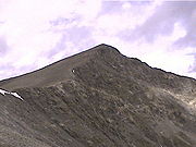
Torreys Peak is a mountain
in the Front Range
region of the Rocky Mountains
in Colorado
. It is one of 54 fourteener
s in Colorado. Its nearest major city is Denver
. The first man to ascend Torreys Peak, botanist Charles C. Parry, named the peak for his botanist colleague John Torrey. Torrey actually did not see the peak until 1872, 11 years later. It is nearly always mentioned in conjunction with nearby Grays Peak
. Torreys Peak is located along the Continental Divide
, as well as the division between Clear Creek County and Summit County
.
There are three main trails used to reach the summit. The first is actually a continuation of Grays Peak Trail
to the summit of Grays Peak, which starts in Stevens Gulch. See the Grays Peak
article for more information on accessing that trail.
A popular and challenging variation of this trail follows class-3 Kelso Ridge. This route splits from the Grays Peak trail 2 miles (3.2 km) from the trailhead, climbs to the 12400 feet (3,779.5 m) saddle between Torreys and 13164 feet (4,012.4 m) Kelso Mountain, then follows the rugged ridge about 1 miles (1.6 km) to the summit.
The third trail starts at Loveland Pass
about 4.5 miles (7.2 km) to the northwest. To reach Loveland Pass, follow I-70
west from Denver 55 miles (88.5 km) to where US Route 6 breaks off and heads south. Follow the meandering Route 6 approximately seven miles to the trailhead at Loveland Pass, at an elevation of 11990 feet (3,654.6 m). The steepest part of the trail actually begins right away with a half mile climb of 1000 feet (304.8 m). The trail follows the Continental Divide gently taking the climber down into three saddles and up two more peaks, including Grizzly Peak
(13,427 feet). The final saddle rests at approximately 12,600. From this saddle, it is a mile-long ascent of 1800 feet (548.6 m) to the final summit.
Once at the summit, many opt to continue on to Grays Peak, 0.75 miles (1.2 km) away. The trail from Torreys Peak to Grays Peak dips down to a 13707 feet (4,177.9 m) saddle and then climbs back up to 14270 feet (4,349.5 m).
Mountain
Image:Himalaya_annotated.jpg|thumb|right|The Himalayan mountain range with Mount Everestrect 58 14 160 49 Chomo Lonzorect 200 28 335 52 Makalurect 378 24 566 45 Mount Everestrect 188 581 920 656 Tibetan Plateaurect 250 406 340 427 Rong River...
in the Front Range
Front Range
The Front Range is a mountain range of the Southern Rocky Mountains of North America located in the north-central portion of the U.S. State of Colorado and southeastern portion of the U.S. State of Wyoming. It is the first mountain range encountered moving west along the 40th parallel north across...
region of the Rocky Mountains
Rocky Mountains
The Rocky Mountains are a major mountain range in western North America. The Rocky Mountains stretch more than from the northernmost part of British Columbia, in western Canada, to New Mexico, in the southwestern United States...
in Colorado
Colorado
Colorado is a U.S. state that encompasses much of the Rocky Mountains as well as the northeastern portion of the Colorado Plateau and the western edge of the Great Plains...
. It is one of 54 fourteener
Fourteener
In mountaineering terminology in the United States, a fourteener is a mountain that exceeds 14,000 feet above mean sea level. There are 547 fourteeners in the world. The importance of fourteeners is greatest in Colorado, which has the majority of such peaks in North America...
s in Colorado. Its nearest major city is Denver
Denver, Colorado
The City and County of Denver is the capital and the most populous city of the U.S. state of Colorado. Denver is a consolidated city-county, located in the South Platte River Valley on the western edge of the High Plains just east of the Front Range of the Rocky Mountains...
. The first man to ascend Torreys Peak, botanist Charles C. Parry, named the peak for his botanist colleague John Torrey. Torrey actually did not see the peak until 1872, 11 years later. It is nearly always mentioned in conjunction with nearby Grays Peak
Grays Peak
Grays Peak is the highest mountain in the Front Range of the Southern Rocky Mountains in the U.S. State of Colorado. It is one of 54 fourteeners in Colorado. Its nearest major city is Denver. The first man to ascend Grays Peak, botanist Charles C. Parry, named the peak for his botanist...
. Torreys Peak is located along the Continental Divide
Continental Divide
The Continental Divide of the Americas, or merely the Continental Gulf of Division or Great Divide, is the name given to the principal, and largely mountainous, hydrological divide of the Americas that separates the watersheds that drain into the Pacific Ocean from those river systems that drain...
, as well as the division between Clear Creek County and Summit County
Summit County, Colorado
Summit County is the 19th most populous of the 64 counties of the state of Colorado of the United States. The county population was 23,538 at U.S. Census 2000. The county seat is Breckenridge...
.
There are three main trails used to reach the summit. The first is actually a continuation of Grays Peak Trail
Grays Peak Trail
Grays Peak National Recreation Trail or Grays Peak Trail lies along the Continental Divide of the Americas, part of the Rocky Mountains in the US state of Colorado. It is located in the White River National Forest, Summit County. Grays Peak Trail is south of Interstate 70, east of Keystone...
to the summit of Grays Peak, which starts in Stevens Gulch. See the Grays Peak
Grays Peak
Grays Peak is the highest mountain in the Front Range of the Southern Rocky Mountains in the U.S. State of Colorado. It is one of 54 fourteeners in Colorado. Its nearest major city is Denver. The first man to ascend Grays Peak, botanist Charles C. Parry, named the peak for his botanist...
article for more information on accessing that trail.
A popular and challenging variation of this trail follows class-3 Kelso Ridge. This route splits from the Grays Peak trail 2 miles (3.2 km) from the trailhead, climbs to the 12400 feet (3,779.5 m) saddle between Torreys and 13164 feet (4,012.4 m) Kelso Mountain, then follows the rugged ridge about 1 miles (1.6 km) to the summit.
The third trail starts at Loveland Pass
Loveland Pass
Loveland Pass, elevation 11,990 ft. above sea level, is a high mountain pass in the Rocky Mountains of north-central Colorado, U.S.A.....
about 4.5 miles (7.2 km) to the northwest. To reach Loveland Pass, follow I-70
Interstate 70
Interstate 70 is an Interstate Highway in the United States that runs from Interstate 15 near Cove Fort, Utah, to a Park and Ride near Baltimore, Maryland. It was the first Interstate Highway project in the United States. I-70 approximately traces the path of U.S. Route 40 east of the Rocky...
west from Denver 55 miles (88.5 km) to where US Route 6 breaks off and heads south. Follow the meandering Route 6 approximately seven miles to the trailhead at Loveland Pass, at an elevation of 11990 feet (3,654.6 m). The steepest part of the trail actually begins right away with a half mile climb of 1000 feet (304.8 m). The trail follows the Continental Divide gently taking the climber down into three saddles and up two more peaks, including Grizzly Peak
Grizzly Peak (Colorado)
Grizzly Peak is a mountain in Colorado, the highest thirteener in the state. The mountain is composed of andesite lava flows and breccias of Oligocene age. It is located in the Sawatch Range on the Continental Divide, on the border between Pitkin County and Chaffee County...
(13,427 feet). The final saddle rests at approximately 12,600. From this saddle, it is a mile-long ascent of 1800 feet (548.6 m) to the final summit.
Once at the summit, many opt to continue on to Grays Peak, 0.75 miles (1.2 km) away. The trail from Torreys Peak to Grays Peak dips down to a 13707 feet (4,177.9 m) saddle and then climbs back up to 14270 feet (4,349.5 m).
See also
- List of Colorado fourteeners
- Mountain peaks of ColoradoMountain peaks of ColoradoThis article comprises three sortable tables of the major mountain peaks of the U.S. State of Colorado.Topographic elevation is the vertical distance above the reference geoid, a precise mathematical model of the Earth's sea level as an equipotential gravitational surface...
- Mountain ranges of ColoradoMountain ranges of ColoradoThe following table lists the major mountain ranges of the U.S. State of Colorado.-Mountain Ranges:-See also:*4000 meter peaks of Colorado*Colorado mountain passes*Geography of Colorado*Lists of mountains*Mountain peaks of Colorado...