

Timeline of town creation in Central New York
Encyclopedia
The towns and cities of Central New York were created by the US state of New York
as municipalities in order to give residents more direct say over local government. Central New York
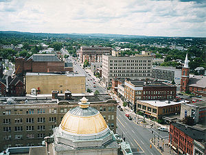
(consisting of the Syracuse
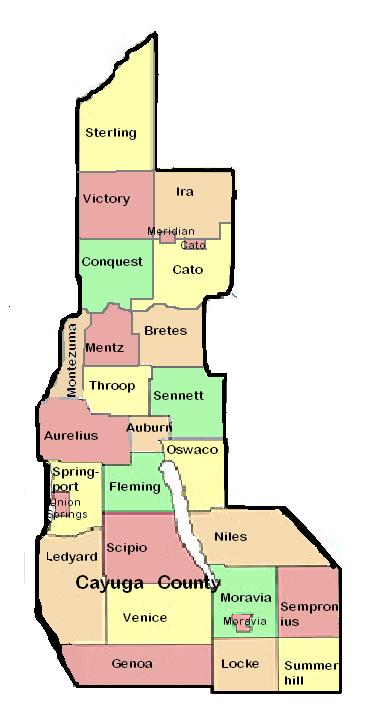
Consolidated Metropolitan Statistical Area and the Utica-Rome Metropolitan Statistical Area) is a six county area–Cayuga County
, Herkimer County
, Madison County
, Oneida County
, Onondaga County
, and Oswego County
. The entire area was nominally under the jurisdiction of Albany County
from 1686 until the Royal Proclamation of 1763
but truly under the Iroquois Confederacy until 1777 then nominally Tryon County
(renamed Montgomery County
in 1784) from 1781 and effectively in 1784, and Herkimer County from 1791. In 1794 the western section of Herkimer County was split off as Onondaga County, and then in 1798 the northwestern section of Herkimer was removed as Oneida County and the southwestern section as Chenango County
. Cayuga County was removed from Onondaga in 1799, Madison County from Chenango in 1806, and Oswego from Onondaga and Oneida in 1816. The current towns of Herkimer, Oneida, and Madison counties are descended from the original districts and towns of Montgomery County; whereas the towns of Onondaga and Cayuga counties are descended from the towns erected by the state when Onondaga County was formed from the Military Tract in western Herkimer County which had previously been divided into townships for the purpose of surveying of lands to be sold to veteran
s of the US Revolutionary War.
New York experimented with different types of municipalities before settling upon the current format of towns and cities occupying all the land in a county, and all previous forms were transformed into towns (or divided into multiple towns) in 1788 when all of the state of New York was divided into towns. Some early forms of government in earlier years included land patents with some municipal rights, districts, precincts, and boroughs. Though originally intended to be mere “…involuntary subdivisions of the state, constituted for the purpose of the more convenient exercise of governmental functions by the state for the benefit of all its citizens” as defined by the courts in 1916 (Short v. Town of Orange
), towns gained home rule
powers from the state in 1964, at which time towns became "a municipal corporation comprising the inhabitants within its boundaries, and formed with the purpose of exercising such powers and discharging such duties of local government and administration of public affairs as have been, or, maybe [sic
] conferred or imposed upon it by law.”
The following is a timeline showing the creation of the current towns from their predecessors stretching back to the earliest municipal entity over the area. The timelines only represent from which town(s) a particular town was created from and does not represent annexations of territory to and from towns that already existed. All municipalities are towns unless otherwise noted as patent, township, borough, district, or city.

New York
New York is a state in the Northeastern region of the United States. It is the nation's third most populous state. New York is bordered by New Jersey and Pennsylvania to the south, and by Connecticut, Massachusetts and Vermont to the east...
as municipalities in order to give residents more direct say over local government. Central New York
Central New York
Central New York is a term used to broadly describe the central region of New York State, roughly including the following counties and cities:...
(consisting of the Syracuse
Syracuse metropolitan area
The Syracuse Metropolitan Statistical Area, as defined by the United States Census Bureau, is an area consisting of three counties in central New York, anchored by the city of Syracuse...
Consolidated Metropolitan Statistical Area and the Utica-Rome Metropolitan Statistical Area) is a six county area–Cayuga County
Cayuga County, New York
Cayuga County is a county located in the U.S. state of New York. It was named for one of the tribes of Indians in the Iroquois Confederation. Its county seat is Auburn.- History :...
, Herkimer County
Herkimer County, New York
Herkimer County is a county located in the U.S. state of New York. It was created in 1791 north of the Mohawk River out of part of Montgomery County. As of the 2010 census, the population was 64,519. It is named after General Nicholas Herkimer, who died from battle wounds in 1777 after taking part...
, Madison County
Madison County, New York
Madison County is a county located in the U.S. state of New York. As of the 2010 census, the population was 73,442. It is named after James Madison, fourth President of the United States of America...
, Oneida County
Oneida County, New York
Oneida County is a county located in the U.S. state of New York. As of the 2010 census, the population was 234,878. The county seat is Utica. The name is in honor of the Oneida, an Iroquoian tribe that formerly occupied the region....
, Onondaga County
Onondaga County, New York
Onondaga County is a county located in the U.S. state of New York. As of the 2010 census, the population was 467,026. The county seat is Syracuse.Onondaga County is part of the Syracuse, NY Metropolitan Statistical Area....
, and Oswego County
Oswego County, New York
Oswego County is a county located in the U.S. state of New York. As of the 2010 Census, the estimated population was 122,109. The City of Oswego and the Village of Pulaski serve as the dual county seats in a two shire system of government...
. The entire area was nominally under the jurisdiction of Albany County
Albany County, New York
Albany County is a county located in the U.S. state of New York, and is part of the Albany-Schenectady-Troy Metropolitan Statistical Area. The name is from the title of the Duke of York and Albany, who became James II of England . As of the 2010 census, the population was 304,204...
from 1686 until the Royal Proclamation of 1763
Royal Proclamation of 1763
The Royal Proclamation of 1763 was issued October 7, 1763, by King George III following Great Britain's acquisition of French territory in North America after the end of the French and Indian War/Seven Years' War...
but truly under the Iroquois Confederacy until 1777 then nominally Tryon County
Tryon County, New York
Tryon County, New York was a county in the colonial Province of New York in the British American colonies. It was created from Albany County on March 24, 1772. It was named for William Tryon, the last provincial governor of New York. Its boundaries extended far further than any current county...
(renamed Montgomery County
Montgomery County, New York
As of the census of 2000, there were 49,708 people, 20,038 households, and 13,104 families residing in the county. The population density was 123 people per square mile . There were 22,522 housing units at an average density of 56 per square mile...
in 1784) from 1781 and effectively in 1784, and Herkimer County from 1791. In 1794 the western section of Herkimer County was split off as Onondaga County, and then in 1798 the northwestern section of Herkimer was removed as Oneida County and the southwestern section as Chenango County
Chenango County, New York
Chenango County is a county located in the U.S. state of New York. As of the 2010 census, the population was 50,477. The county's name originates from an Oneida word meaning "large bull-thistle." Its county seat is Norwich.-History:...
. Cayuga County was removed from Onondaga in 1799, Madison County from Chenango in 1806, and Oswego from Onondaga and Oneida in 1816. The current towns of Herkimer, Oneida, and Madison counties are descended from the original districts and towns of Montgomery County; whereas the towns of Onondaga and Cayuga counties are descended from the towns erected by the state when Onondaga County was formed from the Military Tract in western Herkimer County which had previously been divided into townships for the purpose of surveying of lands to be sold to veteran
Veteran
A veteran is a person who has had long service or experience in a particular occupation or field; " A veteran of ..."...
s of the US Revolutionary War.
New York experimented with different types of municipalities before settling upon the current format of towns and cities occupying all the land in a county, and all previous forms were transformed into towns (or divided into multiple towns) in 1788 when all of the state of New York was divided into towns. Some early forms of government in earlier years included land patents with some municipal rights, districts, precincts, and boroughs. Though originally intended to be mere “…involuntary subdivisions of the state, constituted for the purpose of the more convenient exercise of governmental functions by the state for the benefit of all its citizens” as defined by the courts in 1916 (Short v. Town of Orange
Orange, New York
----Orange is a town in Schuyler County, New York, United States. The population was 1,752 at the 2000 census.The Town of Orange is in the southwest part of the county and is east of Bath, New York.- History :...
), towns gained home rule
Home rule
Home rule is the power of a constituent part of a state to exercise such of the state's powers of governance within its own administrative area that have been devolved to it by the central government....
powers from the state in 1964, at which time towns became "a municipal corporation comprising the inhabitants within its boundaries, and formed with the purpose of exercising such powers and discharging such duties of local government and administration of public affairs as have been, or, maybe [sic
Sic
Sic—generally inside square brackets, [sic], and occasionally parentheses, —when added just after a quote or reprinted text, indicates the passage appears exactly as in the original source...
] conferred or imposed upon it by law.”
The following is a timeline showing the creation of the current towns from their predecessors stretching back to the earliest municipal entity over the area. The timelines only represent from which town(s) a particular town was created from and does not represent annexations of territory to and from towns that already existed. All municipalities are towns unless otherwise noted as patent, township, borough, district, or city.
Herkimer County
Oneida County
Oswego County
Madison County
Onondaga County
Cayuga County
See also
- Administrative divisions of New YorkAdministrative divisions of New YorkThe administrative divisions of New York are the various units of government that provide local government services in the state of New York. The state has four types of multi-purpose municipal corporation that provide most local government services, namely: counties, cities, towns, and villages...
- List of cities in New York
- List of towns in New York
- List of villages in New York
- Timeline of town creation in Downstate New YorkTimeline of town creation in Downstate New YorkThe towns and cities of Downstate New York were created by the US state of New York as municipalities in order to give residents more direct say over local government...
- Timeline of town creation in New York's Capital DistrictTimeline of town creation in New York's Capital DistrictThe towns and cities of New York's Capital District were created by the US state of New York as municipalities in order to give residents more direct say over local government. The Capital District is an 11 county area, which consists of the counties of Albany, Schenectady, Rensselaer, Saratoga,...
- Timeline of town creation in the Hudson ValleyTimeline of town creation in the Hudson ValleyThe towns and cities of the Hudson Valley were created by the US state of New York as municipalities, in order to perform the services of local government. In 1683, prior to the creation of modern towns, the Province of New York was divided into twelve counties for administrative purposes by the...