

Thurnham Castle
Encyclopedia
Thurnham, Kent
Thurnham is a village and civil parish which lies at the foot of the North Downs north east of Maidstone in the Borough of Maidstone and ceremonial county of Kent in England. It has a population of 1,085....
which is 3 miles north-east of Maidstone
Maidstone
Maidstone is the county town of Kent, England, south-east of London. The River Medway runs through the centre of the town linking Maidstone to Rochester and the Thames Estuary. Historically, the river was a source and route for much of the town's trade. Maidstone was the centre of the agricultural...
, Kent
Kent
Kent is a county in southeast England, and is one of the home counties. It borders East Sussex, Surrey and Greater London and has a defined boundary with Essex in the middle of the Thames Estuary. The ceremonial county boundaries of Kent include the shire county of Kent and the unitary borough of...
.
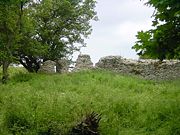
It is a 12th century flint-built
Flint
Flint is a hard, sedimentary cryptocrystalline form of the mineral quartz, categorized as a variety of chert. It occurs chiefly as nodules and masses in sedimentary rocks, such as chalks and limestones. Inside the nodule, flint is usually dark grey, black, green, white, or brown in colour, and...
castle constructed by Robert de Thurnham in the reign of Henry II
Henry II of England
Henry II ruled as King of England , Count of Anjou, Count of Maine, Duke of Normandy, Duke of Aquitaine, Duke of Gascony, Count of Nantes, Lord of Ireland and, at various times, controlled parts of Wales, Scotland and western France. Henry, the great-grandson of William the Conqueror, was the...
on a hill on the edge of the North Downs
North Downs
The North Downs are a ridge of chalk hills in south east England that stretch from Farnham in Surrey to the White Cliffs of Dover in Kent. The North Downs lie within two Areas of Outstanding Natural Beauty , the Surrey Hills and the Kent Downs...
. One side of the bailey wall still stands 10 foot high and originally it enclosed an area of about a quarter of an acre. There is no visible stonework on the large motte.
The site has been acquired by Kent County Council and included in the White Horse Millennium Wood and Country Park Project. Much of the site has been cleared of undergrowth and public access has been provided.