

The Wiggle
Encyclopedia
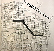
The Wiggle is a one-mile, zig-zagging bicycle route from Market Street
to Golden Gate Park
in San Francisco, California
, that minimizes hilly inclines for bicycle riders. Rising 120 feet (36.6 m), The Wiggle inclines average 3% and never exceed 6%. The path generally follows the historical route of the long since paved-over Sans Souci Valley watercourse, winding through the Lower Haight neighborhood toward the Panhandle
section of Golden Gate Park.
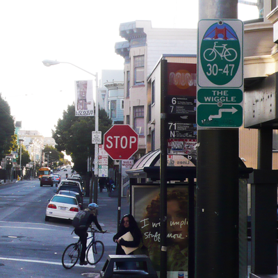 The lower end of the route begins at either end of the Duboce Bikeway in the block of Duboce Avenue just west of Market Street. The elevation is approximately 100 feet (30.5 m) above sea level. It then moves in a zig-zag toward the northwest along Duboce Avenue, Steiner, Waller, Pierce, Haight, Scott, and Fell Streets to the Panhandle Bikeway, 215 feet (65.5 m) above sea level. After climbing 50 more feet, the peak of The Wiggle is reached near Stanyan Street at the peninsular drainage divide, i.e., the dividing point between surface water flowing to the San Francisco Bay
on the east side and flowing to the Pacific Ocean
on the west.
Bicyclists can travel The Wiggle between major eastern and central neighborhoods (such as Downtown, SoMa
, The Mission District, The Castro) and major western neighborhoods (including the Panhandle, The Haight, Golden Gate Park, and The Richmond and Sunset Districts).
 Below are five route-finding techniques for those who follow the Wiggle: Geography, Signage, Map, Directions and a Mnemonic trick.
Thus, starting northbound on Church at Market or westbound on Duboce at Market this pattern will avoid all steep areas and produce a route from Market Street to the bike path in the Panhandle of Golden Gate Park and the main routes through the Park itself. Similar "wiggles" can be found using this method for reading the geography in other hill areas, though this wiggle route is known most widely.
OR
you can use:
Da Small White Pigs Had Some Figs: Duboce, Steiner, Waller, Pierce, Haight, Scott, Fell. (West bound)
Fa Sho Hannah Played With Sand Dunes: Fell, Scott, Haight, Pierce, Waller, Steiner, Duboce. (East bound)
The adjacent hills on the southwest are of the Franciscan
chert
formation:
These hills are the northernmost manifestation of the San Miguel Hills (including Twin Peaks), which themselves comprise the northern tip of the Santa Cruz Mountains
.
Over thousands of years, the gentle valley bottom was formed through a process of gradual erosion of the soft, crumbly serpentine. This flat creek bed contained, until roads and other construction obliterated them, the intermittent stream of the creek itself and two ponds. as with all such flat valleys, the location of ponds tended to shift, but they were generally located at what is now Divisadero Street near Oak Street and at Market Street from Belcher Street to Reservoir Street—a little known public street which is currently the parking lot entry for the Safeway grocery store at 2020 Market Street. (The back of this store is located at the start of the Wiggle.) The reservoir referenced was the successor to the pond.
.
When the San Francisco Presidio and the Mission Dolores were founded in 1776, the trail became a horseback connector eventually called "the Old Spanish Trail." In the 19th century, the trail was the commute route of military personnel who lived in the Mission District and worked at the Presidio. In the 1860s, it finally was widened to become a toll road, passable by carriages, and going by the name "Divisadero" or "Devisadero" Street. In the 1870s, a grid of streets was imposed in its place, one retaining the old road's name, across a newly formed neighborhood with all the sandy hills and steep gullies filled or scraped flat.
Market Street (San Francisco)
Market Street is an important thoroughfare in San Francisco, California. It begins at The Embarcadero in front of the Ferry Building at the northeastern edge of the city and runs southwest through downtown, passing the Civic Center and the Castro District, to the intersection with Corbett Avenue in...
to Golden Gate Park
Golden Gate Park
Golden Gate Park, located in San Francisco, California, is a large urban park consisting of of public grounds. Configured as a rectangle, it is similar in shape but 20% larger than Central Park in New York, to which it is often compared. It is over three miles long east to west, and about half a...
in San Francisco, California
California
California is a state located on the West Coast of the United States. It is by far the most populous U.S. state, and the third-largest by land area...
, that minimizes hilly inclines for bicycle riders. Rising 120 feet (36.6 m), The Wiggle inclines average 3% and never exceed 6%. The path generally follows the historical route of the long since paved-over Sans Souci Valley watercourse, winding through the Lower Haight neighborhood toward the Panhandle
Panhandle (San Francisco)
The Panhandle is a park in San Francisco, California that forms a panhandle with Golden Gate Park. It is long and narrow, being three-quarters of a mile long and one block wide. Fell Street borders it to the north, Oak Street to the south, and Baker Street to the east. The Haight-Ashbury District...
section of Golden Gate Park.
San Francisco Bay
San Francisco Bay is a shallow, productive estuary through which water draining from approximately forty percent of California, flowing in the Sacramento and San Joaquin rivers from the Sierra Nevada mountains, enters the Pacific Ocean...
on the east side and flowing to the Pacific Ocean
Pacific Ocean
The Pacific Ocean is the largest of the Earth's oceanic divisions. It extends from the Arctic in the north to the Southern Ocean in the south, bounded by Asia and Australia in the west, and the Americas in the east.At 165.2 million square kilometres in area, this largest division of the World...
on the west.
Bicyclists can travel The Wiggle between major eastern and central neighborhoods (such as Downtown, SoMa
South of Market, San Francisco, California
South of Market is a neighborhood in San Francisco, California, United States.-Name and location:Its boundaries are Market Street to the northwest, San Francisco Bay to the northeast, Mission Creek to the southeast, and Division Street, 13th Street and U.S. Route 101 to the southwest...
, The Mission District, The Castro) and major western neighborhoods (including the Panhandle, The Haight, Golden Gate Park, and The Richmond and Sunset Districts).
The route
Geographic route-finding
Without memorizing streets, a simple pattern will produce the route easily. The rider or pedestrian wishing to go on the flattest route makes a turn toward the north or west each time the forward direction presents a hill steeper than the turn.Thus, starting northbound on Church at Market or westbound on Duboce at Market this pattern will avoid all steep areas and produce a route from Market Street to the bike path in the Panhandle of Golden Gate Park and the main routes through the Park itself. Similar "wiggles" can be found using this method for reading the geography in other hill areas, though this wiggle route is known most widely.
Signage
Follow the Bike Route 30 signs from Duboce Avenue westbound (at Market Street or Church Street). In some places, the signs also say "The Wiggle."Map
http://maps.google.com/maps?f=d&source=s_d&saddr=Duboce+Ave+and+Church+Street,+San+Francisco,+San+Francisco,+California,+United+States&daddr=duboce+%26+sanchez,+sf,+ca+to:Steiner+St+%4037.770980,+-122.431890+to:Waller+St+%4037.770770,+-122.433530+to:37.771495,-122.434001+to:Haight+St+%4037.771480,+-122.435390+to:Scott+St+%4037.774270,+-122.435940+to:Fell+St+%4037.773620,+-122.440930&hl=en&geocode=%3B%3BFeRWQAIdbtaz-A%3BFRJWQAIdBtCz-A%3B%3BFdhYQAIdwsiz-A%3BFb5jQAIdnMaz-A%3BFTRhQAIdHrOz-A&mra=dpe&mrcr=3&mrsp=4&sz=15&via=4&sll=37.7718,-122.435025&sspn=0.014315,0.031972&ie=UTF8&t=p&z=15]Google map with terrain.Directions
Westbound starting at Market and Duboce http://maps.google.com.au/maps?f=q&hl=en&geocode=&q=Market+St+%26+Duboce+Ave,+San+Francisco,+California&sll=37.771919,-122.424366&sspn=0.007616,0.013819&ie=UTF8&ll=37.771122,-122.426233&spn=0.015231,0.027637&z=15 (google maps)or Church and Duboce, the route takes these steps...- Duboce - Head west
- Steiner - Turn right (north)
- Waller - Turn left (west)
- Pierce - Turn right (north)
- Haight - Turn left (west)
- Scott - Turn right (north)
- Fell - Turn left (west)
Mnemonic trick
The initial letters in the sequence of roads follows the consonants in SWaP HiS: Steiner, Waller, Pierce, Haight, ScottOR
you can use:
Da Small White Pigs Had Some Figs: Duboce, Steiner, Waller, Pierce, Haight, Scott, Fell. (West bound)
Fa Sho Hannah Played With Sand Dunes: Fell, Scott, Haight, Pierce, Waller, Steiner, Duboce. (East bound)
Geological process that created the flat terrain
The hills adjacent to the route, on the northeast side are made of underlying serpentine rock:- Mint Hill (known successively as Reservoir Hill, and then Clinton Mound until 1937 when the new U.S. Mint was built on it.)
- Alamo SquareAlamo SquareAlamo Square is a residential neighborhood and park in San Francisco, California, in the Western Addition, a district of the city's fifth Supervisorial district, and are served by several Muni bus lines including the 5, 21, 22, and 24...
The adjacent hills on the southwest are of the Franciscan
Franciscan
Most Franciscans are members of Roman Catholic religious orders founded by Saint Francis of Assisi. Besides Roman Catholic communities, there are also Old Catholic, Anglican, Lutheran, ecumenical and Non-denominational Franciscan communities....
chert
Chert
Chert is a fine-grained silica-rich microcrystalline, cryptocrystalline or microfibrous sedimentary rock that may contain small fossils. It varies greatly in color , but most often manifests as gray, brown, grayish brown and light green to rusty red; its color is an expression of trace elements...
formation:
- Lone Mountain
- Corona Heights
- Buena Vista HillBuena Vista ParkBuena Vista Park is a park in the Haight-Ashbury and Buena Vista Heights neighborhoods of San Francisco, California, United States. It is the oldest official park in San Francisco, established in 1867 as Hill Park and renamed Buena Vista in 1894. It is bounded by Haight Street to the north, and...
These hills are the northernmost manifestation of the San Miguel Hills (including Twin Peaks), which themselves comprise the northern tip of the Santa Cruz Mountains
Santa Cruz Mountains
The Santa Cruz Mountains, part of the Pacific Coast Ranges, are a mountain range in central California, United States. They form a ridge along the San Francisco Peninsula, south of San Francisco, separating the Pacific Ocean from San Francisco Bay and the Santa Clara Valley, and continuing south,...
.
Over thousands of years, the gentle valley bottom was formed through a process of gradual erosion of the soft, crumbly serpentine. This flat creek bed contained, until roads and other construction obliterated them, the intermittent stream of the creek itself and two ponds. as with all such flat valleys, the location of ponds tended to shift, but they were generally located at what is now Divisadero Street near Oak Street and at Market Street from Belcher Street to Reservoir Street—a little known public street which is currently the parking lot entry for the Safeway grocery store at 2020 Market Street. (The back of this store is located at the start of the Wiggle.) The reservoir referenced was the successor to the pond.
Human history
Before Europeans settled in San Francisco, a route approximately following that now known as "The Wiggle" was used as a way to avoid hills while walking. A summer village called Chutchui existed beside the area where The Wiggle meets Market Street. The path went toward what is now the Panhandle and then connected to the winter village area at the northern tip of the San Francisco Peninsula near the current site of Crissy FieldCrissy Field
Crissy Field is a former airfield, now a part of the Golden Gate National Parks Conservancy in San Francisco, California, United States. Historically a part of the Presidio of San Francisco, Crissy Field was closed as an airfield and eventually the National Park Service took control over it...
.
When the San Francisco Presidio and the Mission Dolores were founded in 1776, the trail became a horseback connector eventually called "the Old Spanish Trail." In the 19th century, the trail was the commute route of military personnel who lived in the Mission District and worked at the Presidio. In the 1860s, it finally was widened to become a toll road, passable by carriages, and going by the name "Divisadero" or "Devisadero" Street. In the 1870s, a grid of streets was imposed in its place, one retaining the old road's name, across a newly formed neighborhood with all the sandy hills and steep gullies filled or scraped flat.
External links
- The Wiggle in Wikispot SF
- San Francisco government traffic calming plans for The Wiggle area.
- Natural history tour of The Wiggle presented by the author of the first article popularizing the term "The Wiggle".
- turn by turn directions at citysearch.com
- Twin-Peaks-Wiggle-Loop map of The Twin Peaks Wiggle Loop.
- Listing in Bay Guardian's "Best of the Bay"
- Tubular Times original layout with map on tearsheet of 1994 article about The Wiggle
- The 340 feet (103.6 m) Duboce Bikeway Mural, where the wiggle starts, and in which the Sans Souci Creek is depicted with the names of the current streets visible in and on the water