

Terter Peak
Encyclopedia
Breznik Heights
Breznik Heights rises to over 600 m in the southeast part of Greenwich Island. They extend 12 km between Santa Cruz Point in the north east and the base of the moraine spit at the mouth of Yankee Harbour in the southwest...
, Greenwich Island
Greenwich Island (South Shetland Islands)
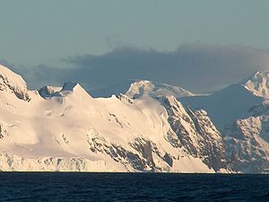
Greenwich Island is an island long and from wide, lying between Robert Island and Livingston Island in the South Shetland Islands. Surface area...
in the South Shetland Islands
South Shetland Islands
The South Shetland Islands are a group of Antarctic islands, lying about north of the Antarctic Peninsula, with a total area of . By the Antarctic Treaty of 1959, the Islands' sovereignty is neither recognized nor disputed by the signatories and they are free for use by any signatory for...
, Antarctica surmounting Wulfila Glacier
Wulfila Glacier
Wulfila Glacier is located on the southern slopes of Breznik Heights, Greenwich Island in the South Shetland Islands, Antarctica and is bounded by Oborishte Ridge to the northwest, Nevlya Peak to the north, Terter Peak and Razgrad Peak to the northeast, and Ephraim Bluff to the southeast...
to the southwest, Solis Glacier
Solis Glacier
Solis Glacier is a glacier on Greenwich Island in the South Shetland Islands, Antarctica extending 2.8 km in southeast-northwest direction and 1.8 km in southwest-northeast direction and draining the north slopes of Breznik Heights to flow northwestwards into Yankee Harbour.The feature...
to the northwest and Zheravna Glacier
Zheravna Glacier
Zheravna Glacier is a glacier on Greenwich Island, Antarctica. The glacier is bounded by Razgrad Peak to the west, Ilinden Peak and Momchil Peak to the north, and Viskyar Ridge to the east, extending 2 km in the east-west direction, and 1.8 km in the north-south direction...
to the southeast.
Location
The peak is located at 62°32′18"S 59°43′03"W which is 740 m northwest of Razgrad PeakRazgrad Peak
Razgrad Peak is an ice-covered peak rising to 550 m in Breznik Heights, Greenwich Island, Antarctica. The peak is located 740 m southeast of Terter Peak, 1.7 km southwest of Momchil Peak, 2.7 km west of the summit of Viskyar Ridge, and 1.51 km north-northeast of the coastal point...
, 1.77 km east-southeast of the summit of Oborishte Ridge
Oborishte Ridge
Oborishte Ridge has an elevation of 340 m in the southwest extremity of Breznik Heights, Greenwich Island in the South Shetland Islands, Antarctica. Extending 1.7 km along the southeast coast of Yankee Harbour and 950 m wide. Ice-free surface area...
, 3.61 km south of Correa Point
Correa Point
Correa Point is a point projecting 350 m into the south part of Discovery Bay from Parvomay Neck, Greenwich Island in the South Shetland Islands, Antarctica with an adjacent ice-free area of...
, 1.77 km west-southwest of Momchil Peak
Momchil Peak
Momchil Peak is an ice-covered peak rising to 625 m in Breznik Heights, Greenwich Island in the South Shetland Islands, Antarctica...
and 2.07 km north of the coastal point formed by Ephraim Bluff
Ephraim Bluff
Ephraim Bluff is a 425 m ice-free bluff in the south of Breznik Heights, Greenwich Island in the South Shetland Islands, Antarctica. The bluff is linked to Razgrad Peak to the north-northeast and separates the termini of Wulfila Glacier to the northwest and Zheravna Glacier to the east.The feature...
(Bulgarian topographic survey Tangra 2004/05
Tangra 2004/05
The Tangra 2004/05 Expedition was commissioned by the Antarctic Place-names Commission at the Ministry of Foreign Affairs of Bulgaria, managed by the Manfred Wörner Foundation, and supported by the Bulgarian Antarctic Institute, the Institute of Mathematics and Informatics at the Bulgarian Academy...
).
The peak is named after Czar Svetoslav Terter of Bulgaria
Bulgaria
Bulgaria , officially the Republic of Bulgaria , is a parliamentary democracy within a unitary constitutional republic in Southeast Europe. The country borders Romania to the north, Serbia and Macedonia to the west, Greece and Turkey to the south, as well as the Black Sea to the east...
, 1300-1321 AD.
Maps
- L.L. Ivanov et al. Antarctica: Livingston Island and Greenwich Island, South Shetland Islands. Scale 1:100000 topographic map. Sofia: Antarctic Place-names Commission of Bulgaria, 2005.
- L.L. Ivanov. Antarctica: Livingston Island and Greenwich, Robert, Snow and Smith Islands. Scale 1:120000 topographic map. Troyan: Manfred Wörner Foundation, 2009. ISBN 978-954-92032-6-4