

Tennyson Down
Encyclopedia
Tennyson Down is a hill at the west end of the Isle of Wight
just south of Totland
. Tennyson Down is a grassy, whale-backed ridge of chalk which rises to 482 ft/147m above sea level. Tennyson Down is named after the poet Lord Tennyson who lived at nearby Farringdon House for nearly 40 years. The poet used to walk on the down almost every day, saying that the air was worth 'sixpence a pint'.
. To the east the hill descends gently down to Freshwater Bay
where the sea has cut through the ridge. To the south is Highdown Cliffs, a near vertical chalk cliff drop of over 100 metres to the sea below.
The top of the Down is fairly flat and is predominately grass downland which provides a wide area for walking. There is some scrubland and small trees mainly on the northern side which is away from the prevailing wind.
The Down is owned and managed by the National Trust
and is grazed by cattle and rabbits which ensures that its grass surface is closely cropped. It is open to the public.
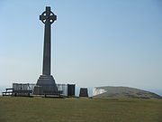 At the top of the Down at a height of 147m stands a huge granite cross commemorating the life of Alfred Lord Tennyson. From here on a clear day it is possible to see Old Harry Rocks
and the Isle of Purbeck
to the west, Yarmouth
and Lymington
to the north, and to the east, much of the Solent
, Fawley Oil Refinery
, a large part of the western half of the Isle of Wight, and St. Catherine's Point, 20 km away across Brighstone Bay
. Surprisingly it is not possible to see the Needles from here as they are hidden beyond the next hill to the west which is known as West High Down.
The Tennyson Trail
, an Isle of Wight footpath, passes right along Tennyson Down and also makes up part of the Isle of Wight Coast Path in this area.
Tennyson Down is one of the most significant downland sites in Britain. It forms the western end of the Tennyson Heritage Coast. It is part of the Headon Warren And West High Down SSSI
(Site of Special Scientific Interest
) and is part of the Isle of Wight’s Area of Outstanding Natural Beauty
.
Isle of Wight
The Isle of Wight is a county and the largest island of England, located in the English Channel, on average about 2–4 miles off the south coast of the county of Hampshire, separated from the mainland by a strait called the Solent...
just south of Totland
Totland
Totland is a village and civil parish at the western tip of the Isle of Wight. It lies on the coast at Colwell Bay, which is the closest part of the island to the British mainland...
. Tennyson Down is a grassy, whale-backed ridge of chalk which rises to 482 ft/147m above sea level. Tennyson Down is named after the poet Lord Tennyson who lived at nearby Farringdon House for nearly 40 years. The poet used to walk on the down almost every day, saying that the air was worth 'sixpence a pint'.
Overview
It is part of the chalk ridge that forms the backbone of the Isle of Wight, this ridge extends to the west for 3 miles (4.8 km) where it ends with The NeedlesThe Needles
The Needles is a row of three distinctive stacks of chalk that rise out of the sea off the western extremity of the Isle of Wight, England, close to Alum Bay. The Needles lighthouse stands at the end of the formation...
. To the east the hill descends gently down to Freshwater Bay
Freshwater, Isle of Wight
Freshwater is a large village and civil parish at the western end of the Isle of Wight, England. Freshwater Bay is a small cove on the south coast of the Island which also gives its name to the nearby part of Freshwater....
where the sea has cut through the ridge. To the south is Highdown Cliffs, a near vertical chalk cliff drop of over 100 metres to the sea below.
The top of the Down is fairly flat and is predominately grass downland which provides a wide area for walking. There is some scrubland and small trees mainly on the northern side which is away from the prevailing wind.
The Down is owned and managed by the National Trust
National Trust for Places of Historic Interest or Natural Beauty
The National Trust for Places of Historic Interest or Natural Beauty, usually known as the National Trust, is a conservation organisation in England, Wales and Northern Ireland...
and is grazed by cattle and rabbits which ensures that its grass surface is closely cropped. It is open to the public.
Old Harry Rocks
The Old Harry Rocks are two chalk sea stacks located at Handfast Point, on the Isle of Purbeck in Dorset, southern England.- Location :Old Harry Rocks lie directly east of Studland, about 4 kilometres northeast of Swanage, and about 10 kilometres south of the large towns of Poole and...
and the Isle of Purbeck
Isle of Purbeck
The Isle of Purbeck, not a true island but a peninsula, is in the county of Dorset, England. It is bordered by the English Channel to the south and east, where steep cliffs fall to the sea; and by the marshy lands of the River Frome and Poole Harbour to the north. Its western boundary is less well...
to the west, Yarmouth
Yarmouth, Isle of Wight
Yarmouth is a port and civil parish in the western part of the Isle of Wight, off the southern coast of mainland England. The town is named for its location at the mouth of the small Western Yar river...
and Lymington
Lymington
Lymington is a port on the west bank of the Lymington River on the Solent, in the New Forest district of Hampshire, England. It is to the east of the South East Dorset conurbation, and faces Yarmouth on the Isle of Wight which is connected to it by a car ferry, operated by Wightlink. The town...
to the north, and to the east, much of the Solent
Solent
The Solent is a strait separating the Isle of Wight from the mainland of England.The Solent is a major shipping route for passengers, freight and military vessels. It is an important recreational area for water sports, particularly yachting, hosting the Cowes Week sailing event annually...
, Fawley Oil Refinery
Fawley Power Station
Fawley Power Station is an oil-fired power station located on the western side of Southampton Water, between the villages of Fawley and Calshot in Hampshire...
, a large part of the western half of the Isle of Wight, and St. Catherine's Point, 20 km away across Brighstone Bay
Brighstone Bay
Brighstone Bay is a bay on the south west coast of the Isle of Wight, England. It lies to the south and west of the village of Brighstone from which it takes its name. It faces south west towards the English Channel, its shoreline is 7 km in length and is gently curving...
. Surprisingly it is not possible to see the Needles from here as they are hidden beyond the next hill to the west which is known as West High Down.
The Tennyson Trail
Tennyson Trail
The Tennyson Trail is a 15 mile walk from Carisbrooke Castle to The Needles on the Isle of Wight. The route follows across Bowcombe Down, through Brighstone Forest, across Mottistone Down, Brook Down & Afton Down to Freshwater Bay, then onto Tennyson Down & across West High Down to Alum Bay...
, an Isle of Wight footpath, passes right along Tennyson Down and also makes up part of the Isle of Wight Coast Path in this area.
Tennyson Down is one of the most significant downland sites in Britain. It forms the western end of the Tennyson Heritage Coast. It is part of the Headon Warren And West High Down SSSI
Headon Warren And West High Down SSSI
Headon Warren And West High Down is a 276.3 hectare Site of special scientific interest which is located at the western most end of the Isle of Wight. It consists of two main areas, Headon Warren, a heather clad down to the north and the chalk downs of West High Down and Tennyson Down to the south....
(Site of Special Scientific Interest
Site of Special Scientific Interest
A Site of Special Scientific Interest is a conservation designation denoting a protected area in the United Kingdom. SSSIs are the basic building block of site-based nature conservation legislation and most other legal nature/geological conservation designations in Great Britain are based upon...
) and is part of the Isle of Wight’s Area of Outstanding Natural Beauty
Isle of Wight AONB
The Isle of Wight Area of Outstanding Natural Beauty is an Area of Outstanding Natural Beauty on the Isle of Wight, England's largest offshore island....
.