
Tennessee State Route 79
Encyclopedia
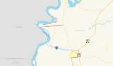
State Route 79 is a 10.37 miles (16.7 km) long state highway in southwestern Lake County, Tennessee. SR 79 has a dual primary & secondary designation and is one of a few state routes in Tennessee to have an aggregate
road surface.
(Island 15) in the extreme southwestern portion of Lake County, Tennessee and travels across low-lying areas that are subject to flooding from the Mississippi River
. SR 79 from its western terminus (mile 0.00) to mile 6.66 has been repeatedly damaged by seasonal flooding and as a result TDOT uses gravel, crushed stone, sand and dirt to rebuild the road surface when it has been damaged from flooding. This section is unsigned
in the field. At mile 6.66, SR 79 crosses the federal levee and is designated as part of Great River Road
from here to its eastern terminus near Ridgely, Tennessee
.
(also known as the Pemiscot Ferry) that crossed the Mississippi River to Caruthersville, Missouri
. This ferry began service in 1895 and was operated by Lee Line Steamers. The roadway geometry of SR 79 has been changed very little since its designation as a state highway with the only major change being at the junction of SR 79 and SR 181
.
Construction Aggregate
Construction aggregate, or simply "aggregate", is a broad category of coarse particulate material used in construction, including sand, gravel, crushed stone, slag, recycled concrete and geosynthetic aggregates. Aggregates are the most mined material in the world...
road surface.
Route description
The western terminus of SR 79 is located at the Mississippi RiverMississippi River
The Mississippi River is the largest river system in North America. Flowing entirely in the United States, this river rises in western Minnesota and meanders slowly southwards for to the Mississippi River Delta at the Gulf of Mexico. With its many tributaries, the Mississippi's watershed drains...
(Island 15) in the extreme southwestern portion of Lake County, Tennessee and travels across low-lying areas that are subject to flooding from the Mississippi River
Mississippi River
The Mississippi River is the largest river system in North America. Flowing entirely in the United States, this river rises in western Minnesota and meanders slowly southwards for to the Mississippi River Delta at the Gulf of Mexico. With its many tributaries, the Mississippi's watershed drains...
. SR 79 from its western terminus (mile 0.00) to mile 6.66 has been repeatedly damaged by seasonal flooding and as a result TDOT uses gravel, crushed stone, sand and dirt to rebuild the road surface when it has been damaged from flooding. This section is unsigned
Unsigned highway
An unsigned highway is a highway that has been assigned a route number, but does not bear conventional road markings that would normally be used to identify the route with that number...
in the field. At mile 6.66, SR 79 crosses the federal levee and is designated as part of Great River Road
Great River Road
The Great River Road is a collection of state, provincial, federal, and local roads which follow the course of the Mississippi River through ten states of the United States...
from here to its eastern terminus near Ridgely, Tennessee
Ridgely, Tennessee
Ridgely is a town in Lake County, Tennessee, United States. The population was 1,667 at the 2000 census.-Geography:Ridgely is located at .According to the United States Census Bureau, the town has a total area of , all of it land....
.
History
SR 79 was known as Powell Ferry Road prior to its designation as a state route and served the Powell FerryFerry
A ferry is a form of transportation, usually a boat, but sometimes a ship, used to carry primarily passengers, and sometimes vehicles and cargo as well, across a body of water. Most ferries operate on regular, frequent, return services...
(also known as the Pemiscot Ferry) that crossed the Mississippi River to Caruthersville, Missouri
Caruthersville, Missouri
Caruthersville is the most populous city and county seat of Pemiscot County, located along the Mississippi River in the bootheel of southeastern Missouri in the United States. The population was 6,760 at the 2000 census.-History:...
. This ferry began service in 1895 and was operated by Lee Line Steamers. The roadway geometry of SR 79 has been changed very little since its designation as a state highway with the only major change being at the junction of SR 79 and SR 181
Tennessee State Route 181
State Route 181 is a primary state highway running through Lake, Dyer, and Lauderdale counties in Tennessee. This highway traverses very sparsely populated areas and is located entirely within the flood plains of the Mississippi River, Obion River and Forked Deer River...
.
Major intersections
| County | Location | Mile | Intersects | Notes | |
|---|---|---|---|---|---|
| Lake | begins at the Mississippi River Mississippi River The Mississippi River is the largest river system in North America. Flowing entirely in the United States, this river rises in western Minnesota and meanders slowly southwards for to the Mississippi River Delta at the Gulf of Mexico. With its many tributaries, the Mississippi's watershed drains... . |
||||
| 6.6 | to | SR 79 changes to primary designation and continues east | |||
| 10.3 | To Reelfoot Lake State Park Reelfoot Lake State Park Reelfoot Lake State Park is a state park in the northwest corner of Tennessee in the United States. It encompasses Reelfoot Lake and is situated in Lake and Obion counties. A major hunting and fishing preserve, it comprises , of which are water, and harbors almost every kind of shorebird, as well... & Reelfoot National Wildlife Refuge Reelfoot National Wildlife Refuge Reelfoot National Wildlife Refuge is a part of the U.S. system of National Wildlife Refuges consisting of an area of Northwest Tennessee and Western Kentucky that consists primarily of a buffer zone around Reelfoot Lake, Tennessee's only large natural lake, which formed after the New Madrid... |
||||