

Tasman Bridge disaster
Encyclopedia
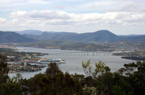
Hobart
Hobart is the state capital and most populous city of the Australian island state of Tasmania. Founded in 1804 as a penal colony,Hobart is Australia's second oldest capital city after Sydney. In 2009, the city had a greater area population of approximately 212,019. A resident of Hobart is known as...
, the capital city of Australia
Australia
Australia , officially the Commonwealth of Australia, is a country in the Southern Hemisphere comprising the mainland of the Australian continent, the island of Tasmania, and numerous smaller islands in the Indian and Pacific Oceans. It is the world's sixth-largest country by total area...
's island state of Tasmania
Tasmania
Tasmania is an Australian island and state. It is south of the continent, separated by Bass Strait. The state includes the island of Tasmania—the 26th largest island in the world—and the surrounding islands. The state has a population of 507,626 , of whom almost half reside in the greater Hobart...
, when a bulk ore carrier travelling up the Derwent River
Derwent River (Tasmania)
The Derwent is a river in Tasmania, Australia. It was named after the River Derwent, Cumbria by British Commodore John Hayes who explored it in 1793. The name is Brythonic Celtic for "valley thick with oaks"....
collided with several pylons of the Tasman Bridge
Tasman Bridge
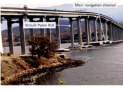
The Tasman Bridge is a five-lane bridge crossing the Derwent River, near the CBD of Hobart, Tasmania. The bridge has a total length of 1,395 metres . It provides the main traffic route from the CBD to the eastern shore - particularly Hobart International Airport and Bellerive Oval...
, causing a large section of the bridge deck to collapse onto the ship and into the river below. Twelve people were killed, including seven crew on board the ship, and the five occupants of four cars which fell 45 m (150 feet) after driving off the bridge. The disaster severed the main link between Hobart and its eastern suburbs, and is notable for the social impacts that resulted from the loss of such an important road artery.
Collision and collapse
MV Lake Illawarra
The MV Lake Illawarra was a Handysize bulk carrier of 7,274 tons in the service of the Australian National Line shipping company. This ship is known for causing the Tasman Bridge disaster when it collided with pylon 19 of Hobart's giant high concrete arch style Tasman Bridge on the evening of...
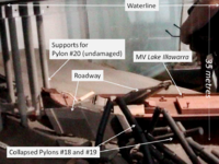
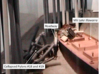
, carrying 10,000 tonnes of zinc ore concentrate, was heading up the Derwent River to offload its cargo to the Electrolytic Zinc Company at Risdon, upstream from Hobart and about 3 km from the bridge. The 1 025m long main viaduct of the bridge comprised a central main navigation span, two flanking secondary navigation spans, and 19 approach spans. The ship was off course as it neared the bridge, partly due to the strong tidal current but also because of inattention by the ship's master, Captain Boleslaw Pelc. Initially approaching the bridge at eight knots, Pelc slowed the ship to a 'safe' speed. Although the Lake Illawarra was capable of passing through the bridge's central navigation span, the captain attempted to pass through one of the eastern spans.
Despite several changes of course, the ship proved unmanageable due to its insufficient speed relative to the current. In desperation the captain ordered 'full speed astern', at which point all control was lost. The vessel drifted towards the bridge midway between the central navigation span and the eastern shore, crashing into the pile capping of piers 18 and 19, bringing three unsupported spans and a 127 m section of roadway crashing into the river and onto the vessel's deck. The ship listed to starboard and sank within minutes in 35 m of water a short distance to the south. Seven crew members on the Lake Illawarra were trapped and drowned. The subsequent marine court of inquiry found that the captain had not handled the ship in a proper and seamanlike manner, and his certificate was suspended for 6 months.
As the collision occurred on a Sunday evening, there was relatively little traffic on the bridge. While no cars were travelling between the 18th and 19th pylons when that section collapsed, four cars drove over the gap, killing five occupants. Two drivers managed to stop their vehicles at the edge, but not before their front wheels had dropped over the lip of the bridge deck. One of these cars contained Frank and Sylvia Manley, travelling with two young children in the back seat.
Sylvia Manley: "As we approached, it was a foggy night...there was no lights on the bridge at the time. We just thought there was an accident. We slowed down to about 40 km/h and I'm peering out the window, desperately looking to see the car...what was happening on the bridge. We couldn't see anything but we kept on travelling. The next thing, I said to Frank, "The bridge is gone!" And he just applied the brakes and we just sat there swinging. As we sat there, we couldn’t see anything in the water. All we could see was a big whirlpool of water and apparently the boat was sinking. So with that, we undid the car door and I hopped out."
Frank Manley: "[Sylvia] said “The white line, the white line’s gone. Stop!" I just hit the brakes and I said “I can’t, I can’t, I can’t stop.” And next thing we just hung off the gap...when I swung the door open, I could see, more or less, see the water...and I just swung meself towards the back of the car and grabbed the headrest like that to pull myself around. There's a big automatic transmission pan underneath [the car] - that's what it balanced on."
Emergency response
Private citizens living nearby were on the scene early, even before the ship had sunk. Three of these were Jack Read in his H28 yacht "Mermerus", David Read in a small launch, and Jerry Chamberlain, who had their boats moored in Montagu Bay close by. These and others, and many shore based residents were responsible for saving many of the crewmen from the Lake Illawarra. Those in small craft acted alone in very difficult circumstances with falling hunks of cement, live wires, and a torrent of water from a broken water main above, until the water police arrived on the scene. A large number of other organisations were involved in the emergency response, including police, ambulance service, fire brigade, Royal Hobart HospitalRoyal Hobart Hospital
The Royal Hobart Hospital is a public hospital located the in Hobart CBD, Tasmania, Australia. The RHH also functions as a teaching hospital in co-operation with University of Tasmania. The hospital's research facilities are known as the RHH Research Foundation.The hospital is run by the Tasmanian...
, Civil Defence, the Hobart Tug Company, Marine Board of Hobart, Public Works Department, Transport Commission, HydroElectric Commission, Hobart Regional Water Board, the Australian Army
Australian Army
The Australian Army is Australia's military land force. It is part of the Australian Defence Force along with the Royal Australian Navy and the Royal Australian Air Force. While the Chief of Defence commands the Australian Defence Force , the Army is commanded by the Chief of Army...
and the Royal Australian Navy
Royal Australian Navy
The Royal Australian Navy is the naval branch of the Australian Defence Force. Following the Federation of Australia in 1901, the ships and resources of the separate colonial navies were integrated into a national force: the Commonwealth Naval Forces...
. At 2:30 am, a 14-man Navy Clearance Diving Team
Clearance Diving Team (RAN)
The Clearance Diving Teams of the Royal Australian Navy also act as commando frogmen: they consist of naval personnel who are qualified in diving, demolitions, underwater repairs, and reconnaissance...
flew to Hobart to assist Water Police in the recovery of the vehicles which had driven off the bridge. Two vehicles were identified on 7 January; one salvaged that day and the second three days later. Another vehicle was found buried under rubble on 8 January.
A comprehensive survey of the wreck of the Lake Illawarra was completed by 13 January. The divers operated in hazardous conditions, with minimal visibility and strong river currents, contending with bridge debris such as shattered concrete, reinforced steel rods, railings, pipes, lights, wire and power cables. Strong winds on the third day brought down debris from the bridge above, including power cables, endangering the divers working below.
Known deceased
A total of twelve people died in the disaster, seven crew of the MV Lake Illawarra and five motorists.From the ship, Clarence Madigan (52), Thomas Sheridan (50), Louis Mendizabil (54), Angus Campbell (64) and Arthur Robinson (82) are known to have perished through drowning.
Motorists that perished by driving over the gap in the bridge were Lauderdale couple Anthony Sward (27) and Pamela Sward (26), Robert Rezek (24) of Bellerive and Joyce Stokoe (60) of Lindisfarne.
All suffered massive trauma injuries and died as a result of their vehicles falling from a height to the River Derwent below.
A divided city
Facilities
The collapse of Tasman Bridge isolated two sides of the city which had heavily relied upon it for most daily activities. 30% of Hobart's residents lived on the eastern shore and were effectively isolated. The day after the incident, as some 30,000 residents set out for work, they found that the former three-minute commute over the bridge had turned into a ninety-minute trip. Within an hour of the incident, the Sullivans Cove Ferry Company started services between both shores of the river, and continued their services throughout the night.Three private ferries and a government vessel were in place the next day. People on the Eastern Shore quickly became isolated, as most schools, hospitals, businesses and government offices were located on the Western Shore. Prior to the disaster, many services on the eastern shore were severely lacking. Access to medical services in particular, posed problems for residents in the east, as services consisted only of local clinics. Hobart's hospitals—the Royal Hobart Hospital
Royal Hobart Hospital
The Royal Hobart Hospital is a public hospital located the in Hobart CBD, Tasmania, Australia. The RHH also functions as a teaching hospital in co-operation with University of Tasmania. The hospital's research facilities are known as the RHH Research Foundation.The hospital is run by the Tasmanian...
and the Calvary Hospital
Calvary Hospital, Hobart
Calvary Hospital is a Catholic not-for-profit private hospital, located in Lenah Valley, Hobart, Tasmania.Calvary provides specialised treatment in the areas of orthopaedic surgery, urology, gynaecology, neurosurgery, paediatric surgery, plastic surgery, vascular surgery, cardiology, respiratory...
—were located on the Western Shore. What was previously a short drive across the river became a 50 km (31.1 mi) trip via the estuary's other bridge in Bridgewater
Bridgewater, Tasmania
Bridgewater, Tasmania, is one greater Hobart's northern-most suburbs, located 19 km from the city. It is situated on the eastern shore of the Derwent River. It is a suburb of the local government area of the Municipality of Brighton....
. Most of Hobart's cultural activities, such as theatres, cinemas, the museum and art gallery, restaurants, meeting places, lecture theatres and the botanical gardens, were located on the western shore.
Social effects
The disaster caused a variety of social and psychological difficulties. Although comparatively minor in loss of life and damage, it presented a problem beyond the capacity of the community to resolve. The disaster had a number of unique characteristics and occurred at a time when the effects of disasters on communities were not well understood. Opportunities for the community to be involved in the response to the disaster and the physical restoration of infrastructure were minimal because of the nature of the event. It is likely that this lack of community involvement contributed to the enduring nature of the effects of the disaster on a number of individuals.A study of police data found that in the six months after the disaster, crime rose 41% on the eastern shore, while the rate on the city's western side fell. Car theft rose almost 50% in the isolated community, and neighborhood quarrels and complaints rose 300%. Frustration and anger was directed towards the transport services. Visible progress on restoration of the bridge was slow because of the need for extensive underwater surveys of debris and the time required for design of the rebuilding. The ferry queues did however provide some assistance by providing a forum where people with much in common could vent their frustration. A sociological study described how the physical isolation led to debonding (the setting aside of bonds that constitute the fabric of normal social life). The loss of the Tasman Bridge in Hobart disconnected two parts of the city and had far reaching effects on the people separated.
Repairing the Tasman Bridge
Bailey bridge
The Bailey bridge is a type of portable, pre-fabricated, truss bridge. It was developed by the British during World War II for military use and saw extensive use by both British and the American military engineering units....
788 m long, linking the eastern and western shores of the Derwent, was opened.
Specialists in marine engineering undertook an extensive investigation to locate bridge debris. This survey took a number of months to complete, and parts of the bridge weighing up to 500 tons were accurately located using equipment developed by the University of Tasmania and the Public Works Department. Maunsell and Partners were appointed consultants for the rebuilding project. The firm John Holland was awarded the construction contract. Engineers decided not to replace pier 19 as there was too much debris on the site. The Tasman Bridge was re-opened on 8 October 1977, nearly three years after its collapse. The annual expenditures on the Tasman Bridge reconstruction were $1.7 m in 1974–75; $12.3 m in 1975–76; $13.2 m in 1976–77 and $6.1m in 1977–78.
The engineering design of the Tasman Bridge provided impact absorbing fendering to the pile caps of the main navigation span capable of withstanding a glancing collision by a large ship, but all other piers were unprotected. This disaster shares some common features with the Skyway Bridge collapse
Sunshine Skyway Bridge
The Bob Graham Sunshine Skyway Bridge is a bridge spanning Tampa Bay, Florida, with a cable-stayed main span, and a total length of 21,877 feet . It is part of I-275 and US 19 , connecting St. Petersburg in Pinellas County and Terra Ceia in Manatee County, Florida, passing through Hillsborough...
in Florida in 1980, and the I-40 Bridge Disaster in Oklahoma in 2002, both involving collisions with ships. When river traffic "comprises large vessels, even at low speed, the consequences of pier failure can be catastrophic". In the field of structural engineering, the concept of ‘pier-redundant’ bridges refers to a bridge superstructure which does not collapse when a single pier is removed. Two ‘pier-redundant’ bridges have been constructed in Australia - over the Murray River at Berri and at Hindmarsh Island in South Australia. The probability of ship impact is now regularly evaluated by specialist consultants when designing major bridges. One solution is to protect bridge piers through strengthening or the construction of impact-resistant barriers
The disaster resulted in changes to the regulations pertaining to shipping movements on the Derwent River. The Marine and Safety (Pilotage and Navigation) Regulations (2007) contains specific provisions dealing with the Bridge, e.g.:
"The master of a vessel approaching the Bridge to navigate it through a span must (a) have the vessel fully under control; and (b) navigate the vessel with all possible care at the minimum speed required to pass safely under the bridge".
Vessels above a certain size are required to be piloted, and vehicle movements on the bridge are temporarily halted when large vessels are to pass underneath the bridge. As an added precaution, it is now mandatory for most large vessels to have a tug in attendance as they transit the bridge in the event that assistance with steerage may be needed.
Development on the eastern shore

A new bridge crossing the river, the Bowen Bridge
Bowen Bridge
The Bowen Bridge is a four-lane road bridge crossing the Derwent River in Tasmania, Australia. The Bridge lies on the river approximately half way between the Tasman Bridge and the Bridgewater Bridge. The Bridge links the East Derwent Highway with the Brooker Highway at Glenorchy some 10...
, was completed in 1984, a few kilometres north of the Tasman Bridge.
Memorial
Jim Bacon
James Alexander Bacon, AC was Premier of Tasmania from 1998 to 2004.-Early life:Bacon was born in Melbourne; his father Frank, a doctor, died when Jim was twelve, leaving him to be raised by his mother Joan. He was educated at Scotch College and later at Monash University, but he did not graduate....
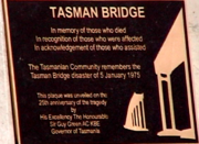
stated that some people were still struggling with the memories of its effects, and he commended the resilience of the community in coping with the disaster. The Governor at the time, Sir Guy Green, described the pain and loss of loved ones and the social and economic disruption. He paid tribute to the efforts of emergency services personnel in responding to the disaster. He said that the "eastern shore had emerged more self-sufficient in the wake of the tragedy" and that "Tasmanians were now stronger, more self-reliant and mature". A plaque commemorating the tragedy
Tragedy (event)
A tragedy is an event in which one or more losses, usually of human life, occurs that is viewed as mournful. Such an event is said to be tragic....
was affixed to the main bridge support on the eastern shoreline.
Further reading
- Lewis, T. By Derwent divided: the story of Lake Illawarra, the Tasman Bridge and the 1975 disaster. Darwin : Tall Stories, 1999. ISBN 0957735111
- Ludeke, M. Ten events shaping Tasmania's history. Hobart, Tas. : Ludeke, 2006 ISBN 0957928424
- Johnson, S. "Over the Edge!" Reader's Digest, Nov. 1977.