

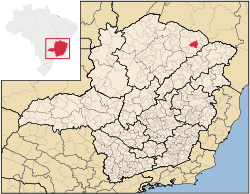
Taiobeiras
Encyclopedia
Minas Gerais
Minas Gerais is one of the 26 states of Brazil, of which it is the second most populous, the third richest, and the fourth largest in area. Minas Gerais is the Brazilian state with the largest number of Presidents of Brazil, the current one, Dilma Rousseff, being one of them. The capital is the...
in Brazil
Brazil
Brazil , officially the Federative Republic of Brazil , is the largest country in South America. It is the world's fifth largest country, both by geographical area and by population with over 192 million people...
. As of 2007 the population was 29,732 in an area of 1,194 km². The elevation of the municipal seat is 821 meters. It became a municipality in 1953. The postal code (CEP) is 39550-000 and it belongs to the statistical microregion of Salinas
Salinas, Minas Gerais
Salinas is a municipality in the northeast of the Brazilian state of Minas Gerais. Its population in 2007 was 37,370 inhabitants in a total area of 1,897 km².-Important facts and Distances:...
Taiobeiras is located 44 km. north of Salinas on highway MG-404. It is 704 km. to the state capital, Belo Horizonte
Belo Horizonte
Belo Horizonte is the capital of and largest city in the state of Minas Gerais, located in the southeastern region of Brazil. It is the third largest metropolitan area in the country...
.
Neighboring municipalities are:
- West: Rio Pardo de MinasRio Pardo de MinasRio Pardo de Minas is a municipality in the northeast of the Brazilian state of Minas Gerais. Its population in 2007 was 28,633 inhabitants in a total area of 3,119 km².-Important facts and Distances:...
, - North: IndaiabiraIndaiabiraIndaiabira is a municipality in the northeast of the Brazilian state of Minas Gerais. As of 2007 the population was 7,482 in a total area of 1,008 km². The elevation is 857 meters. It became a municipality in 1997....
and São João do ParaísoSão João do ParaísoSão João do Paraíso is a city in the northeast of the Brazilian state of Minas Gerais. In 2007 its population was estimated to be 21,839 in a total area of 1,921 km².... - East: BerizalBerizalBerizal is a Brazilian municipality located in the northeast of the state of Minas Gerais. As of 2007 the population was 4,399 in a total area of 493 km²....
and Curral de DentroCurral de DentroCurral de Dentro is a municipality in the northeast of the Brazilian state of Minas Gerais. As of 2007 the population was 6,907 in a total area of 571 km². The elevation is 890 meters. It became a municipality in 1997....
, - South: Santa Cruz de SalinasSanta Cruz de SalinasSanta Cruz de Salinas is a municipality in the northeast of the Brazilian state of Minas Gerais. Its population in 2007 was 5,192 inhabitants in a total area of 587 km²....
and SalinasSalinas, Minas GeraisSalinas is a municipality in the northeast of the Brazilian state of Minas Gerais. Its population in 2007 was 37,370 inhabitants in a total area of 1,897 km².-Important facts and Distances:...
The economy is based on agriculture with some cattle raising. There were 18,000 head in 2006. The main agricultural crops were coffee, bananas, citrus fruits, mangoes, tomatoes, and corn. The GDP was R$100,657,000 in 2005. In 2006, there were 1,221 rural establishments employing 1,200 salaried workers. The total agricultural land area was 90,819 hectares. There were 2 banking agencies in the urban area.
This municipality is isolated from major population centers and suffers from drought and poor soils.
- Municipal Human Development IndexHuman Development IndexThe Human Development Index is a composite statistic used to rank countries by level of "human development" and separate "very high human development", "high human development", "medium human development", and "low human development" countries...
: .700 (2000) - State ranking: 544 out of 853 municipalities as of 2000
- National ranking: 2,998 out of 5,138 municipalities as of 2000
- Health clinics and hospitals: 2 basic clinics, 8 health centers, and 1 hospital with 65 beds
The social and health indicators were: degree of urbanization--79.7%; Illiteracy rate: 26.8%; coverage of sewage system in the urban area--0.60%; coverage of garbage collection in the urban area--85.4; and infant mortality--19.60.