

Rio Pardo de Minas
Encyclopedia
Brazil
Brazil , officially the Federative Republic of Brazil , is the largest country in South America. It is the world's fifth largest country, both by geographical area and by population with over 192 million people...
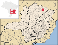
ian state of Minas Gerais
Minas Gerais
Minas Gerais is one of the 26 states of Brazil, of which it is the second most populous, the third richest, and the fourth largest in area. Minas Gerais is the Brazilian state with the largest number of Presidents of Brazil, the current one, Dilma Rousseff, being one of them. The capital is the...
. Its population in 2007 was 28,633 inhabitants in a total area of 3,119 km².
Important facts and Distances
The elevation is 751 meters. It became a municipality in 1831. The postal code (CEP) is 39530-000. Population density was a little over 18 inhab/km². Rio Pardo de Minas is located on dirt roads (MG-342), 70 km. northwest of SalinasSalinas, Minas Gerais
Salinas is a municipality in the northeast of the Brazilian state of Minas Gerais. Its population in 2007 was 37,370 inhabitants in a total area of 1,897 km².-Important facts and Distances:...
. The Rio Pardo flows through the town. It is part of the statistical microregion of Salinas
Salinas, Minas Gerais
Salinas is a municipality in the northeast of the Brazilian state of Minas Gerais. Its population in 2007 was 37,370 inhabitants in a total area of 1,897 km².-Important facts and Distances:...
.
Neighboring municipalities
- Neighboring municipalities are: NovorizonteNovorizonteNovorizonte is a municipality in the northeast of the Brazilian state of Minas Gerais. Its population in 2007 was 4,899 inhabitants in a total area of 264 km²....
, Fruta de LeiteFruta de LeiteFruta de Leite is a municipality in the northeast of the Brazilian state of Minas Gerais. As of 2007 the population was 6,327 in a total area of 758 km². The elevation is 910 meters. It became a municipality in 1997. The postal code is 39558-000....
, Mato VerdeMato VerdeMato Verde is a city and municipality located in the north of the state of Minas Gerais in Brazil. It was founded in 1953. The population was 12,664 as of 2007 and the area was 664 km². The elevation of the city is 541 metres. The postal code is 39527-000.Mato Verde is part of the...
, PorteirinhaPorteirinhaPorteirinha is a municipality in the northern region of Minas Gerais, Brazil. The population in 2007 was 36,864 in an area of 1,806 km². The elevation is 566 meters. It became a municipality in 1938. The postal code is 39520-000....
, Serranópolis de MinasSerranópolis de MinasSerranópolis de Minas is a municipality in the northern region of Minas Gerais, Brazil. The population in 2007 was 4,515 in an area of 553 km². The elevation is 555 meters. It became a municipality in 1997. The postal code is 39518-000....
, Riacho dos MachadosRiacho dos MachadosRiacho dos Machados is a municipality in the northern region of Minas Gerais, Brazil. The population in 2007 was 9,392 in an area of 1,309 km². The elevation is 821 meters. It became a municipality in 1962. The postal code is 39529-000....
, Grão MogolGrão MogolGrão Mogol is a Brazilian municipality located in the north of the state of Minas Gerais. In 2007 the population was 14,954 in a total area of 3,890 km². The elevation is 829 meters. It became a municipality in 1840.-Location and Distances:...
, Padre CarvalhoPadre CarvalhoPadre Carvalho is a Brazilian municipality located in the north of the state of Minas Gerais. In 2007 the population was 5,828 in a total area of 450 km². It became a municipality in 1997.-Location and Distances:...
, SalinasSalinas, Minas GeraisSalinas is a municipality in the northeast of the Brazilian state of Minas Gerais. Its population in 2007 was 37,370 inhabitants in a total area of 1,897 km².-Important facts and Distances:...
, IndaiabiraIndaiabiraIndaiabira is a municipality in the northeast of the Brazilian state of Minas Gerais. As of 2007 the population was 7,482 in a total area of 1,008 km². The elevation is 857 meters. It became a municipality in 1997....
, Vargem Grande do Rio PardoVargem Grande do Rio PardoVargem Grande do Rio Pardo is a municipality in the northeast of the Brazilian state of Minas Gerais. As of 2007 the population was 4,703 in a total area of 494 km². The elevation is 800 meters...
, MontezumaMontezuma, Minas GeraisMontezuma is a municipality in the northeast of the Brazilian state of Minas Gerais. As of 2007 the population was 7,259 in a total area of 1,134 km². The elevation is 850 meters. It became a municipality in 1993....
and Santo Antônio do RetiroSanto Antônio do RetiroSanto Antônio do Retiro is a city in the northeast of the Brazilian state of Minas Gerais. In 2007 its population was estimated to be 6,817 in a total area of 797 km²....
.
The economy
The main economic activities are cattle raising (10,000 head in 2006), small industries and agriculture. The main crops are bananas, citrus fruits, beans, sugarcane, tomatoes, and corn. In the rural area there were 3,205 producers on 75,000 ha. Natural pasture made up 18,000 ha, woodland 33,000 ha. and planted area 11,500 ha. Around 10,500 persons worked in agriculture. The GDP in 2003 was R$64,482,000 while the per capita GDP was R$2,319. In 2006 there was one bank. Health needs were taken care of by 11 municipal health centers, one private health center and one hospital with 42 beds.Health and education
This municipality is isolated from major population centers and suffers from drought and poor soils.- Municipal Human Development IndexHuman Development IndexThe Human Development Index is a composite statistic used to rank countries by level of "human development" and separate "very high human development", "high human development", "medium human development", and "low human development" countries...
: .633 (2000) - State ranking: 787 out of 853 municipalities as of 2000
- National ranking: 4,072 out of 5,138 municipalities as of 2000