
Sítio d'Abadia
Encyclopedia
| Sítio d'Abadia | |
|---|---|
| State | Goiás Goiás Goiás is a state of Brazil, located in the central part of the country. The name Goiás comes from the name of an indigenous community... |
| Geographical Coordinates: | 14°48′14"S 46°15′01"W |
| Area: | 1,598.3 km² |
| Population: | 3,251 (IBGE 2007) |
| Elevation: | 748m above sea level |
| Postcode (CEP): | 73990-000 |
| IBGE statistical microregion: | 011 Vão do Paranã |
| Became a city: | 1850 |
| Mayor: | Kesser Vieira Reis |
| Distance to Goiânia Goiânia -Climate:The city has a tropical wet and dry climate with an average temperature of . There's a wet season, from October to April, and a dry one, from May to September. Annual rainfall is around 1,520 mm.... : |
561 km. |
| Website: | none |
Town
A town is a human settlement larger than a village but smaller than a city. The size a settlement must be in order to be called a "town" varies considerably in different parts of the world, so that, for example, many American "small towns" seem to British people to be no more than villages, while...
and municipality
Municipality
A municipality is essentially an urban administrative division having corporate status and usually powers of self-government. It can also be used to mean the governing body of a municipality. A municipality is a general-purpose administrative subdivision, as opposed to a special-purpose district...
in eastern Goiás
Goiás
Goiás is a state of Brazil, located in the central part of the country. The name Goiás comes from the name of an indigenous community...
state, Brazil
Brazil
Brazil , officially the Federative Republic of Brazil , is the largest country in South America. It is the world's fifth largest country, both by geographical area and by population with over 192 million people...
.
Location
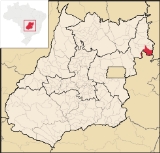
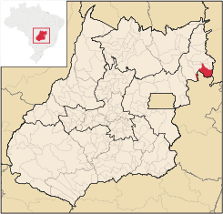
Sítio d'Abadia is located in a corner of eastern GoiásGoiás
Goiás is a state of Brazil, located in the central part of the country. The name Goiás comes from the name of an indigenous community...
, 14 kilometers north of the border with Minas Gerais
Minas Gerais
Minas Gerais is one of the 26 states of Brazil, of which it is the second most populous, the third richest, and the fourth largest in area. Minas Gerais is the Brazilian state with the largest number of Presidents of Brazil, the current one, Dilma Rousseff, being one of them. The capital is the...
. It is about 30 kilometers west of the border with Bahia
Bahia
Bahia is one of the 26 states of Brazil, and is located in the northeastern part of the country on the Atlantic coast. It is the fourth most populous Brazilian state after São Paulo, Minas Gerais and Rio de Janeiro, and the fifth-largest in size...
. It is one of the most isolated towns in the state of Goiás
Goiás
Goiás is a state of Brazil, located in the central part of the country. The name Goiás comes from the name of an indigenous community...
, and can be accessed only by paved highway by driving north to Damianópolis
Damianópolis
Damianópolis is a small town and municipality in eastern Goiás state, Brazil. The population was 3,597 in a total area of 415.3 km².-Location:...
. It belongs to the Vão do Paranã statistical micro-region.
The distance to Goiânia
Goiânia
-Climate:The city has a tropical wet and dry climate with an average temperature of . There's a wet season, from October to April, and a dry one, from May to September. Annual rainfall is around 1,520 mm....
is 561 km. Highway connections are made by BR-153 / Anápolis
Anápolis
Anápolis is the third largest city in the State of Goiás in Brazil. It lies in the center of a rich agricultural region and has become a leader in food processing and pharmaceutical plants.-Location and population:...
/ GO-060 / Alexânia
Alexânia
Alexânia is a small town and municipality in central Goiás state, Brazil. Alexânia is known for its alleged extraterrestrial sightings in the late sixties and early seventies. The Areias River passes through the municipality.-Location:...
/ Planaltina
Planaltina
Planaltina is one of the administrative districts of the Federal District of Brazil, with an area of 1,534 kmª and a population of 147,114 in 2000, of whom 134,663 were classified as urban and 12,451 as rural...
/ Formosa
Formosa, Goiás
Formosa is a city and municipality located in the state of Goiás, Brazil, approximately 80 kilometers east of Brasília. The population was 90,247 in a total area of 5,806.89 km² . Formosa is known for its waterfalls and natural beauty...
/ GO-020 / BR-030 / Vila Boa
Vila Boa, Goiás
Vila Boa is a small town and municipality in northeastern Goiás state, Brazil.-Location:Vila Boa is located on the extreme northeast limit of the Entorno de Brasília microregion. The nearest major population center is Formosa, which is 95 km. to the southeast...
/ Alvorada do Norte
Alvorada do Norte
Alvorada do Norte is a small town and municipality in northeastern Goiás state, Brazil. It is an important commercial center on the Brasília-Salvador highway.-Location:...
/ GO-236 / Buritinópolis
Buritinópolis
Buritinópolis is a small town and municipality in eastern Goiás state, Brazil. It is the poorest municipality in the state.-Location:Buritinópolis is located in the Vão do Paranã statistical micro-region in the area near Simolândia and Alvorada do Norte. It is close to the important BR-020...
/ Mambaí
Mambaí
Mambaí is a city in eastern Goiás state, Brazil. It is the easternmost city in that state.-Geography:Mambaí is one of the most isolated cities in the state of Goiás. It lies in the Vão do Paranã statistical micro-region less than 20 kilometers from the border with the state of Bahia. It is 61...
/ GO-108 / Damianópolis
Damianópolis
Damianópolis is a small town and municipality in eastern Goiás state, Brazil. The population was 3,597 in a total area of 415.3 km².-Location:...
.
Municipal boundaries are with:
- north: Alvorada do NorteAlvorada do NorteAlvorada do Norte is a small town and municipality in northeastern Goiás state, Brazil. It is an important commercial center on the Brasília-Salvador highway.-Location:...
and DamianópolisDamianópolisDamianópolis is a small town and municipality in eastern Goiás state, Brazil. The population was 3,597 in a total area of 415.3 km².-Location:... - west: Flores de GoiásFlores de GoiásFlores de Goiás is a small town and municipality in northeastern Goiás state, Brazil.-Geography:Located in the Vão do Paranã statistical micro-region, Flores has boundaries with Buritis, Sítio d'Abadia, Vila Boa, Alvorada do Norte, Iaciara, Nova Roma, São João d'Aliança, Formosa and Alto Paraíso...
- south: Minas GeraisMinas GeraisMinas Gerais is one of the 26 states of Brazil, of which it is the second most populous, the third richest, and the fourth largest in area. Minas Gerais is the Brazilian state with the largest number of Presidents of Brazil, the current one, Dilma Rousseff, being one of them. The capital is the...
- east: BahiaBahiaBahia is one of the 26 states of Brazil, and is located in the northeastern part of the country on the Atlantic coast. It is the fourth most populous Brazilian state after São Paulo, Minas Gerais and Rio de Janeiro, and the fifth-largest in size...
Demographics
- Population density: 2.03 inhab/km² (2007)
- Urban/Rural population: 1,034/2,217
- Population growth rate 1996/2007: 1.07%
Economy
The economy is based on modest services, public administration, agriculture and cattle raising. There were no banks and 13 commercial establishments in August 2007. There were 52 automobiles in 2007. In 2006 there were 29,000 head of cattle. The main agricultural products were rice, bananas, sugarcane, manioc, beans, corn, and soybeans (2,000 hectares planted).- Motor vehicles: 80 (automobiles and pickup trucks)
- Number of inhabitants per motor vehicle: 41
Agricultural data 2006
- Farms: 499
- Total area: 90,612 ha.
- Area of permanent crops: 127 ha.
- Area of perennial crops: 5,272 ha.
- Area of natural pasture: 67,823 ha.
- Area of woodland and forests: 16,693 ha.
- Persons dependent on farming: 1,550
- Tractors: 97
- Cattle herd: 29,000
- Main crops: soybeans on 2,000 hectares
Health and education
- Literacy rate: 74.4
- Infant mortality rate: 36.25 for 1000 live births
- Life expectancy:
- Hospitals: none
- Schools: 8 with 1,020 students
Sítio d'Abadia is a very poor town in one of the poorest areas of the state. In 2000 it was ranked 235 out of 242 municipalities in the state of Goiás
Goiás
Goiás is a state of Brazil, located in the central part of the country. The name Goiás comes from the name of an indigenous community...
on the United Nations Human Development Index
Human Development Index
The Human Development Index is a composite statistic used to rank countries by level of "human development" and separate "very high human development", "high human development", "medium human development", and "low human development" countries...
with a score of 0.643. Nationally it was ranked 3,875 out of 5,507 municipalities.
Tourism
Sítio d'Abadia has one of the largest waterfalls in the state located on the Rio Corrente. See Cachoeiras d'Abadia
See also
- List of municipalities in Goiás
- Vão do Paranã MicroregionVão do Paranã MicroregionThe Vão do Paranã is a statistical micro-region created by IBGE in northeastern Goiás state, Brazil.*Population: 102,927 inhabitants *Cities: 12...
- Microregions in GoiásMicroregions in GoiásThe state of Goiás is divided into 18 statistical microregions by the Instituto Brasileiro de Geografia e Estatístic . These have no administrative function but are used only for statistics...