

Swan Range
Encyclopedia
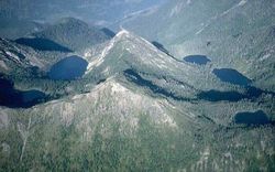
The Swan Range is a mountain range in western Montana
in the United States 47°43′30"N 113°37′35"W. Its peaks typically rise to around 8000 to 9000 ft (2,438.4 to 2,743.2 m). The range is bounded by the South Fork Flathead River
to the east, the Flathead River
to the north and northwest, the Swan River
to the west, and lie to the southwest of Glacier National Park, just south of the U.S.-Canada border. It runs about 99 miles (159.3 km) from north-northwest to south-southeast. Some major cities near the Swan Range include Kalispell
and Bigfork
to the northeast, and Seeley Lake
on the south.
and the north-flowing, 93 miles (149.7 km) Swan River
on its west side. There are two theories to the origin of this name. One theory is that Swan Lake was once populated with trumpeter swan
s, but none are found there today. The second is that the river, range and lake were named after Emmett Swan, a long-time resident of the Swan River area.
to the east and northeast. It is about 99 miles (159.3 km) north to south and 66 miles (106.2 km) in breadth. The highest peak is Holland Peak, 9356 feet (2,851.7 m) in height. The South Fork Flathead River
runs for 98 miles (157.7 km) northwards along the east side of the range, providing drainage for almost all streams east of the Swan Range's drainage divide. The Hungry Horse Reservoir, formed by Hungry Horse Dam
, lies to the northeast and is about 50 miles (80.5 km) in length. The main Flathead River
cuts across the north part of the range, severing it from the Whitefish Range
, forming "Bad Rock Canyon". The range is part of the Pend Oreille River
drainage basin, which eventually drains to the Columbia River
.
 Flathead Lake
, much larger than Hungry Horse Reservoir, adjoins to the south the broad, flat valley that lies to the northeast of the Swan Range. Swan Lake, which is cited by some to be the source of the name of the range, feeds the Swan River which flows into the southwest end and issues from its north end. The Swan River forms much of the western boundary of the range, flowing through a broad valley between the Swan and Mission ranges. The Swan Range's boundary with the Flathead Range slowly diminishes as it progresses south - it is in the middle and north parts that this boundary is clearly distinguished. Many of the valleys dissecting the Swan Range drain into the South Fork of the Flathead - the water divide of the range lies more to the west.
The range is most commonly stated to top out at 9000 feet (2,743.2 m), but the National Geographic Society
and some early sources place Swan Peak - the second highest mountain in the range - at 11000 feet (3,352.8 m), and state that it is the highest mountain. "The range to the east of [the Swan River valley] is the Swan Range. It is the highest and least broken ridge in the region, the higher peaks rising to ten and eleven thousand feet."
Listed from north to south, the cities and towns bordering the Swan Range are Columbia Falls
, La Salle, Creston, Bigfork
, Seeley Lake
and Lincoln
. While the southern part lies in the Bob Marshall Wilderness
and the east part is largely undeveloped, the west side parallels an almost continuous agricultural valley and also Montana Highway 83
.
Montana
Montana is a state in the Western United States. The western third of Montana contains numerous mountain ranges. Smaller, "island ranges" are found in the central third of the state, for a total of 77 named ranges of the Rocky Mountains. This geographical fact is reflected in the state's name,...
in the United States 47°43′30"N 113°37′35"W. Its peaks typically rise to around 8000 to 9000 ft (2,438.4 to 2,743.2 m). The range is bounded by the South Fork Flathead River
South Fork Flathead River
The South Fork Flathead River is a major river in Northwestern Montana in the northwest United States. It is one of the three main forks of the Flathead River, a tributary of the Clark Fork River...
to the east, the Flathead River
Flathead River
The Flathead River, in the northwestern part of the U.S. state of Montana, originates in the Rocky Mountains near Glacier National Park and flows southwest into Flathead Lake, then after a journey of , empties into the Clark Fork. The river is part of the Columbia River drainage basin, as the Clark...
to the north and northwest, the Swan River
Swan River (Montana)
The Swan River in the western part of the U.S. state of Montana starts in the Mission Mountains at Gray Wolf Lake and continues north to Swan Lake. Then it goes west and is impounded by a dam before emptying into Bigfork Bay and the town of Bigfork, where it enters Flathead Lake. The last stretch...
to the west, and lie to the southwest of Glacier National Park, just south of the U.S.-Canada border. It runs about 99 miles (159.3 km) from north-northwest to south-southeast. Some major cities near the Swan Range include Kalispell
Kalispell, Montana
Kalispell is a city in and the county seat of Flathead County, Montana, United States. The 2010 census put Kalispell's population at 19,927 up 5,704 over 2000. At 40.1% this is the largest percentage of growth of any incorporated city in Montana. Kalispell is the largest city and commercial center...
and Bigfork
Bigfork, Montana
Bigfork is a census-designated place in Flathead County, Montana, United States. The population was 1,421 at the 2000 census.-Geography:Bigfork is located at ....
to the northeast, and Seeley Lake
Seeley Lake, Montana
Seeley Lake is a census-designated place in Missoula County, Montana, United States. It is part of the 'Missoula, Montana Metropolitan Statistical Area'...
on the south.
Etymology
The range shares its name with Swan LakeSwan Lake (Montana)
Swan Lake is a lake located east of Flathead Lake and the town of Bigfork, Montana. The Swan River comes from the south and fills the lake. The lake is similar to Moyie Lake in southern British Columbia. It is a narrow, small, and twisty lake that is hard to navigate. There is a small divide...
and the north-flowing, 93 miles (149.7 km) Swan River
Swan River (Montana)
The Swan River in the western part of the U.S. state of Montana starts in the Mission Mountains at Gray Wolf Lake and continues north to Swan Lake. Then it goes west and is impounded by a dam before emptying into Bigfork Bay and the town of Bigfork, where it enters Flathead Lake. The last stretch...
on its west side. There are two theories to the origin of this name. One theory is that Swan Lake was once populated with trumpeter swan
Trumpeter Swan
The Trumpeter Swan, Cygnus buccinator, is the largest native North American bird, if measured in terms of weight and length, and is the largest living waterfowl species on earth. It is the North American counterpart of the European Whooper Swan.-Description:Males typically measure from and weigh...
s, but none are found there today. The second is that the river, range and lake were named after Emmett Swan, a long-time resident of the Swan River area.
Geography
The Swan Range, part of the Kootenay Mountains, is bordered by the Mission Range, a smaller mountain range, to the west, and by the similar-sized Flathead RangeFlathead Range
The Flathead Range is a mountain range of the Border Ranges located south-east of Fernie on the British Columbia-Alberta border in Canada. It is east of the Swan Range and southeast of the Whitefish Range...
to the east and northeast. It is about 99 miles (159.3 km) north to south and 66 miles (106.2 km) in breadth. The highest peak is Holland Peak, 9356 feet (2,851.7 m) in height. The South Fork Flathead River
South Fork Flathead River
The South Fork Flathead River is a major river in Northwestern Montana in the northwest United States. It is one of the three main forks of the Flathead River, a tributary of the Clark Fork River...
runs for 98 miles (157.7 km) northwards along the east side of the range, providing drainage for almost all streams east of the Swan Range's drainage divide. The Hungry Horse Reservoir, formed by Hungry Horse Dam
Hungry Horse Dam
Hungry Horse Dam is an arch dam on the South Fork Flathead River in the Rocky Mountains of the U.S. state of Montana. It is located in Flathead National Forest, in Flathead County, about south of the west entrance to Glacier National Park, southeast of Columbia Falls, and northeast of Kalispell...
, lies to the northeast and is about 50 miles (80.5 km) in length. The main Flathead River
Flathead River
The Flathead River, in the northwestern part of the U.S. state of Montana, originates in the Rocky Mountains near Glacier National Park and flows southwest into Flathead Lake, then after a journey of , empties into the Clark Fork. The river is part of the Columbia River drainage basin, as the Clark...
cuts across the north part of the range, severing it from the Whitefish Range
Whitefish Range
The Whitefish Range is a mountain range stretching north-south from British Columbia, Canada to Montana, United States. It is about long and wide...
, forming "Bad Rock Canyon". The range is part of the Pend Oreille River
Pend Oreille River
The Pend Oreille River is a tributary of the Columbia River, approximately long, in northern Idaho and northeastern Washington in the United States, as well as southeastern British Columbia in Canada. In its passage through British Columbia its name is spelled Pend-d'Oreille River...
drainage basin, which eventually drains to the Columbia River
Columbia River
The Columbia River is the largest river in the Pacific Northwest region of North America. The river rises in the Rocky Mountains of British Columbia, Canada, flows northwest and then south into the U.S. state of Washington, then turns west to form most of the border between Washington and the state...
.
Flathead Lake
Flathead Lake is the largest natural freshwater lake in the western part of the contiguous United States. With a surface area of between and , it is slightly larger than Lake Tahoe. The lake is a remnant of the ancient inland sea, Lake Missoula of the era of the last interglacial. Flathead Lake...
, much larger than Hungry Horse Reservoir, adjoins to the south the broad, flat valley that lies to the northeast of the Swan Range. Swan Lake, which is cited by some to be the source of the name of the range, feeds the Swan River which flows into the southwest end and issues from its north end. The Swan River forms much of the western boundary of the range, flowing through a broad valley between the Swan and Mission ranges. The Swan Range's boundary with the Flathead Range slowly diminishes as it progresses south - it is in the middle and north parts that this boundary is clearly distinguished. Many of the valleys dissecting the Swan Range drain into the South Fork of the Flathead - the water divide of the range lies more to the west.
The range is most commonly stated to top out at 9000 feet (2,743.2 m), but the National Geographic Society
National Geographic Society
The National Geographic Society , headquartered in Washington, D.C. in the United States, is one of the largest non-profit scientific and educational institutions in the world. Its interests include geography, archaeology and natural science, the promotion of environmental and historical...
and some early sources place Swan Peak - the second highest mountain in the range - at 11000 feet (3,352.8 m), and state that it is the highest mountain. "The range to the east of [the Swan River valley] is the Swan Range. It is the highest and least broken ridge in the region, the higher peaks rising to ten and eleven thousand feet."
Listed from north to south, the cities and towns bordering the Swan Range are Columbia Falls
Columbia Falls, Montana
Columbia Falls is a city in Flathead County, Montana, United States. The population was 3,645 at the 2000 census.-Geography:Columbia Falls is located at ....
, La Salle, Creston, Bigfork
Bigfork, Montana
Bigfork is a census-designated place in Flathead County, Montana, United States. The population was 1,421 at the 2000 census.-Geography:Bigfork is located at ....
, Seeley Lake
Seeley Lake, Montana
Seeley Lake is a census-designated place in Missoula County, Montana, United States. It is part of the 'Missoula, Montana Metropolitan Statistical Area'...
and Lincoln
Lincoln, Montana
Lincoln is a census-designated place in Lewis and Clark County, Montana, United States. The population was 1,100 at the 2000 census. Its elevation is 4536 feet above sea level.Lincoln is part of the Helena Micropolitan Statistical Area....
. While the southern part lies in the Bob Marshall Wilderness
Bob Marshall Wilderness
The Bob Marshall Wilderness is a wilderness area in Flathead National Forest of western Montana in the United States. It is named after Bob Marshall , an early forester, conservationist, and co-founder of The Wilderness Society. The Bob Marshall Wilderness extends for 60 miles along the...
and the east part is largely undeveloped, the west side parallels an almost continuous agricultural valley and also Montana Highway 83
Montana Highway 83
Highway 83 in the U.S. State of Montana is a route running northerly from an intersection with Montana Highway 200 at Clearwater Junction, about east of Missoula. The route extends some , mostly through broad, forested valleys and along scenic lakeshores, before ending at an intersection with...
.
Highest peaks
| Name | Height | Prominence |
|---|---|---|
| Holland Peak | 9356 feet (2,851.7 m) | 4036 feet (1,230.2 m) |
| Swan Peak | 9289 feet (2,831.3 m) | 2329 feet (709.9 m) |
| Ptarmigan Benchmark | 9083 feet (2,768.5 m) | 2483 feet (756.8 m) |
| Goat Mountain | 8845 feet (2,696 m) | 1765 feet (538 m) |
| Cardinal Peak | 8582 feet (2,615.8 m) | 1342 feet (409 m) |
Works cited
- Federal Writers' Project (1939). Montana: A State Guide Book. U.S. History Publishers. ISBN 1-60354-025-3.
- National Geographic Society (1902). National Geographic Magazine (Volume 13). Harvard University.