
Sustead
Encyclopedia
Sustead is a small village and parish in the county of Norfolk
, England
, about four miles south-west of Cromer
.
The parish also includes the villages of Bessingham
and Metton. The parish is bounded by Aldborough
and Hanworth
to the south, Roughton
to the east, Felbrigg
and Aylmerton
to the north and Gresham
to the west.
of 1085. In the great book Sustead is recorded by the names Surstede, and sutstede. The main land holder being William de Warren
and the main tennent was Roger Bigot
. The survey also states there were 1½ mills.
but over the years it has been added and altered by the Normans
, Tudors and in the 19th century by the Victorians. The nave
reflect all these periods in its decoration. The north and south doorways date from the 14th century whilst the square headed windows date from the 15th century. There are fragments of mediaeval stain glass in the south window. Behind the pulpit there are the signs of a blocked of long demolished north Transept
. There is an octagonal font which dates from the 15th century. The pulpit is from the 17th century and is decorated with heads of angels. The pulpit was originally from the church at North Barningham
. The screen dates from the 14th century. The church has a round tower which is 48 feet tall and has a diameter of 7 feet. The walls are 3 ft 4ins thick. The lower part of this round tower is from the Saxon period. The higher reaches were built in the 14th and 15th century. The tower has a single bell which was cast between 1400 and 1425. The south porch of the church is late 14th century but has undergone restoration work in 1896.
Norfolk
Norfolk is a low-lying county in the East of England. It has borders with Lincolnshire to the west, Cambridgeshire to the west and southwest and Suffolk to the south. Its northern and eastern boundaries are the North Sea coast and to the north-west the county is bordered by The Wash. The county...
, England
England
England is a country that is part of the United Kingdom. It shares land borders with Scotland to the north and Wales to the west; the Irish Sea is to the north west, the Celtic Sea to the south west, with the North Sea to the east and the English Channel to the south separating it from continental...
, about four miles south-west of Cromer
Cromer
Cromer is a coastal town and civil parish in north Norfolk, England. The local government authority is North Norfolk District Council, whose headquarters is in Holt Road in the town. The town is situated 23 miles north of the county town, Norwich, and is 4 miles east of Sheringham...
.
The parish also includes the villages of Bessingham
Bessingham
Bessingham is a village in the North Norfolk district of the English county of Norfolk. It lies 8 miles north-north-west of Aylsham and 5 miles south-south-west of Cromer. It forms part of the civil parish of Sustead....
and Metton. The parish is bounded by Aldborough
Aldborough, Norfolk
Aldborough is a village and civil parish in the English county of Norfolk. It is situated about eight miles south of Cromer.The civil parish has an area of 7.15 square kilometres and in 2001 had a population of 567 in 259 households. For the purposes of local government, the parish falls within...
and Hanworth
Hanworth
Hanworth lies to the south east of Feltham in the London Borough of Hounslow. The name is thought to come from the Anglo Saxon words “haen” and “worth”, meaning “small homestead”....
to the south, Roughton
Roughton, Norfolk
Roughton is a village and a civil parish in the English county of Norfolk. The village is south of Cromer, north of Norwich and north-west of North Walsham. The village straddles the A140 between Cromer and Norwich and the B1463. The nearest railway station is at Roughton Road for the Bittern...
to the east, Felbrigg
Felbrigg
Felbrigg is a small village just south of Cromer in Norfolk, England. The Danish name means a 'plank bridge'.Historians believe that the original village was clustered around its Perpendicular church, in the grounds of Felbrigg Hall, a Jacobean mansion built in the early 17th century, a mile to the...
and Aylmerton
Aylmerton
Aylmerton is a village in the county of Norfolk, England. It is in the area of North Norfolk and lies south of the North Sea, south-west of Cromer and west of Holt. The parish is bordered by the parishes of Beeston Regis and Runton to the north, West Beckham to the west, Felbrigg to the east and...
to the north and Gresham
Gresham, Norfolk
Gresham is a village and civil parish in North Norfolk, England, five miles south-west of Cromer.A predominantly rural parish, Gresham centres on its medieval church of All Saints. The village also once had a square 14th century castle, a watermill and a windmill...
to the west.
History
Sustead has an entry in the Domesday BookDomesday Book
Domesday Book , now held at The National Archives, Kew, Richmond upon Thames in South West London, is the record of the great survey of much of England and parts of Wales completed in 1086...
of 1085. In the great book Sustead is recorded by the names Surstede, and sutstede. The main land holder being William de Warren
William de Warenne, 1st Earl of Surrey
William de Warenne, 1st Earl of Surrey, Seigneur de Varennes is one of the very few proven Companions of William the Conqueror known to have fought at the Battle of Hastings in 1066...
and the main tennent was Roger Bigot
Roger Bigod, 1st Earl of Norfolk
Roger Bigod was a Norman knight who came to England in the Norman Conquest. He held great power in East Anglia, and five of his descendants were Earl of Norfolk. He was also known as Roger Bigot, appearing as such as a witness to the Charter of Liberties of Henry I of England.-Biography:Roger came...
. The survey also states there were 1½ mills.
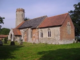
The parish church of Saint Peter and Saint Paul
The earliest parts of this church are SaxonAnglo-Saxon architecture
Anglo-Saxon architecture was a period in the history of architecture in England, and parts of Wales, from the mid-5th century until the Norman Conquest of 1066. Anglo-Saxon secular buildings in Britain were generally simple, constructed mainly using timber with thatch for roofing...
but over the years it has been added and altered by the Normans
Normans
The Normans were the people who gave their name to Normandy, a region in northern France. They were descended from Norse Viking conquerors of the territory and the native population of Frankish and Gallo-Roman stock...
, Tudors and in the 19th century by the Victorians. The nave
Nave
In Romanesque and Gothic Christian abbey, cathedral basilica and church architecture, the nave is the central approach to the high altar, the main body of the church. "Nave" was probably suggested by the keel shape of its vaulting...
reflect all these periods in its decoration. The north and south doorways date from the 14th century whilst the square headed windows date from the 15th century. There are fragments of mediaeval stain glass in the south window. Behind the pulpit there are the signs of a blocked of long demolished north Transept
Transept
For the periodical go to The Transept.A transept is a transverse section, of any building, which lies across the main body of the building. In Christian churches, a transept is an area set crosswise to the nave in a cruciform building in Romanesque and Gothic Christian church architecture...
. There is an octagonal font which dates from the 15th century. The pulpit is from the 17th century and is decorated with heads of angels. The pulpit was originally from the church at North Barningham
North Barningham
North Barningham is a Hamlet within the civil parish of Gresham in the English county of Norfolk. The Hamlet is miles south west of Cromer, miles north-northwest of Norwich and miles north-northeast of London. The Hamlet lies miles south of the town of Sheringham. The nearest railway station...
. The screen dates from the 14th century. The church has a round tower which is 48 feet tall and has a diameter of 7 feet. The walls are 3 ft 4ins thick. The lower part of this round tower is from the Saxon period. The higher reaches were built in the 14th and 15th century. The tower has a single bell which was cast between 1400 and 1425. The south porch of the church is late 14th century but has undergone restoration work in 1896.