
Sund, Norway
Encyclopedia
Sund is a municipality
in the county
of Hordaland
, Norway
. Sund covers the southern part of the island of Store Sotra
, west of Bergen
, and many smaller, surrounding islands. The history of the municipality dates back to 1838, when Sund was first established as a formannskapsdistrikt
, the precursor of the modern municipalities. Sund is a predominantly rural
municipality, with no major settlements, the largest being Klokkarvik
with approximately 630 inhabitants. Due to the proximity to Bergen
, a large proportion of the population commutes to the city to work, although fewer than in its neighbouring municipality, Fjell
.
on January 1, 1838. Austevoll
was separated from Sund on January 1, 1886. The municipality is named after the farm Sund, where the first church was built. The name is identical with the word "sund", which translates into English as "strait
". The coat-of-arms is from 1988, and shows a lighthouse
.
On April 26, 1942, after having discovered that two men from the Linge company were being hidden in Telavåg, the Gestapo
arrived to arrest the Norwegian officers. Shots were exchanged, and two prominent German Gestapo officers, Johannes Behrens and Henry Bertram, and the Norwegian Arne Værum, were shot dead. Reichskommissar
Josef Terboven
ordered the Gestapo to retaliate, burning all buildings in the village, executing or sending the men to the Sachsenhausen concentration camp
, and imprisoning the women and children for two years. In addition, 18 Norwegian prisoners at a Norwegian internment camp were killed as a reprisal. The event has since become known as the "Telavåg tragedy
", and is sometimes compared to similar World War II
atrocities, such as the Lidice
massacre, with higher death tolls.
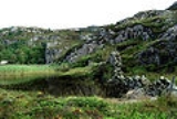
, as well as the many islands that surround it. The largest of the smaller islands are Toftarøy, Lerøy, Bjelkarøy, Tyssøy, Risøy, Vardøy, Golten, and Viksøy. In total, the municipality encompasses 466 islands and skerries, which gives it a total coastline of 110 km.
The highest peak is Førdesveten, at 284 metres above sea level.
The fjord separating Store-Sotra from the mainland, Krossfjorden
, is historically the most used sea route into Bergen, and is as much as 600 metres deep in some places. The treacherous waters in the area mean there has been a continuous need for piloting services, and this tradition is kept alive by the "Viksøy Losstasjon".
, within the border of the municipality. The largest is Klokkarvik
in south-eastern Sund, with 632 inhabitants as of 2008. The two others are Tælavåg and Hammersland, with 489 and 407 inhabitants, respectively. The municipal administration center, Skogsvåg
, is not defined as an urban settlement, having less than 200 inhabitants, but is located near Hammersland in the north.
, opened in 1971, drastically improved communications and spurred rapid population growth after ages of stagnance. Due to the rapidly increasing traffic across the bridge and on the highways of Sotra, the Norwegian Public Roads Administration
developed plans in the 2000s for a new bridge and highway between Bergen and Sotra. The plans include a new dual carriageway
bridge to replace the Sotra Bridge, and new highways that lead northwards to Øygarden
and southwards to Sund.
Municipalities of Norway
Norway is divided into 19 administrative regions, called counties , and 430 municipalities...
in the county
Counties of Norway
Norway is divided into 19 administrative regions, called counties . The counties form the primary first-level subdivisions of Norway and are further divided into 430 municipalities...
of Hordaland
Hordaland
is a county in Norway, bordering Sogn og Fjordane, Buskerud, Telemark and Rogaland. Hordaland is the third largest county after Akershus and Oslo by population. The county administration is located in Bergen...
, Norway
Norway
Norway , officially the Kingdom of Norway, is a Nordic unitary constitutional monarchy whose territory comprises the western portion of the Scandinavian Peninsula, Jan Mayen, and the Arctic archipelago of Svalbard and Bouvet Island. Norway has a total area of and a population of about 4.9 million...
. Sund covers the southern part of the island of Store Sotra
Sotra
Sotra is the name of an archipelago in Hordaland, Norway, just west of Bergen. The largest island is Store Sotra, while the second-largest and most populated is Litlesotra. The latter and part of Store Sotra are part of Fjell, while southern Sotra is part of Sund. Roughly 25,000 people live on Sotra...
, west of Bergen
Bergen
Bergen is the second largest city in Norway with a population of as of , . Bergen is the administrative centre of Hordaland county. Greater Bergen or Bergen Metropolitan Area as defined by Statistics Norway, has a population of as of , ....
, and many smaller, surrounding islands. The history of the municipality dates back to 1838, when Sund was first established as a formannskapsdistrikt
Formannskapsdistrikt
Formannskapsdistrikt was the name for a Norwegian local self-government districts put into force in 1838. This system of municipality was created in a bill approved by the Storting and signed into law by King Carl Johan on 14 January 1837...
, the precursor of the modern municipalities. Sund is a predominantly rural
Rural
Rural areas or the country or countryside are areas that are not urbanized, though when large areas are described, country towns and smaller cities will be included. They have a low population density, and typically much of the land is devoted to agriculture...
municipality, with no major settlements, the largest being Klokkarvik
Klokkarvik
Klokkarvik is a community in the municipality of Sund, Hordaland, Norway, located approximately 40 minutes outside the city of Bergen....
with approximately 630 inhabitants. Due to the proximity to Bergen
Bergen
Bergen is the second largest city in Norway with a population of as of , . Bergen is the administrative centre of Hordaland county. Greater Bergen or Bergen Metropolitan Area as defined by Statistics Norway, has a population of as of , ....
, a large proportion of the population commutes to the city to work, although fewer than in its neighbouring municipality, Fjell
Fjell
Fjell is a municipality in the county of Hordaland, Norway. The parish of Fjæld was established as a municipality on 1 January 1838...
.
History
Sund was established as a formannskapsdistriktFormannskapsdistrikt
Formannskapsdistrikt was the name for a Norwegian local self-government districts put into force in 1838. This system of municipality was created in a bill approved by the Storting and signed into law by King Carl Johan on 14 January 1837...
on January 1, 1838. Austevoll
Austevoll
Austevoll is a municipality and an archipelago in the district of Midthordland in the county of Hordaland in Western Norway, Norway. Austevoll was separated from Sund on 1 January 1886....
was separated from Sund on January 1, 1886. The municipality is named after the farm Sund, where the first church was built. The name is identical with the word "sund", which translates into English as "strait
Strait
A strait or straits is a narrow, typically navigable channel of water that connects two larger, navigable bodies of water. It most commonly refers to a channel of water that lies between two land masses, but it may also refer to a navigable channel through a body of water that is otherwise not...
". The coat-of-arms is from 1988, and shows a lighthouse
Lighthouse
A lighthouse is a tower, building, or other type of structure designed to emit light from a system of lamps and lenses or, in older times, from a fire, and used as an aid to navigation for maritime pilots at sea or on inland waterways....
.
On April 26, 1942, after having discovered that two men from the Linge company were being hidden in Telavåg, the Gestapo
Gestapo
The Gestapo was the official secret police of Nazi Germany. Beginning on 20 April 1934, it was under the administration of the SS leader Heinrich Himmler in his position as Chief of German Police...
arrived to arrest the Norwegian officers. Shots were exchanged, and two prominent German Gestapo officers, Johannes Behrens and Henry Bertram, and the Norwegian Arne Værum, were shot dead. Reichskommissar
Reichskommissar
Reichskommissar , in German history, was an official gubernatorial title used for various public offices during the period of the German Empire and the Nazi Third Reich....
Josef Terboven
Josef Terboven
Josef Antonius Heinrich Terboven was a Nazi leader, best known as the Reichskommissar during the German occupation of Norway.-Early life:...
ordered the Gestapo to retaliate, burning all buildings in the village, executing or sending the men to the Sachsenhausen concentration camp
Sachsenhausen concentration camp
Sachsenhausen or Sachsenhausen-Oranienburg was a Nazi concentration camp in Oranienburg, Germany, used primarily for political prisoners from 1936 to the end of the Third Reich in May, 1945. After World War II, when Oranienburg was in the Soviet Occupation Zone, the structure was used as an NKVD...
, and imprisoning the women and children for two years. In addition, 18 Norwegian prisoners at a Norwegian internment camp were killed as a reprisal. The event has since become known as the "Telavåg tragedy
Telavåg
Telavåg is a small village in the municipality of Sund, located 39 km south west of Bergen, Norway, with a population of about 600.-Telavåg tragedy:...
", and is sometimes compared to similar World War II
World War II
World War II, or the Second World War , was a global conflict lasting from 1939 to 1945, involving most of the world's nations—including all of the great powers—eventually forming two opposing military alliances: the Allies and the Axis...
atrocities, such as the Lidice
Lidice
Lidice is a village in the Czech Republic just northwest of Prague. It is built on the site of a previous village of the same name which, as part of the Nazi Protectorate of Bohemia and Moravia, was on orders from Reichsführer-SS Heinrich Himmler, completely destroyed by German forces in reprisal...
massacre, with higher death tolls.
Geography
Sund covers the southern part of the island of Store SotraSotra
Sotra is the name of an archipelago in Hordaland, Norway, just west of Bergen. The largest island is Store Sotra, while the second-largest and most populated is Litlesotra. The latter and part of Store Sotra are part of Fjell, while southern Sotra is part of Sund. Roughly 25,000 people live on Sotra...
, as well as the many islands that surround it. The largest of the smaller islands are Toftarøy, Lerøy, Bjelkarøy, Tyssøy, Risøy, Vardøy, Golten, and Viksøy. In total, the municipality encompasses 466 islands and skerries, which gives it a total coastline of 110 km.
The highest peak is Førdesveten, at 284 metres above sea level.
The fjord separating Store-Sotra from the mainland, Krossfjorden
Krossfjorden
Krossfjorden is a 30 km long fjord on the west coast of Spitsbergen, which is the largest and only permanently populated island of the Svalbard archipelago in Norway. To the north, the fjord branches into Lillehöökfjorden, Möllerfjorden and Kollerfjorden...
, is historically the most used sea route into Bergen, and is as much as 600 metres deep in some places. The treacherous waters in the area mean there has been a continuous need for piloting services, and this tradition is kept alive by the "Viksøy Losstasjon".
Climate
On an average, Sotra experiences 1328 mm of rainfall annually, less than the 2250 mm of Bergen. The year-round average temperature is 7.6 °C, with the coldest month being February, when the average temperature reaches 2.1 °C. The warmest month is August, with an average temperature of 12.8 °C.Settlements
There are three urban settlements, as defined by Statistics NorwayStatistics Norway
Statistics Norway is the Norwegian statistics bureau. It was established in 1876.Relying on a staff of about 1,000, Statistics Norway publish about 1,000 new statistical releases every year on its web site. All releases are published both in Norwegian and English...
, within the border of the municipality. The largest is Klokkarvik
Klokkarvik
Klokkarvik is a community in the municipality of Sund, Hordaland, Norway, located approximately 40 minutes outside the city of Bergen....
in south-eastern Sund, with 632 inhabitants as of 2008. The two others are Tælavåg and Hammersland, with 489 and 407 inhabitants, respectively. The municipal administration center, Skogsvåg
Skogsvåg
Skogsvåg is a rural community in the municipality of Sund, Norway. It is the administration centre of the municipality. Skogsvåg is located in northern Sund, near Hammarsland, a Statistics Norway-defined urban settlement....
, is not defined as an urban settlement, having less than 200 inhabitants, but is located near Hammersland in the north.
Transport
The Sotra BridgeSotra Bridge
The Sotra Bridge is a suspension bridge which crosses Knarreviksundet between Knarrevik in Fjell and Drotningsvik on the mainland of Bergen in Hordaland, Norway. It carries two road lanes and two narrow pedestrian paths of National Road 555, providing a fixed link for the archipelago of Sotra. The...
, opened in 1971, drastically improved communications and spurred rapid population growth after ages of stagnance. Due to the rapidly increasing traffic across the bridge and on the highways of Sotra, the Norwegian Public Roads Administration
Norwegian Public Roads Administration
The Norwegian Public Roads Administration is a Norwegian government agency responsible for the state and county public roads in the country. This includes planning, construction and operation of the state and county road networks, driver training and licensing, vehicle inspection and subsidies to...
developed plans in the 2000s for a new bridge and highway between Bergen and Sotra. The plans include a new dual carriageway
Dual carriageway
A dual carriageway is a class of highway with two carriageways for traffic travelling in opposite directions separated by a central reservation...
bridge to replace the Sotra Bridge, and new highways that lead northwards to Øygarden
Øygarden
Øygarden is a municipality in Hordaland county, Norway. It is located in the traditional district of Midhordland. The administrative centre is Rong.Øygarden was created as a new municipality on 1 January 1964 after the merger of Hjelme and parts of Herdla....
and southwards to Sund.