
Suffolk Coastal
Encyclopedia
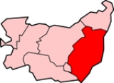
Suffolk Coastal is a local government district
in Suffolk
, England
. Its council is based in Woodbridge
. Other towns include Felixstowe
.
The district was formed on 1 April 1974, under the Local Government Act 1972
, as a merger of the municipal borough
of Aldeburgh
, along with Felixstowe, Leiston-cum-Sizewell, Saxmundham
and Woodbridge urban district
s, and Blyth Rural District and Deben Rural District
.
Non-metropolitan district
Non-metropolitan districts, or colloquially shire districts, are a type of local government district in England. As created, they are sub-divisions of non-metropolitan counties in a so-called "two-tier" arrangement...
in Suffolk
Suffolk
Suffolk is a non-metropolitan county of historic origin in East Anglia, England. It has borders with Norfolk to the north, Cambridgeshire to the west and Essex to the south. The North Sea lies to the east...
, England
England
England is a country that is part of the United Kingdom. It shares land borders with Scotland to the north and Wales to the west; the Irish Sea is to the north west, the Celtic Sea to the south west, with the North Sea to the east and the English Channel to the south separating it from continental...
. Its council is based in Woodbridge
Woodbridge, Suffolk
Woodbridge is a town in Suffolk, East Anglia, England. It is in the East of England, not far from the coast. It lies along the River Deben, with a population of about 7,480. The town is served by Woodbridge railway station on the Ipswich-Lowestoft East Suffolk Line. Woodbridge is twinned with...
. Other towns include Felixstowe
Felixstowe
Felixstowe is a seaside town on the North Sea coast of Suffolk, England. The town gives its name to the nearby Port of Felixstowe, which is the largest container port in the United Kingdom and is owned by Hutchinson Ports UK...
.
The district was formed on 1 April 1974, under the Local Government Act 1972
Local Government Act 1972
The Local Government Act 1972 is an Act of Parliament in the United Kingdom that reformed local government in England and Wales on 1 April 1974....
, as a merger of the municipal borough
Municipal borough
Municipal boroughs were a type of local government district which existed in England and Wales between 1835 and 1974, in Northern Ireland from 1840 to 1973 and in the Republic of Ireland from 1840 to 2002...
of Aldeburgh
Aldeburgh
Aldeburgh is a coastal town in Suffolk, East Anglia, England. Located on the River Alde, the town is notable for its Blue Flag shingle beach and fisherman huts where freshly caught fish are sold daily, and the Aldeburgh Yacht Club...
, along with Felixstowe, Leiston-cum-Sizewell, Saxmundham
Saxmundham
Saxmundham is a small market town in Suffolk, England. It is set in the valley of the River Fromus, a tributary of the River Alde, approximately northeast of Ipswich and west of the coast at Sizewell. The town is bypassed by the A12 and is served by Saxmundham railway station on the East Suffolk...
and Woodbridge urban district
Urban district
In the England, Wales and Ireland, an urban district was a type of local government district that covered an urbanised area. Urban districts had an elected Urban District Council , which shared local government responsibilities with a county council....
s, and Blyth Rural District and Deben Rural District
Deben Rural District
Deben Rural District was a rural district in the county of East Suffolk, England. It was created in 1934 by the merger of parts ofthe disbanded Bosemere and Claydon Rural District, the disbanded Plomesgate Rural District and the disbanded Woodbridge Rural District, under a County Review Order.It...
.
List of communities
There are 117 civil parishes and towns in Suffolk Coastal.- AldeburghAldeburghAldeburgh is a coastal town in Suffolk, East Anglia, England. Located on the River Alde, the town is notable for its Blue Flag shingle beach and fisherman huts where freshly caught fish are sold daily, and the Aldeburgh Yacht Club...
- AldertonAlderton, SuffolkAlderton is a village and civil parish in the Suffolk Coastal district of Suffolk, England, about six miles north of Felixstowe, 10 miles south-east of Woodbridge and 2 miles south of Hollesley, on the North Sea coast and in the heart of Heaths of Outstanding Natural Beauty. In 2007 its population...
- Aldringham cum ThorpeAldringham cum ThorpeAldringham cum Thorpe is a civil parish in the Suffolk Coastal district of Suffolk, England. Located south of the town of Leiston, the parish includes the villages of Aldringham and Thorpeness, which is on the coast, between Sizewell and Aldeburgh . In 2007 it had an estimated population of 700....
- BadinghamBadinghamBadingham is a village and civil parish in the Suffolk Coastal district of Suffolk in eastern England. In 2007 it had an estimated population of 470....
- BawdseyBawdseyBawdsey is a village and civil parish in Suffolk, eastern England. Located near Felixstowe, it had an estimated population of 340 in 2007.Bawdsey Manor is notable as the place where radar research took place early in World War II, before moving to Worth Matravers, which is four miles to the west of...
- BenhallBenhallBenhall is a village and civil parish in the Suffolk Coastal district of Suffolk, England. Located to the south of Saxmundham, in 2007 its population was estimated to be 560....
- BlaxhallBlaxhallBlaxhall is a village and civil parish in the Suffolk Coastal district of Suffolk, England.Located around west of Aldeburgh, in 2007 its population was estimated to be 220.-External links:*...
- BlythburghBlythburghBlythburgh is a small English village in an area known as the Sandlings, part of the Suffolk heritage coast. Located close to an area of flooded marshland and mud-flats, in 2007 its population was estimated to be 300. Blythburgh is best known for its church, Holy Trinity, internationally known as...
- BoulgeBoulgeBoulge is a hamlet and civil parish in the Suffolk Coastal district of Suffolk, England. It is about north of Woodbridge.Boulge church is the burial place of famous local poet/writer Edward Fitzgerald, whose most famous work was the translation The Rubaiyat of Omar Khayyam.-External links:*...
- BoytonBoyton, SuffolkBoyton is a village and civil parish in the Suffolk Coastal district of Suffolk, England, about eight miles east of Woodbridge, and close to Orford Ness....
- BramfieldBramfield, SuffolkBramfield is a small village in the county of Suffolk, England. The village is found off the A12 road, one of the main arterial routes through the county....
- BrandestonBrandestonBrandeston is a village in Suffolk, England on the River Deben. 'Brandeston Hall'the largest building in the village, is now the preparatory department of nearby Framlingham College...
- BredfieldBredfieldBredfield is a small village and civil parish in the English county of Suffolk. It is situated just off the A12, two miles north of Woodbridge. Another village, Dallinghoo, is to the north, and to the west is Boulge, a small hamlet...
- BrightwellBrightwell, SuffolkBrightwell is a village and a civil parish in the Suffolk Coastal District, in the English county of Suffolk. It has a place of worship. For transport there is the A12 road nearby. It is near the large town of Ipswich. Adjacent parishes include Foxhall, Bucklesham, Martlesham and Newbourne.John...
- BromeswellBromeswellBromeswell is a village and civil parish in the Suffolk Coastal district of Suffolk, England about 2 miles east of Woodbridge.Bromeswell shows many of the characteristics of a traditional English village. It is one of the most secluded, beautiful spots in Suffolk...
- BruisyardBruisyardBruisyard is a village in the valley of the River Alde in the county of Suffolk, England. The village has a population of ~175. The village sign depicts Saint Clare of the Order of the Poor Clares who had an abbey in Bruisyard until the dissolution of the monasteries under Henry VIII...
- BuckleshamBuckleshamBucklesham is a village and civil parish in the Suffolk Coastal district of Suffolk, England, a few miles east of Ipswich.The village pub is The Shannon, named after Admiral Brooke's ship....
- BurghBurgh, SuffolkBurgh is a village and civil parish in the Suffolk Coastal district of Suffolk, England, about north-west of Woodbridge.St. Boltoph's church stands near the site of a Roman villa that stretches towards Clopton churchyard...
- ButleyButley, SuffolkButley is a village and civil parish in the English county of Suffolk.Butley lies east of the town of Woodbridge on the B1084 road. Administratively, Butley forms part of the Suffolk Coastal district; from 1934 to 1974 it had been part of the former Deben Rural District.- External links :**...
- Campsea AsheCampsea AsheCampsea Ashe is a village in Suffolk, England located approximately north east of Woodbridge and south west of Saxmundham.The village is served by Wickham Market railway station on the Ipswich-Lowestoft East Suffolk Line....
- Capel St AndrewCapel St AndrewCapel St Andrew is a village and a civil parish in the Suffolk Coastal district, in the county of Suffolk, England. It is near the larger settlement of Orford.Capel St Andrew is close to the River Butley which is a tributary to the River Ore...
- CharsfieldCharsfieldCharsfield is a small Suffolk village of approximately 250 residents, from Wickham Market, miles from Woodbridge and miles from Ipswich and is located near the villages of Debach and Dallinghoo...
- ChedistonChedistonChediston is a village and a civil parish on the B1123 road, in the Suffolk Coastal District, in the English county of Suffolk. It is 2 miles W. of Halesworth, its post town. Chediston has a church...
- ChillesfordChillesfordChillesford is a village and a civil parish in the Suffolk Coastal District, in the English county of Suffolk. It is located on the B1084 road Hertfords Place, which runs east to west....
- CloptonClopton, SuffolkClopton is a village in Suffolk. It is located between Ipswich and Debenham two kilometres north of Grundisburgh on the River Lark. A road with houses on each side is the extent of the village, surrounded by farm land....
- CookleyCookley, SuffolkCookley is a village and a civil parish in the Suffolk Coastal district, in the county of Suffolk, England. Nearby settlements include the town of Halesworth and the village of Walpole. It has a church called Church of St Michael.- External links :*...
- CransfordCransfordCransford is a village and a civil parish in the Suffolk Coastal District, in the English county of Suffolk. It is near the small town of Framlingham. Cransford has 2 places of worship.- References :* http://www.ukvillages.co.uk/Place/6725/Cransford-Suffolk...
- CratfieldCratfieldCratfield is a village in northern Suffolk, England.Neighbouring villages include Laxfield, Metfield, Cookley, Huntingfield, Heveningham. The nearest town, Halesworth, is approximately 5 miles away. Southwold is a popular, nearby coastal town. The market town of Framlingham is also close...
- CretinghamCretinghamCretingham is a village and a civil parish in the Suffolk Coastal District, in the English county of Suffolk. It is on the River Deben, 2 miles south off the A1120 road...
- CulphoCulphoCulpho is a hamlet of about 40 people standing just outside Grundisburgh, Suffolk, about four miles west of Woodbridge. Its nearest villages are Great Bealings and Playford...
- DallinghooDallinghoo- Location :Dallinghoo is a village some 3 miles north of Woodbridge, Suffolk, England.Formed from Church Road and Pound Hill to the south and branches NE after the centre of the village....
- DarshamDarshamDarsham is a village in Suffolk, England. It is located approximately north east of Saxmundham. The village is bypassed by the A12 and is served by Darsham railway station, which is approximately one mile away from the village centre, on the Ipswich-Lowestoft East Suffolk Line.The name of the...
- DebachDebachDebach is a small village about 4 miles northwest of Woodbridge, Suffolk, UK. At the time of the Domesday Book it was called Debenbeis or Debeis, Depebecs, Debec or Debes...
- DenningtonDenningtonFor the town in Victoria, Australia, see Dennington, VictoriaDennington is a small village in Suffolk, England, just north of Framlingham along the A1120 Bypass.-External links:* - village's local newspaper website...
- DunwichDunwichDunwich is a small town in Suffolk, England, within the Suffolk Coast and Heaths AONB.Dunwich was the capital of East Anglia 1500 years ago but the harbour and most of the town have since disappeared due to coastal erosion. Its decline began in 1286 when a sea surge hit the East Anglian coast, and...
- Earl SohamEarl SohamEarl Soham is a small settlement in Suffolk, England. It is on the A1120 road and is west of the town of Framlingham.- History :The manor of Earl Soham once belonged to the Earls of Norfolk, the Bigod family , who also owned nearby Framlingham Castle.Edward 1st granted Roger Bigod permission to...
- EastonEaston, SuffolkThe former estate village of Easton in England is situated on the River Deben around three miles south of Framlingham. Following the end of the World War 1 the British government imposed super taxes on the rich to help defray the cost of the war...
- EykeEykeEyke is a village and a civil parish in the Suffolk Coastal District, in the English county of Suffolk. It is located on the A1152 road near the town of Woodbridge. Eyke has a primary school, a place of worship and a pub.- References :...
- FalkenhamFalkenhamFalkenham is a village and a civil parish in the Suffolk Coastal District, in the English county of Suffolk. It is located near the village of Kirton and the towns of Ipswich and Felixtowe. The parish contains the hamlets of Falkenham Sink and Lower Falkenham. The village has a church called St...
- FarnhamFarnham, SuffolkFarnham is a village and civil parish about 4 km South-South West of Saxmundham in Suffolk, England on the A12. Its history goes back to at least 1707 C.E....
- FelixstoweFelixstoweFelixstowe is a seaside town on the North Sea coast of Suffolk, England. The town gives its name to the nearby Port of Felixstowe, which is the largest container port in the United Kingdom and is owned by Hutchinson Ports UK...
- FoxhallFoxhall, SuffolkFoxhall is a civil parish in the Suffolk Coastal district of Suffolk, England, a few miles east of Ipswich. It is adjacent to the parishes of Kesgrave to the north, Martlesham to the north east, Brightwell to the east, Purdis Heath to the south and the borough of Ipswich to the west. The three...
- FramlinghamFramlinghamFramlingham is a market town and civil parish in the Suffolk Coastal District of Suffolk, England. Commonly referred to as "Fram" by the locals, it is of Anglo-Saxon origin and is mentioned in the Domesday Book. It has a population of 3,114 at the 2001 census...
- FristonFristonFriston is a village in Suffolk, England. It is southeast of Saxmundham, its post town, and northwest of Aldeburgh. The River Alde bounds the village on the south. The surrounding land is chiefly arable. The soil becomes partly marshy in the lower grounds...
- GedgraveGedgraveGedgrave is a small village and civil parish in the Suffolk Coastal district of Suffolk in eastern England. In 2005 its population was 30. It shares a parish council with nearby Orford.-External links:*...
- Great BealingsGreat BealingsGreat Bealings is a small village in Suffolk, England. It has about 310 people living in it, in around 120 households. Its nearest towns are Ipswich and Woodbridge . Nearby villages include Little Bealings, Playford, Culpho, Hasketon and Grundisburgh...
- Great GlemhamGreat GlemhamGreat Glemham is a village and a civil parish in the Suffolk Coastal District, in the English county of Suffolk. It is a few miles away from the A12 road. Great Glemham has a pub and two places of worship. It is located between the towns of Framlingham and Saxmundham.- References :*...
- GrundisburghGrundisburghGrundisburgh is a village of more than 1,530 residents situated in the English county of Suffolk. It is in the Suffolk Coastal district, six miles north-east from Ipswich and four miles north-west of Woodbridge located on the B1079. Flowing through the village are the rivers Lark and Gull...
- HachestonHachestonHacheston is a village and a civil parish in the Suffolk Coastal District, in the English county of Suffolk. It is located on the B1116 road between the towns of Wickham Market and Framlingham. Hacheston has a church and a village hall; it once had a railway station called Hacheston Halt railway...
- HasketonHasketonHasketon is a small village in Suffolk, England.Its church, St. Andrews, is one of 38 existing round-tower churches in Suffolk. St. Andrews stands more or less at the centre of its scattered parish, and is set in a tree-shaded churchyard which, in 1845, had been planted with beech, fir and...
- HemleyHemleyHemley is a village and a civil parish in the Suffolk Coastal District, in the English county of Suffolk. It is located near the River Deben. Nearby settlements include the large town of Ipswich and the villages of Waldringfield and Newbourne. Hemley has a place of worship...
- HeveninghamHeveninghamHeveningham is a village and civil parish in the Suffolk Coastal district of Suffolk in eastern England. Located four miles south-west of Halesworth, in 2005 it had a population of 120....
- HollesleyHollesleyHollesley is a village and civil parish in the Suffolk Coastal district of Suffolk in eastern England. Located on the Bawdsey peninsula five miles south-east of Woodbridge, in 2005 it had a population of 1,400.Hollesley Bay Prison is located nearby....
- HooHoo, SuffolkHoo is a village and a civil parish in the Suffolk Coastal district, in the county of Suffolk, England. Nearby settlements include the town of Wickham Market and the villages of Kettleburgh, Charsfield and Letheringham.- References :...
- HuntingfieldHuntingfield, SuffolkHuntingfield is a village near the B1117 road, in the Suffolk Coastal district, in the county of Suffolk, England close to the source of the river Blyth. Nearby settlements include the town of Halesworth and the villages of Walpole, Heveningham and Cookley....
- IkenIkenIken is a small village and civil parish in the marshlands of the English county of Suffolk.It is near the estuary of the River Alde on the North Sea coast and is located south east of Snape and due north of Orford....
- Kelsale cum CarltonKelsale cum CarltonSituated to the north of Saxmundham, Kelsale cum Carlton is really two or more adjoining villages or hamlets such as the curiously named Dorley's Corner and Curlew Green, plus East Green and North Green falling within its boundaries...
- KesgraveKesgraveKesgrave is a small town in the English county of Suffolk on the northern edge of Ipswich.-Early history:The town was recorded as Gressgrava in the Domesday Book, by the late 15th century its name had become Kesgrave...
- KettleburghKettleburghKettleburgh is a small village in the Suffolk Coastal district, in the county of Suffolk. Kettleburgh has a church called St Andrews church and a pub. It is near the small towns of Wickham Market and Framlingham.- References :* *...
- KirtonKirton, SuffolkKirton is a village and a civil parish in Suffolk, England, situated off the A14 road, close to Felixstowe....
- KnodishallKnodishallKnodishall is a village in Suffolk, England. The village is located southeast of Saxmundham and southwest of Leiston, its post town. Most of the village is now in Coldfair Green, with only a few houses remaining in the original village by the parish church of St Lawrence.-Community:The village...
- LeistonLeistonLeiston is a town in eastern Suffolk, England. It is situated near Saxmundham and Aldeburgh, about from the North Sea coast and is northeast of Ipswich and northeast from London...
- LetheringhamLetheringhamLetheringham is a sparsely populated civil parish in the Suffolk Coastal in Suffolk, England, on the Deben River.-Sights:St Mary is a tiny church, the remains of the tower and nave of a Priory church, and sits in a farmyard...
- LevingtonLevingtonLevington is a small village in the Suffolk Coastal District, in the county of Suffolk. Levington has a church called St Peters Church and a pub. It is near the large town of Ipswich and the village of Nacton. A viking ship was once found in Levington....
- Linstead MagnaLinstead MagnaLinstead Magna is a civil parish in the Suffolk Coastal district of Suffolk in eastern England. In 2005 its population was 60. It shares a parish council with nearby Chediston and Linstead Parva.-External links:*...
- Linstead ParvaLinstead ParvaLinstead Parva is a small village and civil parish in the Suffolk Coastal district of Suffolk in eastern England. In 2005 its population was 90, making it larger than neighbouring Linstead Magna. It shares a parish council with Linstead Magna and nearby Chediston.-External links:*...
- Little BealingsLittle BealingsLittle Bealings is a village in Suffolk, England. It has a population of approximately 470 people living in around 185 households. Its nearest towns are Ipswich and Woodbridge...
- Little GlemhamLittle GlemhamLittle Glemham is a small village on the A12 road , in the Suffolk Coastal District, in the county of Suffolk. Nearby settlements include the town of Wickham Market and the village of Marlesford. Little Glemham has a church called St Andrew Church, a pub and a hall called Glemham Hall. The...
- MarlesfordMarlesfordMarlesford is a village and a civil parish in the Suffolk Coastal District, in the English county of Suffolk.- Location :It is about 2 miles away from the small town of Wickham Market. Marlesford has a place of worship and a pub. The area of the village that is on the A12 road is due to be...
- MartleshamMartleshamMartlesham is a village in Suffolk, England about two miles South-West of Woodbridge and East of Ipswich. It is often referred to as "old Martlesham" by locals in order to distinguish this old village from the much more recent Martlesham Heath development to the south although both form a...
- MeltonMelton, SuffolkMelton is a village in Suffolk, England, located approximately one mile north east of Woodbridge. The 2001 census recorded a population of 3718. The village is served by Melton railway station on the Ipswich-Lowestoft East Suffolk Line....
- MiddletonMiddleton, SuffolkMiddleton is a village in Suffolk, England. It is located approximately north-west of Leiston, north east of Saxmundham and from the Suffolk coast. The village is on the B1122 east of Yoxford and had a population of 359 at the 2001 census....
- MonewdenMonewdenMonewden is a small village and a civil parish in the in the hundred of Loss, in the Suffolk Coastal District, in the English county of Suffolk. Monewden has a church called St. Mary's Church and a meadow called High House Meadows. The nearest town is Wickham Market.- References :*...
- NactonNactonNacton is a civil parish in the Suffolk Coastal region of Suffolk, England, taking its name from the village within it. The parish is bounded by the neighbouring parishes of Levington to the east and Bucklesham in the north. It is located between the towns of Ipswich and Felixstowe.Nacton abuts...
- NewbourneNewbourneNewbourne is a village and civil parish in the Suffolk Coastal region of Suffolk, England. It lies on the peninsula between the River Orwell and the River Deben, to the east of Ipswich and south of Woodbridge.- Etymology :...
- OrfordOrford, SuffolkOrford is a small town in Suffolk, England, within the Suffolk Coast and Heaths AONB.Like many Suffolk coastal towns it was of some importance as a port and fishing village in the Middle Ages. It still has a fine mediaeval castle, built to dominate the River Ore.The main geographical feature of the...
- OtleyOtley, SuffolkOtley is a village located in the county of Suffolk, England, about eight miles north of Ipswich. The village is home to Otley Hall, a 16th century, Grade I listed house which was historically the seat of the family of Bartholomew Gosnold, and Otley College, offering vocationally focused courses...
- ParhamParham-Places:in Antigua and Barbuda*Parham, Antigua and Barbuda, that claims to be the oldest town on Antigua*The Parham Peninsulain Canada*Parham, Ontarioin England*Parham Airfield Museum*Parham Park the area surrounding Parham House in West Sussex...
- PeasenhallPeasenhallPeasenhall is a village and a civil parish in the Suffolk Coastal District, in the English county of Suffolk. It was the location of the Peasenhall Murder.- Amenities :...
- PettistreePettistreePettistree is a village and a civil parish in the Suffolk Coastal District, in the English county of Suffolk. Pettistree has a place of worship and 2 pubs. It is just south of the small town of Wickham Market. For transport there is the A12 road nearby....
- PlayfordPlayford, SuffolkPlayford is a small village in Suffolk, England, on the outskirts of Ipswich. It has about 220 residents in 90 households. The River Fynn runs through the village, and many footpaths from Playford lead into the Fynn Valley. Villages nearby include Rushmere, Little Bealings, Great Bealings, Culpho...
- Purdis FarmPurdis FarmPurdis Farm is a small area of Ipswich and a civil parish, in the Suffolk Coastal District, in the English county of Suffolk.- References :* Suffolk A-Z...
- RamsholtRamsholtRamsholt is a small village in Suffolk, England. It is situated on the northern shore of the River Deben.Its church, All Saints, is one of 38 existing round-tower churches in Suffolk.It's economy revolves around the pub next to the river dock....
- RendhamRendhamRendham is a village and a civil parish on the B1119 road, in the Suffolk Coastal District, in the English county of Suffolk. It is near the small town of Saxmundham and the village of Sweffling. Rendham has a pub and a place of worship.-References:...
- Rendlesham
- Rushmere St Andrew
- SaxmundhamSaxmundhamSaxmundham is a small market town in Suffolk, England. It is set in the valley of the River Fromus, a tributary of the River Alde, approximately northeast of Ipswich and west of the coast at Sizewell. The town is bypassed by the A12 and is served by Saxmundham railway station on the East Suffolk...
- SaxteadSaxteadSaxtead is a small village in the Suffolk Coastal District, in the county of Suffolk. Saxtead gives its name to the settlements of Saxtead Green and Saxtead Little Green and the windmill Saxtead Green Windmill. Saxtead is located on the A1120 road in between the town of Stowmarket and the village...
- ShottishamShottishamShottisham is a village and civil parish in the Suffolk Coastal District, in the English county of Suffolk. The village is near the B1083 road. Shottisham has a place of worship, Saint Margaret's Church, a pub and a camp site...
- SibtonSibtonSibton is a village and a civil parish on the A1120 road, in the Suffolk Coastal District, in the English county of Suffolk. It is near the towns of Saxmundham and Halesworth, the village of Peasenhall and the hamlet of Sibton Green...
- SnapeSnape, SuffolkSnape is a small village in the English county of Suffolk, on the River Alde close to Aldeburgh. It has about 600 inhabitants. Snape is now best known for Snape Maltings, no longer in commercial use, but converted into a tourist centre together with a concert hall that hosts the major part of the...
- SternfieldSternfieldSternfield is a village in Suffolk, England. It is located south of Saxmundham, its post town. The village is very small and irregularly built, and is wholly agricultural. The village contains a church dedicated to St. Mary Magdalene....
- Stratford St AndrewStratford St AndrewStratford St Andrew is a village and a civil parish on the A12 road, in the Suffolk Coastal District, in the English county of Suffolk.-Location grid:...
- Stratton HallStratton HallStratton Hall is a civil parish in the Suffolk Coastal district of Suffolk in eastern England. In 2005 its population was 30. It shares a parish council with nearby Levington.-External links:*...
- SudbourneSudbourneSudbourne is a village and civil parish in Suffolk, England, located approximately north of Orford.Sudbourne is recognisable for Captain's Wood, a nature reserve owned by Suffolk Wildlife Trust and Crag Farm Pit which is listed as a Site of Special Scientific Interest in Suffolk. Sudbourne is also...
- SuttonSutton, SuffolkSutton is a village and a civil parish on the B1083 road, in the Suffolk Coastal district, in the county of Suffolk, England. Sutton has a pub, a post office and a place of worship. There is also the hamlet of Sutton Street and the Sutton Common estate nearby....
- SweflingSweflingSwefling is a village and a civil parish in the Suffolk Coastal district, in the county of Suffolk, England. Nearby settlements include the town of Saxmundham and the village of Rendham....
- SwillandSwillandSwilland is a village and a civil parish in the ancient hundred of Bosmere-and-Claydon, in the Suffolk Coastal District, in the English county of Suffolk. It is north of the large town of Ipswich. Swilland has a church called St Mary...
- ThebertonThebertonTheberton is a village in Suffolk, England. It is located northeast of Saxmundham, its post town. Located within the village is a National school for both sexes and Theberton Hall...
- ThoringtonThoringtonThorington is a village and a civil parish in the in the hundred of Blything, in the Suffolk Coastal District, in the English county of Suffolk. For transport there is the A12 road nearby. Nearby settlements include the town of Halesworth and the villages of Wenhaston and Blackheath...
- Trimley St Martin
- Trimley St Mary
- Tuddenham St Martin
- TunstallTunstall, SuffolkOn an Ordnance Survey map of Suffolk, England, there are two settlements named Tunstall next to each other, north east of Woodbridge. However, these are not two separate villages but one, despite the gap between the main village and the hamlet known as Tunstall Common...
- UbbestonUbbestonUbbeston is a village and a civil parish in the Suffolk Coastal district, in the county of Suffolk, England. Nearby settlements include the town of Halesworth, the village of Heveningham and the hamlet of Ubbeston Green....
- UffordUfford, SuffolkUfford is a village and civil parish in Suffolk, England. At the time of the 2001 census, the parish's population was 808 people.-External links:*...
- WalberswickWalberswickWalberswick is a village on the Suffolk coast in England, across the River Blyth from Southwold. Coastal erosion and the shifting of the mouth of the River Blyth meant that the neighbouring town of Dunwich was lost as a port in the last years of the 13th century...
- WaldringfieldWaldringfieldWaldringfield is a village and civil parish in the Suffolk Coastal district, in the county of Suffolk, England. It is situated on the bank of the River Deben within the Suffolk Coast and Heaths Area of Outstanding Natural Beauty, four miles south of the town of Woodbridge and eight miles east of...
- WalpoleWalpole, SuffolkWalpole is a village and a parish in Suffolk, England. Walpole has a chapel called Walpole Old Chapel and a primary school called Cookley and Walpole CEVC Primary School. The village is on the River Blyth. Nearby settlements include the town of Halesworth and the village of Cookley. It is in the...
- WantisdenWantisdenWantisden is a small village and civil parish in the Suffolk Coastal district of Suffolk in eastern England. Largely consisting of a single farm and ancient woodland , most of its 30 residents live on the farm estate. It shares a parish council with nearby Levington.-External links:*...
- Wenhaston with Mells HamletWenhaston with Mells HamletWenhaston with Mells Hamlet is a civil parish in the English county of Suffolk. It forms part of Suffolk Coastal district....
- WesterfieldWesterfieldWesterfield is a village in Suffolk, England.It is located approximately two miles north of the centre of Ipswich. The village is served by Westerfield railway station on the Ipswich-Lowestoft East Suffolk Line....
- WestletonWestletonWestleton is a village in the English county of Suffolk. It is located north of Leiston and miles north-east of Saxmundham near the North Sea coast. The village is on the edge of the Suffolk Sandlings, an area of lowland heathland...
- Wickham MarketWickham MarketWickham Market is a large village situated in the River Deben valley of Suffolk, England, within the Suffolk Coastal heritage area.It is on the A12 trunk road thirteen miles north-east of the county town of Ipswich, five miles north-east of Woodbridge. Its railway station is located approximately...
- WitneshamWitneshamWitnesham is a village situated roughly to the north of Ipswich, Suffolk. The main road from Ipswich that links the village to the town is the B1077, Westerfield Road....
- WoodbridgeWoodbridge, SuffolkWoodbridge is a town in Suffolk, East Anglia, England. It is in the East of England, not far from the coast. It lies along the River Deben, with a population of about 7,480. The town is served by Woodbridge railway station on the Ipswich-Lowestoft East Suffolk Line. Woodbridge is twinned with...
- YoxfordYoxfordYoxford is a village in the east of Suffolk, England close to the Heritage Coast, Minsmere Reserve , Aldeburgh and Southwold.-Location and features:...