

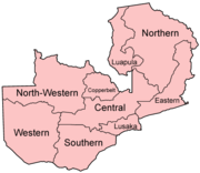
Subdivisions of Zambia
Encyclopedia
Zambia
Zambia , officially the Republic of Zambia, is a landlocked country in Southern Africa. The neighbouring countries are the Democratic Republic of the Congo to the north, Tanzania to the north-east, Malawi to the east, Mozambique, Zimbabwe, Botswana and Namibia to the south, and Angola to the west....
is divided into nine province
Province
A province is a territorial unit, almost always an administrative division, within a country or state.-Etymology:The English word "province" is attested since about 1330 and derives from the 13th-century Old French "province," which itself comes from the Latin word "provincia," which referred to...
s, each administered by an appointed deputy minister. Each province is divided into several district
District
Districts are a type of administrative division, in some countries managed by a local government. They vary greatly in size, spanning entire regions or counties, several municipalities, or subdivisions of municipalities.-Austria:...
s with a grand total of 72 districts. The provinces are:
- CentralCentral Province, ZambiaCentral Province is one of Zambia's nine provinces. The provincial capital is Kabwe, home of the Mulungushi Rock of Authority, founder home of UNIP, the ruling political party in the second republic ....
- CopperbeltCopperbelt ProvinceCopperbelt Province in Zambia covers the mineral-rich Copperbelt, and farming and bush areas to the south. It was the backbone of the Northern Rhodesian economy during British colonial rule and fuelled the hopes of the immediate post-independence period, but its economic importance was severely...
- EasternEastern Province, ZambiaEastern Province is one of Zambia's nine provinces. The province lies between the Luangwa River and the border with Malawi, from Isoka in the northeast to just north of Luangwa in the south.The provincial capital is Chipata...
- LuapulaLuapula ProvinceLuapula Province is one of Zambia's nine provinces, and is located in the north of the country. The provincial capital is Mansa. Luapula Province was named after the Luapula River....
- LusakaLusaka ProvinceLusaka Province is one of Zambia's nine provinces. The provincial capital is Lusaka, which is also the national capital.-National Parks and wildlife areas:*Lower Zambezi National Park...
- NorthernNorthern Province, ZambiaNorthern Province is one of Zambia's nine provinces. It covers approximately one fifth of Zambia in land area. The provincial capital is Kasama. The province is made up of 12 districts, namely Kasama , Chilubi, Isoka, Chinsali, Kaputa, Luwingu, Mbala, Mporokoso, Mpika, Mpulungu, Mungwi and Nakonde...
- North-WesternNorth-Western Province, ZambiaNorth-Western Province is one of Zambia's nine provinces. It covers an area of 125,826 km² and has a population of 583,350 . It is the most sparsely populated province in the country...
- SouthernSouthern Province, ZambiaSouthern Province is one of Zambia's nine provinces, and home to Zambia's premier tourist attraction, Mosi-oa-Tunya , shared with Zimbabwe...
- WesternWestern Province, ZambiaWestern Province, encompasses the area formerly known as Barotseland in the colonial era.-Districts:Western Province is divided into 7 districts:*Kalabo District*Kaoma District*Lukulu District*Mongu District*Senanga District*Sesheke District...