
Stony Kill Falls
Encyclopedia
Delaware Aqueduct
The Delaware Aqueduct is the newest of the New York City aqueducts. It takes water from the Rondout Reservoir through the Chelsea Pump Station, the West Branch Reservoir, and the Kensico Reservoir, ending at the Hillview Reservoir in Yonkers, New York....
. It is located in the town of Wawarsing
Wawarsing, New York
Wawarsing is a town in Ulster County, New York, United States. The population was 13,157 at the 2010 census. The name means "a place where the stream bends" in the Warwarsink language and refers to the geography of the land; particularly the joining of the Ver Nooy Kill and the Rondout Creek. The...
, on the northwestern edge of the Minnewaska Preserve on land recently acquired by the State of New York
New York
New York is a state in the Northeastern region of the United States. It is the nation's third most populous state. New York is bordered by New Jersey and Pennsylvania to the south, and by Connecticut, Massachusetts and Vermont to the east...
and The Open Space Institute
Open Space Institute
Open Space Institute is a conservation organization and think tank with an extensive mission statement. It seeks to preserve scenic, natural and historic landscapes for public enjoyment, conserve habitats while sustaining community character, and help protect the environment...
from Napanoch Sand and Gravel Company that once owned the land. Long a little know back entrance into the Minnewaska Preserve, utilized by curiosity seekers and more experienced mountaineers
Mountaineering
Mountaineering or mountain climbing is the sport, hobby or profession of hiking, skiing, and climbing mountains. While mountaineering began as attempts to reach the highest point of unclimbed mountains it has branched into specialisations that address different aspects of the mountain and consists...
, as a more convenient access point to Stony Kill
Kill (body of water)
As a body of water, a kill is a creek. The word comes from the Middle Dutch kille, meaning "riverbed" or "water channel." The modern Dutch term is kil....
Falls and the accompanying creek and carriage road.
Hiking guide
From the parking area walk East along a gravel woods road into an open clearing. On the left and right views begin to open. Steep cliffs are visible on the left and right as you continue further along the path. The higher section of the clearing features the fenced in shaft, a deep water valve, running hundreds of feet below the earth to the Catskill Aqueduct, one of the major sources of water for New York City. On the right is an aging helipadHelipad
Helipad is a common abbreviation for helicopter landing pad, a landing area for helicopters. While helicopters are able to operate on a variety of relatively flat surfaces, a fabricated helipad provides a clearly marked hard surface away from obstacles where a helicopter can safely...
, possible utilized as a quick access point for repairs to the Aqueduct. Continuing along the woods road the path dips down into an expansive gravel pit
Gravel pit
Gravel pit is the term for an open cast working for extraction of gravel. Gravel pits often lie in river valleys where the water table is high, so they may fill naturally with water to form ponds or lakes. Old, abandoned gravel pits are normally used either as nature reserves, or as amenity areas...
. Care is needed in this area as the shale is loose and sure footing is not guaranteed. Cast iron bars and solid chunks of limestone
Limestone
Limestone is a sedimentary rock composed largely of the minerals calcite and aragonite, which are different crystal forms of calcium carbonate . Many limestones are composed from skeletal fragments of marine organisms such as coral or foraminifera....
, shale
Shale
Shale is a fine-grained, clastic sedimentary rock composed of mud that is a mix of flakes of clay minerals and tiny fragments of other minerals, especially quartz and calcite. The ratio of clay to other minerals is variable. Shale is characterized by breaks along thin laminae or parallel layering...
, and granite
Granite
Granite is a common and widely occurring type of intrusive, felsic, igneous rock. Granite usually has a medium- to coarse-grained texture. Occasionally some individual crystals are larger than the groundmass, in which case the texture is known as porphyritic. A granitic rock with a porphyritic...
litter the area. There are steep embankments all along the left side of the gravel pit. Closer inspection of the gaps in the embankment find a view nearly 60 feet down to the bed of the Stony Kill Creek. Use caution as the embankment becomes very thin and should not be walked upon, especially in wet weather as it is slowly falling into the Stony Kill and the gravel pit.
Following the road Southwest, it slowly rises out of the gravel pit and re-enters the woods at the far end of the field. Views become temporarily obscured as the path approaches Stony Kill Falls. The path drops down to cross Stony Kill Creek. Following the spring melt the creek may run high making the path impassable. Views of the falls begin to open up as the trail splits, one leading the base of the falls and another leading to the plateau above the falls.
Above the falls
Dam
A dam is a barrier that impounds water or underground streams. Dams generally serve the primary purpose of retaining water, while other structures such as floodgates or levees are used to manage or prevent water flow into specific land regions. Hydropower and pumped-storage hydroelectricity are...
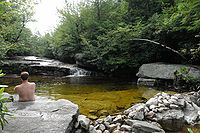
creating a pool above the cascade. This pool is known as Nudist Pool as it is tradition to bathe nude in the clean spring waters of the pool. Beyond the pool the river can be followed upward for several miles, where the hiker will come across many pools and small cascades as the river winds up the hill.
Technical information
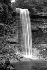
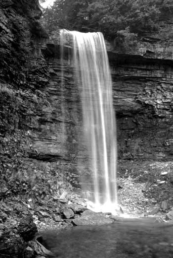
Stony Kill Falls is 87 feet high and one of the highest in the Minnewaska Preserve. Leaving the base of the falls and returning to the main trail the path ascends the side of the valley slowly gaining elevation. As it nears the top there is a 30-foot cascade near the side of the trail. Linking up with the Stony Kill Carriage Way at 1550 feet, the trail angles due west to the top of Stony Kill Falls. Views are expansive from the top of the falls, looking East, one can view the Stony Creek and Roundout Valleys. On a clear day there are views as far as Sullivan County. From the Carriage Way most of Minnewaska's trails are accessible.
- Use caution when exploring this area. Ice on the falls, especially the top is common throughout the fall, winter, and into late spring.
- There are no facilities here including bathrooms and trash service. Please carry out what you carry in, practice leave no traceLeave No TraceLeave No Trace is both a set of principles, and an organization that promotes those principles. The principles are designed to assist outdoor enthusiasts with their decisions about how to reduce their impacts when they hike, camp, picnic, snowshoe, run, bike, hunt, paddle, ride horses, fish, ski or...
ethics, and bring out any trash that you find. - Be very careful parking and turning around on this road as it is very narrow with a steep decline on the left side.