
.gif)
State Route 401 (Washington)
Encyclopedia
State Route 401 is a 12.13 miles (19.52 km) long state highway
in Pacific County within the U.S. state
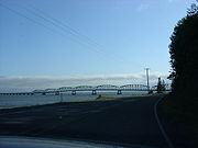
of Washington. The highway originates at the north end of the Astoria–Megler Bridge west of Megler
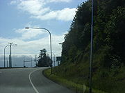
at an intersection with (US 101). The roadway travels northeast, paralleling cliffs, the Columbia River
and the South Fork of the Naselle River
to Naselle
, ending at . The road was designated Secondary State Highway 12B (SSH 12) between 1937 and 1964, when SR 401 was created to replace SSH 12B. The Astoria–Megler Bridge, completed in 1966, replaced a ferry east of the bridge, where the highway originally ended, and is known locally as Kingston Ferry Road. The roadway was extended west to the north end of the bridge, where it currently terminates. The former ferry terminal became the Dismal Nitch
rest area
, named after the Lewis and Clark Expedition
's description of the place.
 SR 401 originates at an intersection with (US 101) at the north end of the Astoria–Megler Bridge west of Megler
and southeast of McGowan
. Traveling northeast between cliffs and the Columbia River
past the Dismal Nitch
Safety rest area
to Knappton, the highway turns north along more cliffs and the South Fork of the Naselle River
. In Naselle
, the South Fork merges with the Naselle River, which the roadway crosses over three times before terminating at . The intersection with SR 4 is also the busiest segment of the road with an estimated daily average of 2,800 motorists, which has been decreasing from 3,100 motorists in 2005.
 Secondary State Highway 12B (SSH 12B) was created during the 1937 establishment of the Primary and secondary state highway system as an auxiliary route
of (PSH 12), co-signed as both (US 101) and . The highway ran from PSH 12 / US 101 at the Megler
ferry landing on the Columbia River
to PSH 12 / US 830 in Naselle
, with a gap between Megler and Knappton. SSH 12B, including the Megler–Knappton gap, became SR 401 during the 1964 highway renumbering
. After the Astoria–Megler Bridge was completed on 27 August 1966, SR 401 was extended west to the new bridge and the gap between Megler and Knappton was completed by 1968. The Dismal Nitch Safety rest area
, formerly the Megler Landing Rest Area, was remodeled twice in 2007 to be accessible year-round.
State highways in Washington
In the U.S. state of Washington, the Washington State Department of Transportation maintains a network of over 7000 miles of state highways, including all Interstate and U.S. Highways that pass through the state. The system comprises 8.5% of the state's public road mileage, but carries over half...
in Pacific County within the U.S. state
U.S. state
A U.S. state is any one of the 50 federated states of the United States of America that share sovereignty with the federal government. Because of this shared sovereignty, an American is a citizen both of the federal entity and of his or her state of domicile. Four states use the official title of...
of Washington. The highway originates at the north end of the Astoria–Megler Bridge west of Megler
Megler, Washington
Megler is a small community located in Pacific County in the U.S. state of Washington. Named for legislator Joseph G. Megler, the community is located at the mouth of the Columbia River on the north shore of the river...
at an intersection with (US 101). The roadway travels northeast, paralleling cliffs, the Columbia River
Columbia River
The Columbia River is the largest river in the Pacific Northwest region of North America. The river rises in the Rocky Mountains of British Columbia, Canada, flows northwest and then south into the U.S. state of Washington, then turns west to form most of the border between Washington and the state...
and the South Fork of the Naselle River
Naselle River
The Naselle River is a river in the U.S. state of Washington.-Course:The Naselle River originates in the Willapa Hills and flows generally west, passing the community of Naselle before emptying into the southern part of Willapa Bay....
to Naselle
Naselle, Washington
Naselle is a census-designated place in Pacific County, Washington, United States. The population was 419 at the 2010 census. Though very near Columbia River's estuary, the valley's Naselle River flows west into nearby Willapa Bay and then into the Pacific Ocean. Close about the town lie the...
, ending at . The road was designated Secondary State Highway 12B (SSH 12) between 1937 and 1964, when SR 401 was created to replace SSH 12B. The Astoria–Megler Bridge, completed in 1966, replaced a ferry east of the bridge, where the highway originally ended, and is known locally as Kingston Ferry Road. The roadway was extended west to the north end of the bridge, where it currently terminates. The former ferry terminal became the Dismal Nitch
Dismal Nitch
Dismal Nitch is the name of a cove along the lower Columbia River in Washington State, notable as the Lewis and Clark Expedition's last campsite before sighting the Pacific Ocean...
rest area
Rest area
A rest area, travel plaza, rest stop, or service area is a public facility, located next to a large thoroughfare such as a highway, expressway, or freeway at which drivers and passengers can rest, eat, or refuel without exiting on to secondary roads...
, named after the Lewis and Clark Expedition
Lewis and Clark Expedition
The Lewis and Clark Expedition, or ″Corps of Discovery Expedition" was the first transcontinental expedition to the Pacific Coast by the United States. Commissioned by President Thomas Jefferson and led by two Virginia-born veterans of Indian wars in the Ohio Valley, Meriwether Lewis and William...
's description of the place.
Route description
Megler, Washington
Megler is a small community located in Pacific County in the U.S. state of Washington. Named for legislator Joseph G. Megler, the community is located at the mouth of the Columbia River on the north shore of the river...
and southeast of McGowan
McGowan, Washington
McGowan, Washington was a stop on the Ilwaco Railway and Navigation Company's narrow gauge line that ran on the Long Beach Peninsula in Pacific County, Washington, USA from 1889 to 1930. In the late 19th century, P.J. McGowan bought land in the area for $1,200, and built his house and a dock and a...
. Traveling northeast between cliffs and the Columbia River
Columbia River
The Columbia River is the largest river in the Pacific Northwest region of North America. The river rises in the Rocky Mountains of British Columbia, Canada, flows northwest and then south into the U.S. state of Washington, then turns west to form most of the border between Washington and the state...
past the Dismal Nitch
Dismal Nitch
Dismal Nitch is the name of a cove along the lower Columbia River in Washington State, notable as the Lewis and Clark Expedition's last campsite before sighting the Pacific Ocean...
Safety rest area
Rest area
A rest area, travel plaza, rest stop, or service area is a public facility, located next to a large thoroughfare such as a highway, expressway, or freeway at which drivers and passengers can rest, eat, or refuel without exiting on to secondary roads...
to Knappton, the highway turns north along more cliffs and the South Fork of the Naselle River
Naselle River
The Naselle River is a river in the U.S. state of Washington.-Course:The Naselle River originates in the Willapa Hills and flows generally west, passing the community of Naselle before emptying into the southern part of Willapa Bay....
. In Naselle
Naselle, Washington
Naselle is a census-designated place in Pacific County, Washington, United States. The population was 419 at the 2010 census. Though very near Columbia River's estuary, the valley's Naselle River flows west into nearby Willapa Bay and then into the Pacific Ocean. Close about the town lie the...
, the South Fork merges with the Naselle River, which the roadway crosses over three times before terminating at . The intersection with SR 4 is also the busiest segment of the road with an estimated daily average of 2,800 motorists, which has been decreasing from 3,100 motorists in 2005.
History
Auxiliary route
In road transportation, a special route is a prefixed and/or suffixed numbered road that forms a loop or spur of a more dominant route of the same route number and system. The dominant route is generally referred to as the "parent" or "mainline", while special routes are also unofficially or...
of (PSH 12), co-signed as both (US 101) and . The highway ran from PSH 12 / US 101 at the Megler
Megler, Washington
Megler is a small community located in Pacific County in the U.S. state of Washington. Named for legislator Joseph G. Megler, the community is located at the mouth of the Columbia River on the north shore of the river...
ferry landing on the Columbia River
Columbia River
The Columbia River is the largest river in the Pacific Northwest region of North America. The river rises in the Rocky Mountains of British Columbia, Canada, flows northwest and then south into the U.S. state of Washington, then turns west to form most of the border between Washington and the state...
to PSH 12 / US 830 in Naselle
Naselle, Washington
Naselle is a census-designated place in Pacific County, Washington, United States. The population was 419 at the 2010 census. Though very near Columbia River's estuary, the valley's Naselle River flows west into nearby Willapa Bay and then into the Pacific Ocean. Close about the town lie the...
, with a gap between Megler and Knappton. SSH 12B, including the Megler–Knappton gap, became SR 401 during the 1964 highway renumbering
1964 state highway renumbering (Washington)
In 1963, a law was passed authorizing a new numbering for sign routes. In 1970 the legislative definitions were changed to use the sign route numbers but renamed state routes...
. After the Astoria–Megler Bridge was completed on 27 August 1966, SR 401 was extended west to the new bridge and the gap between Megler and Knappton was completed by 1968. The Dismal Nitch Safety rest area
Rest area
A rest area, travel plaza, rest stop, or service area is a public facility, located next to a large thoroughfare such as a highway, expressway, or freeway at which drivers and passengers can rest, eat, or refuel without exiting on to secondary roads...
, formerly the Megler Landing Rest Area, was remodeled twice in 2007 to be accessible year-round.
Major intersections
The highway is located entirely in Pacific County.| Location | Mile | Destinations | Notes |
|---|---|---|---|
| Megler Megler, Washington Megler is a small community located in Pacific County in the U.S. state of Washington. Named for legislator Joseph G. Megler, the community is located at the mouth of the Columbia River on the north shore of the river... |
0.00 | – Astoria Astoria, Oregon Astoria is the county seat of Clatsop County, Oregon, United States. Situated near the mouth of the Columbia River, the city was named after the American investor John Jacob Astor. His American Fur Company founded Fort Astoria at the site in 1811... , Ilwaco Ilwaco, Washington Ilwaco is a city in Pacific County, Washington, United States. The population was 950 at the 2000 census and decreased to 936 at the 2010 census.-History:... |
Southern terminus |
| Naselle Naselle, Washington Naselle is a census-designated place in Pacific County, Washington, United States. The population was 419 at the 2010 census. Though very near Columbia River's estuary, the valley's Naselle River flows west into nearby Willapa Bay and then into the Pacific Ocean. Close about the town lie the... |
12.13 | Northern terminus |