
State Line Avenue
Encyclopedia

Arterial road
An arterial road, or arterial thoroughfare, is a high-capacity urban road. The primary function of an arterial road is to deliver traffic from collector roads to freeways, and between urban centres at the highest level of service possible. As such, many arteries are limited-access roads, or feature...
in Texarkana, United States
United States
The United States of America is a federal constitutional republic comprising fifty states and a federal district...
. It follows approximately eleven miles of the Texas
Texas
Texas is the second largest U.S. state by both area and population, and the largest state by area in the contiguous United States.The name, based on the Caddo word "Tejas" meaning "friends" or "allies", was applied by the Spanish to the Caddo themselves and to the region of their settlement in...
-Arkansas
Arkansas
Arkansas is a state located in the southern region of the United States. Its name is an Algonquian name of the Quapaw Indians. Arkansas shares borders with six states , and its eastern border is largely defined by the Mississippi River...
state line, and divides the city into two separate municipal units. The street's centerline does not follow the state boundary precisely, but the southbound lanes of State Line Avenue are located in Texarkana, Texas
Texarkana, Texas
Texarkana is a city in Bowie County, Texas, United States. It effectively functions as one half of a city which crosses a state line — the other half, the city of Texarkana, Arkansas, lies on the other side of State Line Avenue...
(Bowie County
Bowie County, Texas
Bowie County is a county located in the U.S. state of Texas. It is part of the Texarkana, Texas - Texarkana, Arkansas, Metropolitan Statistical Area. As of 2000, the population was 89,306. Its legal county seat is Boston, though its courthouse is located in New Boston...
), and the northbound lanes are in Texarkana, Arkansas
Texarkana, Arkansas
As of the census of 2000, there were 26,448 people, 10,384 households, and 7,040 families residing in the city. The population density was 830.5 people per square mile . There were 11,721 housing units at an average density of 368.1 per square mile...
(Miller County).
State Line Avenue consists of two non-continuous portions, separated by a one-mile (1.6 km) gap directly south of the downtown area.
North State Line Avenue carries the US 59/US 71 concurrency, south of the Red River
Red River (Mississippi watershed)
The Red River, or sometimes the Red River of the South, is a major tributary of the Mississippi and Atchafalaya Rivers in the southern United States of America. The river gains its name from the red-bed country of its watershed. It is one of several rivers with that name...
bridge. The northern part of this route runs a few hundred feet west of the state line. From Highway 296 (Sugar Hill Road) south to 6th Street downtown, the roadway straddles the boundary line.
A concentration of hotels dominates the four quadrants of the State Line Avenue/Interstate 30
Interstate 30
Interstate 30 is an Interstate Highway in the southern United States. I-30 runs from Interstate 20 west of Fort Worth, Texas, northeast via Dallas, Texas, and Texarkana, Texas, to Interstate 40 in North Little Rock, Arkansas. The route parallels U.S. Route 67 except for the portion west of...
interchange
Interchange (road)
In the field of road transport, an interchange is a road junction that typically uses grade separation, and one or more ramps, to permit traffic on at least one highway to pass through the junction without directly crossing any other traffic stream. It differs from a standard intersection, at which...
, with over a dozen different lodging chains being represented at this exit. At this interchange, U.S. Route 59
U.S. Route 59
U.S. Route 59 is a north–south United States highway . A latecomer to the U.S. numbered route system, U.S. 59 is now a border-to-border route, Part of NAFTA Corridor Highway System. It parallels U.S. Route 75 for nearly its entire route, never much more than away, until it veers southwest...
splits from US 71, following I-30 westward for 3.5 miles (5.6 km), before heading southward on its own alignment.
Because Bowie County, Texas
Bowie County, Texas
Bowie County is a county located in the U.S. state of Texas. It is part of the Texarkana, Texas - Texarkana, Arkansas, Metropolitan Statistical Area. As of 2000, the population was 89,306. Its legal county seat is Boston, though its courthouse is located in New Boston...
is "dry
Dry county
A dry county is a county in the United States whose government forbids the sale of alcoholic beverages. Some prohibit off-premises sale, some prohibit on-premises sale, and some prohibit both. Hundreds of dry counties exist across the United States, almost all of them in the South...
", several liquor store
Liquor store
In the United States, Australia and Canada, a liquor store is a type of store that specializes in the sale of alcoholic beverages. In South Africa and Namibia these stores are generally called bottle stores....
s line the Arkansas side
Texarkana, Arkansas
As of the census of 2000, there were 26,448 people, 10,384 households, and 7,040 families residing in the city. The population density was 830.5 people per square mile . There were 11,721 housing units at an average density of 368.1 per square mile...
of midtown State Line Avenue. Customers from Texas regularly cross the state line to purchase alcoholic beverages. State Line remains a five-lane street carrying U.S. Route 71
U.S. Route 71
U.S. Route 71 is a north–south United States highway. This original 1926 route has remained largely unchanged by encroaching Interstate highways. Currently, the highway's northern terminus is in International Falls, Minnesota at the Canadian border, at the southern end of the Fort...
, lined with retail outlets, for about four more miles before intersecting US 67/US 82 and entering downtown Texarkana. From here, US 71 turns sharply eastward, into a short wrong-way concurrency with U.S. Route 67
U.S. Route 67
U.S. Route 67 is a 1,560 mile long north–south U.S. highway in the Central United States. The southern terminus of the route is at the United States-Mexico border in Presidio, Texas, where it continues south as Mexican Federal Highway 16 upon crossing the Rio Grande. The northern...
, before again turning southeast towards Shreveport, Louisiana
Shreveport, Louisiana
Shreveport is the third largest city in Louisiana. It is the principal city of the fourth largest metropolitan area in the state of Louisiana and is the 109th-largest city in the United States....
.
From here, State Line Avenue continues south. One block south of US 67/US 82, the street splits apart. The traffic island
Traffic island
A traffic island is a solid or painted object in a road that channelises traffic. It can also be a narrow strip of island between roads that intersect at an acute angle. If the island uses road markings only, without raised kerbs or other physical obstructions, it is called a painted island...
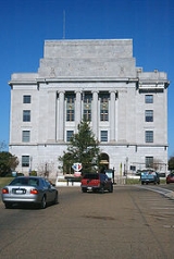
in the middle is occupied by the city's U.S. Post Office and Federal Building, the only such building to be located in two states.
Until 1980, State Line Avenue terminated at Texarkana Union Station, but it now ends at Broad Street. At the west end of downtown, the "Texas Viaduct" carries traffic over a rail yard to South State Line Avenue. Approximately five miles south of the viaduct the road veers eastward, becoming Miller County Road 28, en route to Pleasant Hill.
Destinations
| Texas | Arkansas | |||||
|---|---|---|---|---|---|---|
| ← Denison Denison, Texas Denison is a city in Grayson County, Texas, United States. The population was 22,773 at the 2000 census; it is estimated to have grown to 24,127 in 2009. Denison is one of two principal cities in the Sherman-Denison Metropolitan Statistical Area.-History:... |
Red River Red River (Mississippi watershed) The Red River, or sometimes the Red River of the South, is a major tributary of the Mississippi and Atchafalaya Rivers in the southern United States of America. The river gains its name from the red-bed country of its watershed. It is one of several rivers with that name... |
Fulton Fulton, Arkansas Fulton is a city in Hempstead County, Arkansas, United States. The population was 245 at the 2000 census. It is part of the Hope Micropolitan Statistical Area... → |
||||
| ← Northridge Country Club | Lakeridge Dr. | Sugar Hill Road | Highway 296 Arkansas Highway 296 Highway 296 is a mostly east–west highway in southwestern Arkansas, USA.Section 1 begins at U.S. Route 71 & U.S. Route 59 at Texarkana. It travels east approximately ending at U.S. Route 67 northeast of Texarkana.... → |
|||
| ← Aledo Aledo, Texas Aledo is a city in Parker County, Texas, United States. The population was 1,726 at the 2000 census.The city is served by the Aledo Independent School District.-Geography:... |
 W I-30 W I-30 |
Interstate 30 Interstate 30 Interstate 30 is an Interstate Highway in the southern United States. I-30 runs from Interstate 20 west of Fort Worth, Texas, northeast via Dallas, Texas, and Texarkana, Texas, to Interstate 40 in North Little Rock, Arkansas. The route parallels U.S. Route 67 except for the portion west of... |
E I-30 |
North Little Rock North Little Rock, Arkansas the city was 62.55% White, 33.98% Black or African American, 0.41% Native American, 0.59% Asian, 0.03% Pacific Islander, 1.18% from other races, and 1.26% from two or more races... → |
||
| ← Laredo Laredo, Texas Laredo is the county seat of Webb County, Texas, United States, located on the north bank of the Rio Grande in South Texas, across from Nuevo Laredo, Tamaulipas, Mexico. According to the 2010 census, the city population was 236,091 making it the 3rd largest on the United States-Mexican border,... |
 S US 59 S US 59 |
|||||
| ← S Loop 14 | Texas Blvd | Arkansas Blvd | Texarkana Regional Airport → | |||
| ← Presidio Presidio, Texas Presidio is a city in Presidio County, Texas, United States. It stands on the Rio Grande , on the opposite side of the U.S.-Mexico border from Ojinaga, Chihuahua. The population was 4,167 at the 2000 census.... |
 S US 67 S US 67 |
Dr. Martin Luther King, Jr. Blvd/ East 7th Street |
N US 67 |
Sabula Sabula, Iowa Sabula is a city in Jackson County, Iowa, United States. The population was 670 at the 2000 census. Sabula is the site of Iowa's only island city. The island has a beach and a campground. It also has a harbor with boat docks and storage sheds to store some boats during the winter... → |
||
| ← Alamogordo Alamogordo, New Mexico Alamogordo is the county seat of Otero County and a city in south-central New Mexico, United States. A desert community lying in the Tularosa Basin, it is bordered on the east by the Sacramento Mountains. It is the nearest city to Holloman Air Force Base. The population was 35,582 as of the 2000... |
 W US 82 W US 82 |
 S US 71 S US 71 |
Krotz Springs Krotz Springs, Louisiana Krotz Springs is a town in St. Landry Parish, Louisiana on the Atchafalaya River. The population was 1,219 at the 2000 census. It is part of the Opelousas–Eunice Micropolitan Statistical Area.-History:... → |
|||
| E US 82 |
Brunswick Brunswick, Georgia Brunswick is the major urban and economic center in southeastern Georgia in the United States. The municipality is located on a harbor near the Atlantic Ocean, approximately 30 miles north of Florida and 70 miles south of South Carolina. Brunswick is bordered on the east by the Atlantic... → |
|||||
| ← N Loop 151 | The Loop Loop (Texarkana) The Loop is a beltway around Texarkana, a twin city in the U.S. states of Arkansas and Texas, running about 16 miles . Consisting of Highway 245 - sometimes called Loop 245 - in Arkansas, and Loop 151 and a section of U.S. Highway 59 in Texas, it forms a three-quarter loop around the east, south... |
N Highway 245 → | ||||