
.gif)
State Highway 14 (Oklahoma)
Encyclopedia
State Highway 14, also abbreviated as SH-14 or OK-14, is a highway maintained by the U.S.
state of Oklahoma
. It is 15 miles (24.1 km) miles long, with its entire route falling in Woods Co.
in the northwestern part of the state. It does not have any lettered spur routes.
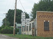
in Waynoka
. From this point, the highway heads west for a few blocks on the north edge of Waynoka. It then turns north and, after curving slightly to the east, follows a due north course to U.S. Highway 64 east of Cora.
Signage present along the road indicates that SH-14 ends at US-64. However, both the Oklahoma state highway map and ODOT's internal control section maps show SH-14 turning east at this intersection. SH-14 then overlaps
US-64, unsigned
, into Alva
, the county seat. The route continues through Alva, where US-64 and unsigned SH-14 overlap US-281. On the east side of the town, US-281 splits off to the north; this intersection is the end of SH-14.
 State Highway 14 has its roots in the original 1924 state highway system. SH-14, as designated on 1924-08-24, was a border-to-border route. It began at SH-5 east of Frederick
and proceeded north to Manitou
. It then intersected SH-7 in Snyder
and ran through Mountain Park
shortly thereafter. The route then zig-zagged to the northwest towards Roosevelt
. It then ran due north to the Hobart
area, beginning a concurrency with SH-9 east of that town. After SH-9 split off to the east, SH-14 entered Washita County
, where it intersected no other highways, but ran through the towns of Rocky
, Cordell (the county seat), and Bessie
. Just after crossing into Custer County
, the highway had a concurrency with SH-3; the two routes split up in Clinton
. SH-14 continued on a due north course through Arapaho
, Putnam
, and Taloga
. In Seiling
, SH-14 turned west, overlapping SH-13 through Cestos to a point just east of Vici
, where SH-14 split away from SH-13. SH-14 then passed through Sharon
en route to Woodward
. It concurred with SH-15 to Tangier, then split off to the north to run through Fort Supply
before ending at SH-11 east of Buffalo
.
Unlike many of the other original highways, SH-14 was not immediately affected by the introduction of the United States Numbered Highways
system in 1929. However, SH-14 underwent its first alteration in 1929, when it was extended south through Frederick and Davidson
to the Texas
state line.
By the end of 1931, State Highway 14 had been realigned north of Seiling. From Seiling, the road continued north (rather than concurring with what was by then US-60 towards Vici) to Chester
and Waynoka. From Waynoka, the route continued north along present-day U.S. 281 through Alva to the state line south of Hardtner, Kansas
. (The old road north of Vici became part of SH-34.)
New U.S. routes were added to Oklahoma's highway system in 1938. Among these were US-281, formerly a split route with one section in Kansas and one in Texas, which was connected in 1938 via Oklahoma; also added in 1938 was a southern extension of US-183. These two routes were overlaid onto SH-14, with US-183 entering the state from the south near Davidson and following the SH-14 route to Seiling, and US-281 taking the remainder of the route.
SH-14 was rerouted to follow an independent routing northward from Waynoka (the present day routing) in 1940, and the section of the highway connecting Alva to the Kansas line was dropped (making this road solely US-281). The rest of the highway, still concurrent with US-183 and US-281, was decommissioned the following year, leaving SH-14 at its present-day termini. No changes have been made to SH-14 since.
United States
The United States of America is a federal constitutional republic comprising fifty states and a federal district...
state of Oklahoma
Oklahoma
Oklahoma is a state located in the South Central region of the United States of America. With an estimated 3,751,351 residents as of the 2010 census and a land area of 68,667 square miles , Oklahoma is the 28th most populous and 20th-largest state...
. It is 15 miles (24.1 km) miles long, with its entire route falling in Woods Co.
Woods County, Oklahoma
Woods County is a county located in the U.S. state of Oklahoma. As of 2000, the population was 9,089. Its county seat is Alva. The county is named after Samuel Newitt Wood, a renowned Kansas populist. -Geography:According to the U.S...
in the northwestern part of the state. It does not have any lettered spur routes.
Route description
SH-14 begins at U.S. Highway 281/State Highway 45State Highway 45 (Oklahoma)
State Highway 45 is a state highway in Oklahoma. It runs west-to-east through Woods, Alfalfa and Garfield counties.-Route description:SH-45 begins at the US-281/SH-14 junction in Waynoka...
in Waynoka
Waynoka, Oklahoma
Waynoka is a city in Woods County, Oklahoma, United States. The population was 927 at the 2010 census. It is 4 miles away from Little Sahara State Park.-Geography:Waynoka is located at ....
. From this point, the highway heads west for a few blocks on the north edge of Waynoka. It then turns north and, after curving slightly to the east, follows a due north course to U.S. Highway 64 east of Cora.
Signage present along the road indicates that SH-14 ends at US-64. However, both the Oklahoma state highway map and ODOT's internal control section maps show SH-14 turning east at this intersection. SH-14 then overlaps
Concurrency (road)
A concurrency, overlap, or coincidence in a road network is an instance of one physical road bearing two or more different highway, motorway, or other route numbers...
US-64, unsigned
Unsigned highway
An unsigned highway is a highway that has been assigned a route number, but does not bear conventional road markings that would normally be used to identify the route with that number...
, into Alva
Alva, Oklahoma
Alva is a city in Woods County, Oklahoma, along the Salt Fork Arkansas River. The population was 4,945 at the 2010 census. It is the county seat of Woods County....
, the county seat. The route continues through Alva, where US-64 and unsigned SH-14 overlap US-281. On the east side of the town, US-281 splits off to the north; this intersection is the end of SH-14.
History
Frederick, Oklahoma
Frederick is a city in Tillman County, Oklahoma, United States. The population was 3,940 at the 2010 census. It is the county seat of Tillman County. This is an agriculture based community primarily with wheat, cotton, and cattle....
and proceeded north to Manitou
Manitou, Oklahoma
Manitou is a town in Tillman County, Oklahoma, United States. The population was 181 at the 2010 census. It includes the former town of Siboney, absorbed on January 28, 1908...
. It then intersected SH-7 in Snyder
Snyder, Oklahoma
Snyder is a city in Kiowa County, Oklahoma, United States. The population was 1,394 at the 2010 census.-Geography:Snyder is located at .According to the United States Census Bureau, Snyder has a total area of , all of it land....
and ran through Mountain Park
Mountain Park, Oklahoma
Mountain Park is a town in Kiowa County, Oklahoma, United States. The population was 409 at the 2010 census.-Embezzlement:On March 7, 2008, KSWO-TV reported that the former town clerk was fired for allegedly secretly embezzling $100,000 over a period of two years, leaving the town unable to pay its...
shortly thereafter. The route then zig-zagged to the northwest towards Roosevelt
Roosevelt, Oklahoma
Roosevelt is a town in Kiowa County, Oklahoma, United States. The population was 248 at the 2010 census.-Geography:Roosevelt is located at .According to the United States Census Bureau, the town has a total area of , all of it land....
. It then ran due north to the Hobart
Hobart, Oklahoma
Hobart is a city in and the county seat of Kiowa County, Oklahoma, United States. Hobart was founded in 1901 on what had been part of an Indian reservation. The settlers drew lots for free land. It was named for Garret Hobart, the twenty-fourth Vice President of the United States. The population...
area, beginning a concurrency with SH-9 east of that town. After SH-9 split off to the east, SH-14 entered Washita County
Washita County, Oklahoma
Washita County is a county located in the U.S. state of Oklahoma. As of 2000, the population was 11,508. Its county seat is New Cordell. It was formerly located in Cloud Chief, Oklahoma....
, where it intersected no other highways, but ran through the towns of Rocky
Rocky, Oklahoma
Rocky is a town in Washita County, Oklahoma, United States. The population was 174 at the 2000 census.-Geography:Rocky is located at .According to the United States Census Bureau, the town has a total area of , all of it land....
, Cordell (the county seat), and Bessie
Bessie, Oklahoma
Bessie is a town in Washita County, Oklahoma, United States. The population was 181 at the 2010 census.-Geography:Bessie is located at .According to the United States Census Bureau, the town has a total area of , all of it land....
. Just after crossing into Custer County
Custer County, Oklahoma
Custer County is a county located in the U.S. state of Oklahoma. It was named in honor of General George Armstrong Custer. As of 2000, the population was 26,142. Its county seat is Arapaho.-Geography:...
, the highway had a concurrency with SH-3; the two routes split up in Clinton
Clinton, Oklahoma
Clinton is a city in Custer and Washita counties in the U.S. state of Oklahoma. The population was 9,033 at the 2010 census.-History:The community began in 1899 when two men, J.L. Avant and E.E...
. SH-14 continued on a due north course through Arapaho
Arapaho, Oklahoma
Arapaho is a town in Custer County, Oklahoma, United States. The population was 796 at the 2010 census. It is the county seat of Custer County. Its name derives from the Arapaho Indians.-Geography:Arapaho is located at ....
, Putnam
Putnam, Oklahoma
Putnam is a town in Dewey County, Oklahoma, United States. The population was 46 at the 2000 census.-Geography:Putnam is located at .According to the United States Census Bureau, the town has a total area of , all of it land....
, and Taloga
Taloga, Oklahoma
Taloga is a town in Dewey County, Oklahoma, United States. The population was 299 at the 2010 census. It is the county seat of Dewey County.-Geography:Taloga is located at ....
. In Seiling
Seiling, Oklahoma
Seiling is a city in Dewey County, Oklahoma, United States. The population was 860 at the 2010 census.-Geography:Seiling is located at .According to the United States Census Bureau, the city has a total area of , all of it land....
, SH-14 turned west, overlapping SH-13 through Cestos to a point just east of Vici
Vici, Oklahoma
Vici is a town in Dewey County, Oklahoma, United States. The population was 699 at the 2010 census.-Geography:Vici is located at .According to the United States Census Bureau, the town has a total area of , all of it land....
, where SH-14 split away from SH-13. SH-14 then passed through Sharon
Sharon, Oklahoma
Sharon is a town in Woodward County, Oklahoma, United States. The population was 135 at the 2010 census.-Geography:Sharon is located at .According to the United States Census Bureau, the town has a total area of , all of it land....
en route to Woodward
Woodward, Oklahoma
Woodward is a city in and the county seat of Woodward County, Oklahoma, United States. It is the largest city in a nine-county area. The population was 12,051 at the 2010 census....
. It concurred with SH-15 to Tangier, then split off to the north to run through Fort Supply
Fort Supply, Oklahoma
Fort Supply is a town in Woodward County, Oklahoma, United States. The population was 330 at the 2010 census.-History:Fort Supply, is a town established one mile West of Camp Supply, a United States Army post established on November 18, 1868 as a "Camp of Supply" for the winter campaign against the...
before ending at SH-11 east of Buffalo
Buffalo, Oklahoma
Buffalo is a town in Harper County, Oklahoma, United States. The population was 1,299 at the 2010 census. It is the county seat of Harper County.-Geography:According to the United States Census Bureau, Buffalo has a total area of , all land.-Climate:...
.
Unlike many of the other original highways, SH-14 was not immediately affected by the introduction of the United States Numbered Highways
United States Numbered Highways
The system of United States Numbered Highways is an integrated system of roads and highways in the United States numbered within a nationwide grid...
system in 1929. However, SH-14 underwent its first alteration in 1929, when it was extended south through Frederick and Davidson
Davidson, Oklahoma
Davidson is a town in Tillman County, Oklahoma, United States. The population was 315 at the 2010 census. The town experienced a minor flood in 1995.-Geography:Davidson is located at ....
to the Texas
Texas
Texas is the second largest U.S. state by both area and population, and the largest state by area in the contiguous United States.The name, based on the Caddo word "Tejas" meaning "friends" or "allies", was applied by the Spanish to the Caddo themselves and to the region of their settlement in...
state line.
By the end of 1931, State Highway 14 had been realigned north of Seiling. From Seiling, the road continued north (rather than concurring with what was by then US-60 towards Vici) to Chester
Chester, Oklahoma
Chester is a rural unincorporated community in Major County, Oklahoma. The post office opened April 8, 1895. The ZIP Code is 73838. It is said to have been named for Chester I. Long, US Senator from Kansas.-Sources:...
and Waynoka. From Waynoka, the route continued north along present-day U.S. 281 through Alva to the state line south of Hardtner, Kansas
Hardtner, Kansas
Hardtner is a city in Barber County, Kansas, United States. As of the 2010 census, the city population was 172.-History:By 1908 the townspeople had realized that they would need a railroad line to the outside world in order to survive. The town's founder Jacob Achenbach, helped set up a company to...
. (The old road north of Vici became part of SH-34.)
New U.S. routes were added to Oklahoma's highway system in 1938. Among these were US-281, formerly a split route with one section in Kansas and one in Texas, which was connected in 1938 via Oklahoma; also added in 1938 was a southern extension of US-183. These two routes were overlaid onto SH-14, with US-183 entering the state from the south near Davidson and following the SH-14 route to Seiling, and US-281 taking the remainder of the route.
SH-14 was rerouted to follow an independent routing northward from Waynoka (the present day routing) in 1940, and the section of the highway connecting Alva to the Kansas line was dropped (making this road solely US-281). The rest of the highway, still concurrent with US-183 and US-281, was decommissioned the following year, leaving SH-14 at its present-day termini. No changes have been made to SH-14 since.