
St. James railway station, Sydney
Encyclopedia
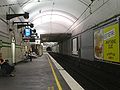
St James is an underground railway station
on the City Circle
line in Sydney
, Australia
. The station is located under the northern end of Hyde Park
, and is named after nearby St James Church
. With entrances on Elizabeth Street, St James Road, and in Queens Square, St James Station serves the Inner West, the East Hills, the South Line
, and the Bankstown Line.
Annual ridership to/from St James Railway Station: 2.3 million journeys
 Part of the Bradfield Plan, St James Railway Station was originally intended to be a major interchange with the eastern suburbs railway line on Sydney's underground rail system
. Plans for the construction of St James included railway lines in four directions, but the original plan was never completed due to disagreements over the routes. Four platforms were completed, but the two inner platforms, intended to support Bradfield's proposed eastern and western suburbs lines, were never put into service.
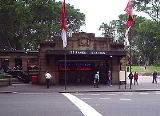
The station itself was designed by NSWGA architect George McRae
, but not completed until after his death. An example of Inter-War Stripped Classical architecture
influenced by Art Deco
, St James Station serves the starting point for the City of Sydney Commerce walking tour. One distinctive feature of the station is a neon sign from the late 1930s advertising Chateau Tanunda Brandy installed by Tucker, Lingard & Co., located at the northern entrance on Elizabeth Street.
Regular service to St James Station began on 20 December 1926 with the opening of the eastern Central line to Museum Station. For the first thirty years of its existence, St James Station was used as a terminating station for the Bankstown, East Hills and Illawarra lines. As a terminating station, St James was equipped with a small signal box and two dead end sidings, located in the tunnel stub at the north end of the station. Trains arriving at St James would disembark passengers on one of the outer platforms, then the train would move to a siding and reverse direction, coming out at the opposite outer platform. During non-peak hours the driver would simply move to the other end of the train while the train was on the siding. During peak hours the train would take on a second driver in the last car while at the platform, then proceed to one of the sidings, where the drivers would exchange control of the train.
Still in place, the signal box equipped with pistol grips is the smallest such box in the state. The signal box remained in use until the mid 1980s, but was taken out of service from 1985 to 1986 during an asbestos abatement project. When not in use, the train cars allocated for the removal of the asbestos would occupy one or the other of the dead end sidings, and then meant that regular use of those lines by passenger trains was not possible. Without regular use, the rails became rusty, and this made the track circuits unreliable (since the circuits depend on current passing from one rail through the train's wheels and axle to the other track). After the asbestos abatement project was completed, the signal box was returned to service until 1990, when asbestos was discovered in the signal box and the sidings. From that time, the signal box was not used, and the signals on the sidings and main lines were removed.
Completion of the City Circle
loop was not completed until thirty years after St James Station opened for service. Construction of the western Central line as far as Wynyard station
was completed in 1932, but completion of the line connecting Wynyard station
and St James through Circular Quay, begun in 1936, proved problematic. Construction was halted during World War II, and after 1945, construction was intermittent due to inconsistent funding. By 1953 it was determined that work underground could not proceed at Circular Quay due to water entering the tunnels. A section of rail line above ground was constructed, and the City Circle
loop was completed in 1956.
In 2010, St James was upgraded to Easy Access status with the provision of a passenger lift between the platform and the concourse in February, and later a lift between the concourse and street level.
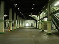 St James Station is most notable for the abandoned tunnels connected to the station. The Australian Railway Historical Society
, with the approval of the State Rail Authority, has given tours of the tunnels, but many people have visited the tunnels by entering along the subway tracks. The tunnels were constructed as stubs for the planned eastern and western suburbs lines when the station was built in the 1920s. This was to ensure that the operation of St James would not be disrupted if future work was carried out on the lines. The abandoned tunnels extend some distance in either direction from St James. They proceed for some 250 metres north under Macquarie Street to be roughly parallel with the State Library; to the south they extend to Whitlam Square at the intersection of Liverpool and College Streets.
to serve as a public air raid shelter. The abandoned air raid shelter begins in the double track tunnel section at the north end of St James Station, and continues into the two single track tunnels beyond. At the station end, the air raid shelter is protected by a blast curtain, and the doorways and openings for ventilation between the chambers, each about 30 metres long, are protected by blast curtains.
The tunnels were also used during World War II as an operations bunker by the No. 1 Fighter Sector RAAF
.
The bunker was located in what was intended to be the City Inner Tunnel, access to which was provided by a wooden staircase in a shaft leading upward to Shakespeare Place. WAAAF
personnel housed in this operations bunker collected information from radar and weather stations, as well as reports on air traffic, ship and troop movements collected from airports, army and Volunteer Air Observer Corps
reporting posts. This section of tunnel was constructed using a cut and cover technique outside of St James Station, and connects to the tunnels in St James through pilot tunnels, accessible via ladder.
As air quality in the tunnel was poor, WAAAF shifts were limited to six hours. Eventually the health of the WAAAF personnel declined due to poor air quality or poor food, so operations were relocated first to The Capital Theatre in Bankstown, and subsequently to the Bankstown Bunker
on Black Charlies hill near Condell Park
.
The staircase used to access the bunker was destroyed by fire on 16 of November, 1968. Smoke from this fire interrupted train service for approximately twelve hours.
There have also been rumors that General MacArthur had a secret bunker facility in one of the tunnels, but these rumors have not been substantiated.
St James is an underground railway station
on the City Circle
line in Sydney
, Australia
. The station is located under the northern end of Hyde Park
, and is named after nearby St James Church
. With entrances on Elizabeth Street, St James Road, and in Queens Square, St James Station serves the Inner West, the East Hills, the South Line
, and the Bankstown Line.
Annual ridership to/from St James Railway Station: 2.3 million journeys
Part of the Bradfield Plan, St James Railway Station was originally intended to be a major interchange with the eastern suburbs railway line
on Sydney's underground rail system
. Plans for the construction of St James included railway lines in four directions, but the original plan was never completed due to disagreements over the routes. Four platforms were completed, but the two inner platforms, intended to support Bradfield's proposed eastern and western suburbs lines, were never put into service.
The station itself was designed by NSWGA architect George McRae
, but not completed until after his death. An example of Inter-War Stripped Classical architecture
influenced by Art Deco
,
St James Station serves the starting point for the City of Sydney Commerce walking tour. One distinctive feature of the station is a neon sign from the late 1930s advertising Chateau Tanunda Brandy installed by Tucker, Lingard & Co., located at the northern entrance on Elizabeth Street.
Regular service to St James Station began on 20 December 1926 with the opening of the eastern Central line to Museum Station.
For the first thirty years of its existence, St James Station was used as a terminating station for the Bankstown, East Hills and Illawarra lines. As a terminating station, St James was equipped with a small signal box and two dead end sidings, located in the tunnel stub at the north end of the station. Trains arriving at St James would disembark passengers on one of the outer platforms, then the train would move to a siding and reverse direction, coming out at the opposite outer platform. During non-peak hours the driver would simply move to the other end of the train while the train was on the siding. During peak hours the train would take on a second driver in the last car while at the platform, then proceed to one of the sidings, where the drivers would exchange control of the train.
Still in place, the signal box equipped with pistol grips is the smallest such box in the state. The signal box remained in use until the mid 1980s, but was taken out of service from 1985 to 1986 during an asbestos abatement project. When not in use, the train cars allocated for the removal of the asbestos would occupy one or the other of the dead end sidings, and then meant that regular use of those lines by passenger trains was not possible. Without regular use, the rails became rusty, and this made the track circuits unreliable (since the circuits depend on current passing from one rail through the train's wheels and axle to the other track). After the asbestos abatement project was completed, the signal box was returned to service until 1990, when asbestos was discovered in the signal box and the sidings. From that time, the signal box was not used, and the signals on the sidings and main lines were removed.
Completion of the City Circle
loop was not completed until thirty years after St James Station opened for service. Construction of the western Central line as far as Wynyard station
was completed in 1932, but completion of the line connecting Wynyard station
and St James through Circular Quay, begun in 1936, proved problematic. Construction was halted during World War II, and after 1945, construction was intermittent due to inconsistent funding. By 1953 it was determined that work underground could not proceed at Circular Quay due to water entering the tunnels. A section of rail line above ground was constructed, and the City Circle
loop was completed in 1956.
In 2010, St James was upgraded to Easy Access status with the provision of a passenger lift between the platform and the concourse in February, and later a lift between the concourse and street level.
St James Station is most notable for the abandoned tunnels connected to the station. The Australian Railway Historical Society
, with the approval of the State Rail Authority, has given tours of the tunnels, but many people have visited the tunnels by entering along the subway tracks. The tunnels were constructed as stubs for the planned eastern and western suburbs lines when the station was built in the 1920s. This was to ensure that the operation of St James would not be disrupted if future work was carried out on the lines. The abandoned tunnels extend some distance in either direction from St James. They proceed for some 250 metres north under Macquarie Street to be roughly parallel with the State Library; to the south they extend to Whitlam Square at the intersection of Liverpool and College Streets.
producing 10000 pounds (4,535.9 kg) of mushrooms per month.
to serve as a public air raid shelter. The abandoned air raid shelter begins in the double track tunnel section at the north end of St James Station, and continues into the two single track tunnels beyond. At the station end, the air raid shelter is protected by a blast curtain, and the doorways and openings for ventilation between the chambers, each about 30 metres long, are protected by blast curtains.
The tunnels were also used during World War II as an operations bunker by the No. 1 Fighter Sector RAAF
.
The bunker was located in what was intended to be the City Inner Tunnel, access to which was provided by a wooden staircase in a shaft leading upward to Shakespeare Place. WAAAF
personnel housed in this operations bunker collected information from radar and weather stations, as well as reports on air traffic, ship and troop movements collected from airports, army and Volunteer Air Observer Corps
reporting posts. This section of tunnel was constructed using a cut and cover technique outside of St James Station, and connects to the tunnels in St James through pilot tunnels, accessible via ladder.
As air quality in the tunnel was poor, WAAAF shifts were limited to six hours. Eventually the health of the WAAAF personnel declined due to poor air quality or poor food, so operations were relocated first to The Capital Theatre in Bankstown, and subsequently to the Bankstown Bunker
on Black Charlies hill near Condell Park
.
The staircase used to access the bunker was destroyed by fire on 16 of November, 1968. Smoke from this fire interrupted train service for approximately twelve hours.
There have also been rumors that General MacArthur had a secret bunker facility in one of the tunnels, but these rumors have not been substantiated.
(ABC) as a location for one episode of the TV series "Police Rescue
" in the early 1990s. In the episode, a boy who had fallen down a storm drain is rescued.
The Platforms have been featured in Zoe Badwi's 2010 music video "Freefallin'"
There is also a large bell in one of the tunnels. According to one source, the ABC used this bell to simulate the sound of Big Ben
for use in a TV series during the 1960s, but that information has not been verified. Another source suggests that the bell was installed by Nigel Helyer in 1992 as a work of art. The piece, titled "An UnRequited Place", was part of the Working in Public project created by ArtSpace Sydney, and was a combination of the physical sculpture, performance and audio broadcast.
For 21 days the sound of the bell tolling at midnight was broadcast by the ABC.
Platforms in St James Station were also used as a shooting location in 2003 movie The Matrix Revolutions
.
In 2008, the station was used as a location for the mini-series False Witness.
2011 horror movie The Tunnel
is set in the abandoned tunnels.
Known as St James Lake, it has been used for many years as a swimming hole. In recent years, due to drought and diminishing water supplies in underground aquifers, there have been a number of proposals for how to use the abandoned tunnels at St James Station and other underground spaces for storage and recycling of water.
In the mid 1990s, Ian Kiernan
proposed that an abandoned water tunnel, Busby's Bore
, be redirected to St James Lake where water could be stored and recycled. Busby's Bore was originally used to carry water from nearby swamps to the Hyde Park area, but was abandoned for that purpose in the 1890s after becoming contaminated by sewage. In 2004 the idea of recycling the water from the bore received support from the executive director of the Botanical Gardens Trust, Tim Entwisle.
During 2006, it was proposed that the northern unused tunnels be used as a reservoir for irrigation
water for The Domain
and the Royal Botanic Gardens
as part of a Clean Up Australia project to create a series of water reclamation and storage facilities.
Clean Up Australia partnered with a number of groups in the attempt to move the project forward, and in 2007 Parliament House
. obtained funding to proceed.
Also in 2007, NSW Premier Morris Iemma
announced plans to harvest rainwater at Parliament House. According to this plan all storm water from Parliament House, the State Library of New South Wales
and Sydney Hospital
(all on Macquarie Street
) would be drained into the tunnels, treated, and then pumped back to storage tanks at the surface for use in non-potable water systems, saving an estimated 17 million litres each year.
In interview from January 2008 Transport Minister John Watkins
said he intended to ask RailCorp to begin a study to determine if the underground network of tunnels could be used for water storage.
The project began on 15 January 2008 when water tanks for storage of the recycled water were installed on the top of Parliament House.
project.
Train station
A train station, also called a railroad station or railway station and often shortened to just station,"Station" is commonly understood to mean "train station" unless otherwise qualified. This is evident from dictionary entries e.g...
on the City Circle
City Circle
The City Circle is a system of largely underground passenger railway lines located in the central business district of Sydney, New South Wales, Australia, that make up the heart of the Sydney passenger railway network. The lines are owned by RailCorp, a New South Wales government agency, and...
line in Sydney
Sydney
Sydney is the most populous city in Australia and the state capital of New South Wales. Sydney is located on Australia's south-east coast of the Tasman Sea. As of June 2010, the greater metropolitan area had an approximate population of 4.6 million people...
, Australia
Australia
Australia , officially the Commonwealth of Australia, is a country in the Southern Hemisphere comprising the mainland of the Australian continent, the island of Tasmania, and numerous smaller islands in the Indian and Pacific Oceans. It is the world's sixth-largest country by total area...
. The station is located under the northern end of Hyde Park
Hyde Park, Sydney
Hyde Park is a large park in Sydney, New South Wales, Australia. Hyde Park is on the eastern side of the Sydney central business district. It is the southernmost of a chain of parkland that extends north to the shore of Port Jackson . It is approximately rectangular in shape, being squared at the...
, and is named after nearby St James Church
St. James Church, Sydney
St James' Church is an Anglican church in King Street in Sydney, Australia. Consecrated on 11 February 1824, the church was designed by the transported convict architect Francis Greenway during the governorship of Lachlan Macquarie, and is part of the historical precinct of Macquarie Street...
. With entrances on Elizabeth Street, St James Road, and in Queens Square, St James Station serves the Inner West, the East Hills, the South Line
South railway line, Sydney
The South Line is a railway line in Sydney, New South Wales, Australia, and is part of the CityRail suburban network...
, and the Bankstown Line.
Annual ridership to/from St James Railway Station: 2.3 million journeys
History
Sydney underground railways
Sydney, Australia has several sections of underground railway. These sections of railway are extensions of suburban main line services and are not a completely segregated true metro system. The underground sections, especially the City Circle, typically have frequent services...
. Plans for the construction of St James included railway lines in four directions, but the original plan was never completed due to disagreements over the routes. Four platforms were completed, but the two inner platforms, intended to support Bradfield's proposed eastern and western suburbs lines, were never put into service.
The station itself was designed by NSWGA architect George McRae
George McRae
George McRae was a Scottish architect who migrated to Australia and pursued his career in Sydney, where he became Government Architect of New South Wales.-Life and career:...
, but not completed until after his death. An example of Inter-War Stripped Classical architecture
influenced by Art Deco
Art Deco
Art deco , or deco, is an eclectic artistic and design style that began in Paris in the 1920s and flourished internationally throughout the 1930s, into the World War II era. The style influenced all areas of design, including architecture and interior design, industrial design, fashion and...
, St James Station serves the starting point for the City of Sydney Commerce walking tour. One distinctive feature of the station is a neon sign from the late 1930s advertising Chateau Tanunda Brandy installed by Tucker, Lingard & Co., located at the northern entrance on Elizabeth Street.
Regular service to St James Station began on 20 December 1926 with the opening of the eastern Central line to Museum Station. For the first thirty years of its existence, St James Station was used as a terminating station for the Bankstown, East Hills and Illawarra lines. As a terminating station, St James was equipped with a small signal box and two dead end sidings, located in the tunnel stub at the north end of the station. Trains arriving at St James would disembark passengers on one of the outer platforms, then the train would move to a siding and reverse direction, coming out at the opposite outer platform. During non-peak hours the driver would simply move to the other end of the train while the train was on the siding. During peak hours the train would take on a second driver in the last car while at the platform, then proceed to one of the sidings, where the drivers would exchange control of the train.
Still in place, the signal box equipped with pistol grips is the smallest such box in the state. The signal box remained in use until the mid 1980s, but was taken out of service from 1985 to 1986 during an asbestos abatement project. When not in use, the train cars allocated for the removal of the asbestos would occupy one or the other of the dead end sidings, and then meant that regular use of those lines by passenger trains was not possible. Without regular use, the rails became rusty, and this made the track circuits unreliable (since the circuits depend on current passing from one rail through the train's wheels and axle to the other track). After the asbestos abatement project was completed, the signal box was returned to service until 1990, when asbestos was discovered in the signal box and the sidings. From that time, the signal box was not used, and the signals on the sidings and main lines were removed.
Completion of the City Circle
City Circle
The City Circle is a system of largely underground passenger railway lines located in the central business district of Sydney, New South Wales, Australia, that make up the heart of the Sydney passenger railway network. The lines are owned by RailCorp, a New South Wales government agency, and...
loop was not completed until thirty years after St James Station opened for service. Construction of the western Central line as far as Wynyard station
Wynyard railway station, Sydney
Wynyard is a major underground CityRail station in the central business district of Sydney, Australia, 2.05 km from Central. Wynyard averages 108000 passenger movements per day Monday to Friday.-History:The station opened on 28 February 1932...
was completed in 1932, but completion of the line connecting Wynyard station
Wynyard railway station, Sydney
Wynyard is a major underground CityRail station in the central business district of Sydney, Australia, 2.05 km from Central. Wynyard averages 108000 passenger movements per day Monday to Friday.-History:The station opened on 28 February 1932...
and St James through Circular Quay, begun in 1936, proved problematic. Construction was halted during World War II, and after 1945, construction was intermittent due to inconsistent funding. By 1953 it was determined that work underground could not proceed at Circular Quay due to water entering the tunnels. A section of rail line above ground was constructed, and the City Circle
City Circle
The City Circle is a system of largely underground passenger railway lines located in the central business district of Sydney, New South Wales, Australia, that make up the heart of the Sydney passenger railway network. The lines are owned by RailCorp, a New South Wales government agency, and...
loop was completed in 1956.
In 2010, St James was upgraded to Easy Access status with the provision of a passenger lift between the platform and the concourse in February, and later a lift between the concourse and street level.
Underground tunnels
Australian Railway Historical Society
The Australian Railway Historical Society was founded in Sydney in 1933 as The Australasian Railway and Locomotive Historical Society. It aims to foster an interest in the railways, and record and preserve many facets of railway operations. Membership now exceeds 2,500, with Divisions in every...
, with the approval of the State Rail Authority, has given tours of the tunnels, but many people have visited the tunnels by entering along the subway tracks. The tunnels were constructed as stubs for the planned eastern and western suburbs lines when the station was built in the 1920s. This was to ensure that the operation of St James would not be disrupted if future work was carried out on the lines. The abandoned tunnels extend some distance in either direction from St James. They proceed for some 250 metres north under Macquarie Street to be roughly parallel with the State Library; to the south they extend to Whitlam Square at the intersection of Liverpool and College Streets.
Use as a mushroom farm
From 1933 to 1934, the tunnel between St James and Circular Quay was used by Raymond Mas as the location for an experimental mushroom farm, producing 10000 pounds (4,535.9 kg) of mushrooms per month.Use during World War II
The tunnels originally planned for use as the eastern suburbs line were modified during World War IIWorld War II
World War II, or the Second World War , was a global conflict lasting from 1939 to 1945, involving most of the world's nations—including all of the great powers—eventually forming two opposing military alliances: the Allies and the Axis...
to serve as a public air raid shelter. The abandoned air raid shelter begins in the double track tunnel section at the north end of St James Station, and continues into the two single track tunnels beyond. At the station end, the air raid shelter is protected by a blast curtain, and the doorways and openings for ventilation between the chambers, each about 30 metres long, are protected by blast curtains.
The tunnels were also used during World War II as an operations bunker by the No. 1 Fighter Sector RAAF
No. 1 Fighter Sector RAAF
No. 1 Fighter Sector was a Royal Australian Air Force unit formed at Bankstown, New South Wales on 25 February 1942.The RAAF commandeered Capitol Theatre at Bankstown for use as an operations and plotting facility on 14 March 1942....
.
The bunker was located in what was intended to be the City Inner Tunnel, access to which was provided by a wooden staircase in a shaft leading upward to Shakespeare Place. WAAAF
Women's Auxiliary Australian Air Force
The Women's Auxiliary Australian Air Force was formed in March 1941 after considerable lobbying by women keen to serve and by the Chief of the Air Staff who wanted to release male personnel serving in Australia for service overseas. The WAAAF was the first and largest of the World War II...
personnel housed in this operations bunker collected information from radar and weather stations, as well as reports on air traffic, ship and troop movements collected from airports, army and Volunteer Air Observer Corps
Volunteer Air Observers Corps (Australia)
The Volunteer Air Observers Corps was an Australian air defence organisation of World War II. The VAOC was formed on 31 December 1941 to support the Royal Australian Air Force by sighting and observing aircraft over Australia. The VAOC swiftly established observation posts across Australia and...
reporting posts. This section of tunnel was constructed using a cut and cover technique outside of St James Station, and connects to the tunnels in St James through pilot tunnels, accessible via ladder.
As air quality in the tunnel was poor, WAAAF shifts were limited to six hours. Eventually the health of the WAAAF personnel declined due to poor air quality or poor food, so operations were relocated first to The Capital Theatre in Bankstown, and subsequently to the Bankstown Bunker
Bankstown Bunker
The Bankstown Bunker is a disused RAAF operations facility, located on the corner of Marion and Edgar Street, Bankstown, New South Wales....
on Black Charlies hill near Condell Park
Condell Park, New South Wales
Condell Park, a suburb of local government area City of Bankstown, is located 22 kilometres south-west of the Sydney central business district, in the state of New South Wales, Australia, and is a part of the South-western Sydney region...
.
The staircase used to access the bunker was destroyed by fire on 16 of November, 1968. Smoke from this fire interrupted train service for approximately twelve hours.
There have also been rumors that General MacArthur had a secret bunker facility in one of the tunnels, but these rumors have not been substantiated.
St James is an underground railway station
Train station
A train station, also called a railroad station or railway station and often shortened to just station,"Station" is commonly understood to mean "train station" unless otherwise qualified. This is evident from dictionary entries e.g...
on the City Circle
City Circle
The City Circle is a system of largely underground passenger railway lines located in the central business district of Sydney, New South Wales, Australia, that make up the heart of the Sydney passenger railway network. The lines are owned by RailCorp, a New South Wales government agency, and...
line in Sydney
Sydney
Sydney is the most populous city in Australia and the state capital of New South Wales. Sydney is located on Australia's south-east coast of the Tasman Sea. As of June 2010, the greater metropolitan area had an approximate population of 4.6 million people...
, Australia
Australia
Australia , officially the Commonwealth of Australia, is a country in the Southern Hemisphere comprising the mainland of the Australian continent, the island of Tasmania, and numerous smaller islands in the Indian and Pacific Oceans. It is the world's sixth-largest country by total area...
. The station is located under the northern end of Hyde Park
Hyde Park, Sydney
Hyde Park is a large park in Sydney, New South Wales, Australia. Hyde Park is on the eastern side of the Sydney central business district. It is the southernmost of a chain of parkland that extends north to the shore of Port Jackson . It is approximately rectangular in shape, being squared at the...
, and is named after nearby St James Church
St. James Church, Sydney
St James' Church is an Anglican church in King Street in Sydney, Australia. Consecrated on 11 February 1824, the church was designed by the transported convict architect Francis Greenway during the governorship of Lachlan Macquarie, and is part of the historical precinct of Macquarie Street...
. With entrances on Elizabeth Street, St James Road, and in Queens Square, St James Station serves the Inner West, the East Hills, the South Line
South railway line, Sydney
The South Line is a railway line in Sydney, New South Wales, Australia, and is part of the CityRail suburban network...
, and the Bankstown Line.
Annual ridership to/from St James Railway Station: 2.3 million journeys
History
on Sydney's underground rail system
Sydney underground railways
Sydney, Australia has several sections of underground railway. These sections of railway are extensions of suburban main line services and are not a completely segregated true metro system. The underground sections, especially the City Circle, typically have frequent services...
. Plans for the construction of St James included railway lines in four directions, but the original plan was never completed due to disagreements over the routes. Four platforms were completed, but the two inner platforms, intended to support Bradfield's proposed eastern and western suburbs lines, were never put into service.
The station itself was designed by NSWGA architect George McRae
George McRae
George McRae was a Scottish architect who migrated to Australia and pursued his career in Sydney, where he became Government Architect of New South Wales.-Life and career:...
, but not completed until after his death. An example of Inter-War Stripped Classical architecture
influenced by Art Deco
Art Deco
Art deco , or deco, is an eclectic artistic and design style that began in Paris in the 1920s and flourished internationally throughout the 1930s, into the World War II era. The style influenced all areas of design, including architecture and interior design, industrial design, fashion and...
,
St James Station serves the starting point for the City of Sydney Commerce walking tour. One distinctive feature of the station is a neon sign from the late 1930s advertising Chateau Tanunda Brandy installed by Tucker, Lingard & Co., located at the northern entrance on Elizabeth Street.
Regular service to St James Station began on 20 December 1926 with the opening of the eastern Central line to Museum Station.
For the first thirty years of its existence, St James Station was used as a terminating station for the Bankstown, East Hills and Illawarra lines. As a terminating station, St James was equipped with a small signal box and two dead end sidings, located in the tunnel stub at the north end of the station. Trains arriving at St James would disembark passengers on one of the outer platforms, then the train would move to a siding and reverse direction, coming out at the opposite outer platform. During non-peak hours the driver would simply move to the other end of the train while the train was on the siding. During peak hours the train would take on a second driver in the last car while at the platform, then proceed to one of the sidings, where the drivers would exchange control of the train.
Still in place, the signal box equipped with pistol grips is the smallest such box in the state. The signal box remained in use until the mid 1980s, but was taken out of service from 1985 to 1986 during an asbestos abatement project. When not in use, the train cars allocated for the removal of the asbestos would occupy one or the other of the dead end sidings, and then meant that regular use of those lines by passenger trains was not possible. Without regular use, the rails became rusty, and this made the track circuits unreliable (since the circuits depend on current passing from one rail through the train's wheels and axle to the other track). After the asbestos abatement project was completed, the signal box was returned to service until 1990, when asbestos was discovered in the signal box and the sidings. From that time, the signal box was not used, and the signals on the sidings and main lines were removed.
Completion of the City Circle
City Circle
The City Circle is a system of largely underground passenger railway lines located in the central business district of Sydney, New South Wales, Australia, that make up the heart of the Sydney passenger railway network. The lines are owned by RailCorp, a New South Wales government agency, and...
loop was not completed until thirty years after St James Station opened for service. Construction of the western Central line as far as Wynyard station
Wynyard railway station, Sydney
Wynyard is a major underground CityRail station in the central business district of Sydney, Australia, 2.05 km from Central. Wynyard averages 108000 passenger movements per day Monday to Friday.-History:The station opened on 28 February 1932...
was completed in 1932, but completion of the line connecting Wynyard station
Wynyard railway station, Sydney
Wynyard is a major underground CityRail station in the central business district of Sydney, Australia, 2.05 km from Central. Wynyard averages 108000 passenger movements per day Monday to Friday.-History:The station opened on 28 February 1932...
and St James through Circular Quay, begun in 1936, proved problematic. Construction was halted during World War II, and after 1945, construction was intermittent due to inconsistent funding. By 1953 it was determined that work underground could not proceed at Circular Quay due to water entering the tunnels. A section of rail line above ground was constructed, and the City Circle
City Circle
The City Circle is a system of largely underground passenger railway lines located in the central business district of Sydney, New South Wales, Australia, that make up the heart of the Sydney passenger railway network. The lines are owned by RailCorp, a New South Wales government agency, and...
loop was completed in 1956.
In 2010, St James was upgraded to Easy Access status with the provision of a passenger lift between the platform and the concourse in February, and later a lift between the concourse and street level.
Underground tunnels
Australian Railway Historical Society
The Australian Railway Historical Society was founded in Sydney in 1933 as The Australasian Railway and Locomotive Historical Society. It aims to foster an interest in the railways, and record and preserve many facets of railway operations. Membership now exceeds 2,500, with Divisions in every...
, with the approval of the State Rail Authority, has given tours of the tunnels, but many people have visited the tunnels by entering along the subway tracks. The tunnels were constructed as stubs for the planned eastern and western suburbs lines when the station was built in the 1920s. This was to ensure that the operation of St James would not be disrupted if future work was carried out on the lines. The abandoned tunnels extend some distance in either direction from St James. They proceed for some 250 metres north under Macquarie Street to be roughly parallel with the State Library; to the south they extend to Whitlam Square at the intersection of Liverpool and College Streets.
Use as a mushroom farm
From 1933 to 1934, the tunnel between St James and Circular Quay was used by Raymond Mas as the location for an experimental mushroom farm,producing 10000 pounds (4,535.9 kg) of mushrooms per month.
Use during World War II
The tunnels originally planned for use as the eastern suburbs line were modified during World War IIWorld War II
World War II, or the Second World War , was a global conflict lasting from 1939 to 1945, involving most of the world's nations—including all of the great powers—eventually forming two opposing military alliances: the Allies and the Axis...
to serve as a public air raid shelter. The abandoned air raid shelter begins in the double track tunnel section at the north end of St James Station, and continues into the two single track tunnels beyond. At the station end, the air raid shelter is protected by a blast curtain, and the doorways and openings for ventilation between the chambers, each about 30 metres long, are protected by blast curtains.
The tunnels were also used during World War II as an operations bunker by the No. 1 Fighter Sector RAAF
No. 1 Fighter Sector RAAF
No. 1 Fighter Sector was a Royal Australian Air Force unit formed at Bankstown, New South Wales on 25 February 1942.The RAAF commandeered Capitol Theatre at Bankstown for use as an operations and plotting facility on 14 March 1942....
.
The bunker was located in what was intended to be the City Inner Tunnel, access to which was provided by a wooden staircase in a shaft leading upward to Shakespeare Place. WAAAF
Women's Auxiliary Australian Air Force
The Women's Auxiliary Australian Air Force was formed in March 1941 after considerable lobbying by women keen to serve and by the Chief of the Air Staff who wanted to release male personnel serving in Australia for service overseas. The WAAAF was the first and largest of the World War II...
personnel housed in this operations bunker collected information from radar and weather stations, as well as reports on air traffic, ship and troop movements collected from airports, army and Volunteer Air Observer Corps
Volunteer Air Observers Corps (Australia)
The Volunteer Air Observers Corps was an Australian air defence organisation of World War II. The VAOC was formed on 31 December 1941 to support the Royal Australian Air Force by sighting and observing aircraft over Australia. The VAOC swiftly established observation posts across Australia and...
reporting posts. This section of tunnel was constructed using a cut and cover technique outside of St James Station, and connects to the tunnels in St James through pilot tunnels, accessible via ladder.
As air quality in the tunnel was poor, WAAAF shifts were limited to six hours. Eventually the health of the WAAAF personnel declined due to poor air quality or poor food, so operations were relocated first to The Capital Theatre in Bankstown, and subsequently to the Bankstown Bunker
Bankstown Bunker
The Bankstown Bunker is a disused RAAF operations facility, located on the corner of Marion and Edgar Street, Bankstown, New South Wales....
on Black Charlies hill near Condell Park
Condell Park, New South Wales
Condell Park, a suburb of local government area City of Bankstown, is located 22 kilometres south-west of the Sydney central business district, in the state of New South Wales, Australia, and is a part of the South-western Sydney region...
.
The staircase used to access the bunker was destroyed by fire on 16 of November, 1968. Smoke from this fire interrupted train service for approximately twelve hours.
There have also been rumors that General MacArthur had a secret bunker facility in one of the tunnels, but these rumors have not been substantiated.
Use in radio, TV, and cinema
The tunnels which had been prepared as an air raid shelter were also used by the Australian Broadcasting CorporationAustralian Broadcasting Corporation
The Australian Broadcasting Corporation, commonly referred to as "the ABC" , is Australia's national public broadcaster...
(ABC) as a location for one episode of the TV series "Police Rescue
Police Rescue
Police Rescue was an Australian television series which originally aired on ABC TV between 1989 and 1996. It was produced by ABC and Southern Star Xanadu in association with the BBC....
" in the early 1990s. In the episode, a boy who had fallen down a storm drain is rescued.
The Platforms have been featured in Zoe Badwi's 2010 music video "Freefallin'"
There is also a large bell in one of the tunnels. According to one source, the ABC used this bell to simulate the sound of Big Ben
Clock Tower, Palace of Westminster
Big Ben is the nickname for the great bell of the clock at the north end of the Palace of Westminster in London, and is generally extended to refer to the clock or the clock tower as well. It is the largest four-faced chiming clock and the third-tallest free-standing clock tower in the world...
for use in a TV series during the 1960s, but that information has not been verified. Another source suggests that the bell was installed by Nigel Helyer in 1992 as a work of art. The piece, titled "An UnRequited Place", was part of the Working in Public project created by ArtSpace Sydney, and was a combination of the physical sculpture, performance and audio broadcast.
For 21 days the sound of the bell tolling at midnight was broadcast by the ABC.
Platforms in St James Station were also used as a shooting location in 2003 movie The Matrix Revolutions
The Matrix Revolutions
The Matrix Revolutions is a 2003 American science fiction film and the third installment of The Matrix trilogy. The film was released six months following The Matrix Reloaded. The film was written and directed by the Wachowski brothers and released simultaneously in sixty countries on November 5,...
.
In 2008, the station was used as a location for the mini-series False Witness.
2011 horror movie The Tunnel
The Tunnel (2011 film)
The Tunnel is a 2011 horror film directed by Carlo Ledesma, and co-written, co-produced and co-edited by Julian Harvey and Enzo Tedeschi. The film stars Bel Deliá, Andy Rodoreda, Steve Davis, Luke Arnold, Goran D...
is set in the abandoned tunnels.
Underground lake
One of the abandoned tunnels flooded and produced an underground lake, ten metres wide, five metres deep, and one kilometre long.Known as St James Lake, it has been used for many years as a swimming hole. In recent years, due to drought and diminishing water supplies in underground aquifers, there have been a number of proposals for how to use the abandoned tunnels at St James Station and other underground spaces for storage and recycling of water.
In the mid 1990s, Ian Kiernan
Ian Kiernan
Ian Bruce Carrick Kiernan AO is an environmentalist who organised the Clean Up Australia campaign, and in 1993 a similar Clean Up the World operation which attracted participation from 30 million volunteers in 80 countries....
proposed that an abandoned water tunnel, Busby's Bore
Busby's Bore
Busby's Bore was Sydney's second water supply. It was built by convict labour and completed in 1830.-History:By the 1820s, the Tank Stream, Sydney's original water supply, was in dire straits...
, be redirected to St James Lake where water could be stored and recycled. Busby's Bore was originally used to carry water from nearby swamps to the Hyde Park area, but was abandoned for that purpose in the 1890s after becoming contaminated by sewage. In 2004 the idea of recycling the water from the bore received support from the executive director of the Botanical Gardens Trust, Tim Entwisle.
During 2006, it was proposed that the northern unused tunnels be used as a reservoir for irrigation
Irrigation
Irrigation may be defined as the science of artificial application of water to the land or soil. It is used to assist in the growing of agricultural crops, maintenance of landscapes, and revegetation of disturbed soils in dry areas and during periods of inadequate rainfall...
water for The Domain
The Domain, Sydney
The Domain is 34 hectares of open space in Sydney, New South Wales, Australia. It is located on the eastern edge of the Sydney central business district, near Woolloomooloo. The Domain adjoins the Royal Botanic Gardens and is managed by the Royal Botanic Gardens Trust, a division of the New South...
and the Royal Botanic Gardens
Royal Botanic Gardens, Sydney
The Royal Botanic Gardens in Sydney, Australia, are the most central of the three major botanical gardens open to the public in Sydney....
as part of a Clean Up Australia project to create a series of water reclamation and storage facilities.
Clean Up Australia partnered with a number of groups in the attempt to move the project forward, and in 2007 Parliament House
Parliament House, Sydney
Parliament House in Sydney is a complex of buildings housing the Parliament of New South Wales, a state of Australia. It is located on the east side of Macquarie Street in Sydney, the state capital. The facade consists of a two storey Georgian building, the oldest public building in the City of...
. obtained funding to proceed.
Also in 2007, NSW Premier Morris Iemma
Morris Iemma
Morris Iemma , is a former Australian politician and 40th Premier of New South Wales, succeeding Bob Carr after he resigned on 3 August 2005. Iemma led the Australian Labor Party to victory in the 2007 election before resigning as Premier on 5 September 2008, and as a Member of Parliament on 19...
announced plans to harvest rainwater at Parliament House. According to this plan all storm water from Parliament House, the State Library of New South Wales
State Library of New South Wales
The State Library of New South Wales is a large public library owned by the state of New South Wales, Australia. It is located in Macquarie Street, Sydney near Shakespeare Place...
and Sydney Hospital
Sydney Hospital
Sydney Hospital is a major hospital in Sydney, Australia, located on Macquarie Street in the Sydney central business district. It is the oldest hospital in Australia, dating back to 1788, and has been at its current location since 1811. It first received the name Sydney Hospital in 1881.Currently...
(all on Macquarie Street
Macquarie Street, Sydney
Macquarie Street is the easternmost street of Sydney's central business district. Macquarie Street extends from Hyde Park at its southern end to the Sydney Opera House at its north.-Description:...
) would be drained into the tunnels, treated, and then pumped back to storage tanks at the surface for use in non-potable water systems, saving an estimated 17 million litres each year.
In interview from January 2008 Transport Minister John Watkins
John Watkins (Australian politician)
John Arthur Watkins is a former Deputy Premier of New South Wales, serving between 2005 until his resignation from Parliament in 2008...
said he intended to ask RailCorp to begin a study to determine if the underground network of tunnels could be used for water storage.
The project began on 15 January 2008 when water tanks for storage of the recycled water were installed on the top of Parliament House.
Proposals
In 2008, St James was proposed to be the terminal station for the now defunct North West MetroNorth West Metro
North West Metro was a proposal for a rail link from the north west suburbs of Sydney, Australia to the Sydney CBD. It would have connected Rouse Hill with Epping and the Sydney CBD...
project.
Platforms and services
The station is served by six to ten trains per hour each way, with additional trains during weekday peak hours.Bus services
Elizabeth Street
|
Maroubra, New South Wales Maroubra is a beachside suburb in the Eastern Suburbs of Sydney, in the state of New South Wales, Australia. Maroubra is located 10 kilometres south-east of the Sydney central business district in the local government area of the City of Randwick. Maroubra is the largest suburb in the area governed... - (Maroubra Beach) Maroubra, New South Wales Maroubra is a beachside suburb in the Eastern Suburbs of Sydney, in the state of New South Wales, Australia. Maroubra is located 10 kilometres south-east of the Sydney central business district in the local government area of the City of Randwick. Maroubra is the largest suburb in the area governed... - (Maroubra Beach) Watsons Bay, New South Wales Watsons Bay is a harbourside, eastern suburb of Sydney, in the state of New South Wales, Australia. Watsons Bay is located 11 km north-east of the Sydney central business district, in the local government area of the Municipality of Woollahra.... - (Military Road Terminus) North Bondi, New South Wales North Bondi is a coastal, eastern suburb of Sydney, in the state of New South Wales, Australia. North Bondi is located 7 kilometres east of the Sydney central business district, in the local government area of Waverley Council.... terminus Port Botany, New South Wales Port Botany is a suburb in south-eastern Sydney, in the state of New South Wales, Australia. Port Botany is located 12 kilometres south-east of the Sydney central business district, is in the local government area of the City of Randwick... - (Port Botany Terminus); to La Perouse La Perouse, New South Wales Lapérouse is a suburb in south-eastern Sydney, in the state of New South Wales, Australia. The suburb of Lapérouse is located about 14 kilometres south-east of the Sydney central business district, in the City of Randwick.... (Anzac Parade Terminus) Little Bay, New South Wales Little Bay is a suburb in south-eastern Sydney, in the state of New South Wales, Australia. Little Bay is located 14 kilometres south-east of the Sydney central business district and is part of the local government area of the City of Randwick.... - (Anzac Parade) Little Bay, New South Wales Little Bay is a suburb in south-eastern Sydney, in the state of New South Wales, Australia. Little Bay is located 14 kilometres south-east of the Sydney central business district and is part of the local government area of the City of Randwick.... - (Anzac Parade) La Perouse, New South Wales Lapérouse is a suburb in south-eastern Sydney, in the state of New South Wales, Australia. The suburb of Lapérouse is located about 14 kilometres south-east of the Sydney central business district, in the City of Randwick.... - (Anzac Parade Terminus) La Perouse, New South Wales Lapérouse is a suburb in south-eastern Sydney, in the state of New South Wales, Australia. The suburb of Lapérouse is located about 14 kilometres south-east of the Sydney central business district, in the City of Randwick.... - (Anzac Parade Terminus) La Perouse, New South Wales Lapérouse is a suburb in south-eastern Sydney, in the state of New South Wales, Australia. The suburb of Lapérouse is located about 14 kilometres south-east of the Sydney central business district, in the City of Randwick.... - (Anzac Parade Terminus) Maroubra, New South Wales Maroubra is a beachside suburb in the Eastern Suburbs of Sydney, in the state of New South Wales, Australia. Maroubra is located 10 kilometres south-east of the Sydney central business district in the local government area of the City of Randwick. Maroubra is the largest suburb in the area governed... - (Maroubra Beach) Maroubra, New South Wales Maroubra is a beachside suburb in the Eastern Suburbs of Sydney, in the state of New South Wales, Australia. Maroubra is located 10 kilometres south-east of the Sydney central business district in the local government area of the City of Randwick. Maroubra is the largest suburb in the area governed... - (Maroubra Beach) Maroubra, New South Wales Maroubra is a beachside suburb in the Eastern Suburbs of Sydney, in the state of New South Wales, Australia. Maroubra is located 10 kilometres south-east of the Sydney central business district in the local government area of the City of Randwick. Maroubra is the largest suburb in the area governed... - (Minneapolis Street and Midway Street) Little Bay, New South Wales Little Bay is a suburb in south-eastern Sydney, in the state of New South Wales, Australia. Little Bay is located 14 kilometres south-east of the Sydney central business district and is part of the local government area of the City of Randwick.... - (Anzac Parade) |
Neighbouring stations
External links
- Sydney Architecture Images
- Lake St James - pictures of the lake that has formed in the northern unused tunnel.
- St James air raid shelter - Photo of one of the five remaining bomb shelters.
- PDF of routes served by St. James Station
- Sydney Downunder news report
- HET Past Tours