

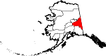
Southeast Fairbanks Census Area, Alaska
Encyclopedia
U.S. state
A U.S. state is any one of the 50 federated states of the United States of America that share sovereignty with the federal government. Because of this shared sovereignty, an American is a citizen both of the federal entity and of his or her state of domicile. Four states use the official title of...
of Alaska
Alaska
Alaska is the largest state in the United States by area. It is situated in the northwest extremity of the North American continent, with Canada to the east, the Arctic Ocean to the north, and the Pacific Ocean to the west and south, with Russia further west across the Bering Strait...
, United States
United States
The United States of America is a federal constitutional republic comprising fifty states and a federal district...
. As of the 2000 census, the population was 6,174. It is part of the unorganized borough
Unorganized Borough
The Unorganized Borough is the part of the U.S. state of Alaska not contained in any of its 18 organized boroughs. It encompasses more than half of Alaska's area, , an area larger than any other US state...
and therefore has no borough seat. Its largest communities are Deltana
Deltana, Alaska
Deltana is a census-designated place in Southeast Fairbanks Census Area, Alaska, United States. At the 2000 census the population was 1,570.-History:...
and Tok
Tok, Alaska
Tok is a census-designated place in Southeast Fairbanks Census Area, Alaska, United States. The population was 1,393 at the 2000 census.-Geography:...
, both unincorporated CDP
Census-designated place
A census-designated place is a concentration of population identified by the United States Census Bureau for statistical purposes. CDPs are delineated for each decennial census as the statistical counterparts of incorporated places such as cities, towns and villages...
s.
Geography
The census area has a total area of 25,061 square miles (64,908 km²), of which, 24,815 square miles (64,270 km²) of it is land and 246 square miles (638 km²) of it (0.98%) is water.Adjacent boroughs and census areas
- Fairbanks North Star Borough, AlaskaFairbanks North Star Borough, Alaska-Demographics:As of the 2000 census, 82,840 people, 29,777 households, and 20,516 families were residing in the borough. The population density was 11 people per square mile . There were 33,291 housing units at an average density of 4 per square mile...
- Northwest - Yukon-Koyukuk Census Area, AlaskaYukon-Koyukuk Census Area, AlaskaYukon-Koyukuk Census Area is a census area located in the state of Alaska, United States. As of the 2010 census, the population was 5,588. It is part of the unorganized borough and therefore has no borough seat...
- North - Valdez-Cordova Census Area, AlaskaValdez-Cordova Census Area, AlaskaValdez-Cordova Census Area is a census area located in the state of Alaska, United States. As of the 2000 census, the population was 10,195. It is part of the unorganized borough and therefore has no borough seat...
- South - Matanuska-Susitna Borough, AlaskaMatanuska-Susitna Borough, Alaska-National protected areas:* Chugach National Forest * Denali National Park and Preserve ** Denali Wilderness * Lake Clark National Park and Preserve ** Lake Clark Wilderness -Demographics:...
- Southwest - Denali Borough, AlaskaDenali Borough, Alaska-Demographics:As of the census of 2000, there were 1,893 people, 785 households, and 452 families residing in the borough. The population density was 0 people per square mile . There were 1,351 housing units at an average density of 0 per square mile...
- West
Also shares eastern border with the Yukon Territory, Canada
Canada
Canada is a North American country consisting of ten provinces and three territories. Located in the northern part of the continent, it extends from the Atlantic Ocean in the east to the Pacific Ocean in the west, and northward into the Arctic Ocean...
.
National protected areaProtected areaProtected areas are locations which receive protection because of their recognised natural, ecological and/or cultural values. There are several kinds of protected areas, which vary by level of protection depending on the enabling laws of each country or the regulations of the international...
s
- Tetlin National Wildlife RefugeTetlin National Wildlife RefugeTetlin National Wildlife Refuge is a dynamic landscape made up of forests, wetlands, tundra, lakes, mountains and glacial rivers bounded by the snowy peaks of the Alaska Range. This upper Tanana River valley has been called the "Tetlin Passage," because it serves as a major migratory route for...
(part) - Wrangell-St. Elias National Park and PreserveWrangell-St. Elias National Park and PreserveWrangell–St. Elias National Park and Preserve is a United States National Park in southeastern Alaska. It was established in 1980 by the Alaska National Interest Lands Conservation Act. The park area is included in an International Biosphere Reserve and is part of a UNESCO World Heritage Site...
(part)- Wrangell-Saint Elias WildernessWrangell-Saint Elias WildernessWrangell-Saint Elias Wilderness is a wilderness area in Alaska, United States. At , it is the largest designated U.S. Wilderness Area, and lies within Wrangell-Saint Elias National Park and Preserve, the largest national park in the United States...
(part)
- Wrangell-Saint Elias Wilderness
- Yukon-Charley Rivers National PreserveYukon-Charley Rivers National PreserveThe Yukon–Charley Rivers National Preserve is located in east central Alaska along the border with Canada. It encompasses 115 miles of the 1,800-mile Yukon River and the entire Charley River basin....
(part)
Demographics
As of the censusCensus
A census is the procedure of systematically acquiring and recording information about the members of a given population. It is a regularly occurring and official count of a particular population. The term is used mostly in connection with national population and housing censuses; other common...
of 2000, there were 6,174 people, 2,098 households, and 1,506 families residing in the census area. The population density
Population density
Population density is a measurement of population per unit area or unit volume. It is frequently applied to living organisms, and particularly to humans...
was 0.25 people per square mile (0.01/km²). There were 3,225 housing units at an average density of 0.13/sq mi (0.05/km²). The racial makeup of the census area was 78.99% White
Race (United States Census)
Race and ethnicity in the United States Census, as defined by the Federal Office of Management and Budget and the United States Census Bureau, are self-identification data items in which residents choose the race or races with which they most closely identify, and indicate whether or not they are...
, 1.98% Black
Race (United States Census)
Race and ethnicity in the United States Census, as defined by the Federal Office of Management and Budget and the United States Census Bureau, are self-identification data items in which residents choose the race or races with which they most closely identify, and indicate whether or not they are...
or African American
Race (United States Census)
Race and ethnicity in the United States Census, as defined by the Federal Office of Management and Budget and the United States Census Bureau, are self-identification data items in which residents choose the race or races with which they most closely identify, and indicate whether or not they are...
, 12.71% Native American
Race (United States Census)
Race and ethnicity in the United States Census, as defined by the Federal Office of Management and Budget and the United States Census Bureau, are self-identification data items in which residents choose the race or races with which they most closely identify, and indicate whether or not they are...
, 0.68% Asian
Race (United States Census)
Race and ethnicity in the United States Census, as defined by the Federal Office of Management and Budget and the United States Census Bureau, are self-identification data items in which residents choose the race or races with which they most closely identify, and indicate whether or not they are...
, 0.15% Pacific Islander
Race (United States Census)
Race and ethnicity in the United States Census, as defined by the Federal Office of Management and Budget and the United States Census Bureau, are self-identification data items in which residents choose the race or races with which they most closely identify, and indicate whether or not they are...
, 0.73% from other races
Race (United States Census)
Race and ethnicity in the United States Census, as defined by the Federal Office of Management and Budget and the United States Census Bureau, are self-identification data items in which residents choose the race or races with which they most closely identify, and indicate whether or not they are...
, and 4.76% from two or more races. 2.70% of the population were Hispanic
Race (United States Census)
Race and ethnicity in the United States Census, as defined by the Federal Office of Management and Budget and the United States Census Bureau, are self-identification data items in which residents choose the race or races with which they most closely identify, and indicate whether or not they are...
or Latino
Race (United States Census)
Race and ethnicity in the United States Census, as defined by the Federal Office of Management and Budget and the United States Census Bureau, are self-identification data items in which residents choose the race or races with which they most closely identify, and indicate whether or not they are...
of any race. 4.29% reported speaking an Athabaskan language at home, while 4.02% speak Russian
Russian language
Russian is a Slavic language used primarily in Russia, Belarus, Uzbekistan, Kazakhstan, Tajikistan and Kyrgyzstan. It is an unofficial but widely spoken language in Ukraine, Moldova, Latvia, Turkmenistan and Estonia and, to a lesser extent, the other countries that were once constituent republics...
, 3.76% Ukrainian
Ukrainian language
Ukrainian is a language of the East Slavic subgroup of the Slavic languages. It is the official state language of Ukraine. Written Ukrainian uses a variant of the Cyrillic alphabet....
, and 2.34% Spanish
Spanish language
Spanish , also known as Castilian , is a Romance language in the Ibero-Romance group that evolved from several languages and dialects in central-northern Iberia around the 9th century and gradually spread with the expansion of the Kingdom of Castile into central and southern Iberia during the...
http://www.mla.org/map_data_results&state_id=2&county_id=240&mode=geographic&zip=&place_id=&cty_id=&ll=&a=&ea=&order=r.
There were 2,098 households out of which 39.40% had children under the age of 18 living with them, 58.20% were married couples
Marriage
Marriage is a social union or legal contract between people that creates kinship. It is an institution in which interpersonal relationships, usually intimate and sexual, are acknowledged in a variety of ways, depending on the culture or subculture in which it is found...
living together, 8.60% had a female householder with no husband present, and 28.20% were non-families. 23.50% of all households were made up of individuals and 5.50% had someone living alone who was 65 years of age or older. The average household size was 2.80 and the average family size was 3.34.
In the census area the population was spread out with 32.80% under the age of 18, 7.60% from 18 to 24, 27.80% from 25 to 44, 25.70% from 45 to 64, and 6.10% who were 65 years of age or older. The median age was 34 years. For every 100 females there were 107.20 males. For every 100 females age 18 and over, there were 108.60 males.
Cities and towns
- Alcan BorderAlcan Border, AlaskaAlcan Border is a census-designated place in the Southeast Fairbanks Census Area in the U.S. state of Alaska. Alcan Border is part of the Unorganized Borough. The population was 21 at the 2000 census.-Location and Climate:...
- Big DeltaBig Delta, AlaskaBig Delta is a census-designated place in Southeast Fairbanks Census Area, Alaska, United States. The population was 749 at the 2000 census...
- ChickenChicken, AlaskaChicken is a census-designated place in Southeast Fairbanks Census Area, Alaska, United States. Chicken is a community founded on gold mining and is one of the few surviving gold rush towns in Alaska...
- Delta JunctionDelta Junction, AlaskaDelta Junction is a city in the Southeast Fairbanks Census Area, Alaska, United States. According to 2005 Census Bureau estimates, the population of the city is 897. The city is located a short distance south of the confluence of the Delta River with the Tanana River, which is at Big Delta...
- DeltanaDeltana, AlaskaDeltana is a census-designated place in Southeast Fairbanks Census Area, Alaska, United States. At the 2000 census the population was 1,570.-History:...
- Dot LakeDot Lake, AlaskaDot Lake is a census-designated place in Southeast Fairbanks Census Area, Alaska, United States. It is located on the Alaska Highway between Delta Junction and Tok...
- Dot Lake VillageDot Lake Village, AlaskaDot Lake Village is a census-designated place in Southeast Fairbanks Census Area, Alaska, United States. The population was 38 at the 2000 census.-Geography:Dot Lake Village is located at ....
- Dry CreekDry Creek, AlaskaDry Creek is a census-designated place in Southeast Fairbanks Census Area, Alaska, United States. At the 2000 census the population was 128.-Geography:Dry Creek is located at ....
- EagleEagle, AlaskaEagle is a city located along the United States-Canada border in the Southeast Fairbanks Census Area, Alaska, United States. It includes Eagle Historic District, a U.S. National Historic Landmark. The population was 129 at the 2000 census...
- Eagle VillageEagle Village, AlaskaEagle Village is a census-designated place in Southeast Fairbanks Census Area, Alaska, United States. The population was 68 at the 2000 census....
- Fort GreelyFort Greely, AlaskaFort Greely is a census-designated place in Southeast Fairbanks Census Area, Alaska, United States. It is home to the Fort Greely military installation. At the 2000 census the population was 461.-Geography:...
- Healy LakeHealy Lake, AlaskaHealy Lake is a census-designated place in Southeast Fairbanks Census Area, Alaska, United States. The population was 37 at the 2000 census.-Geography:Healy Lake is located at ....
- NorthwayNorthway, AlaskaNorthway is a census-designated place in Southeast Fairbanks Census Area, Alaska, United States. The population was 95 at the 2000 census.-Geography:Northway is located at ....
- Northway JunctionNorthway Junction, AlaskaNorthway Junction is a census-designated place in Southeast Fairbanks Census Area, Alaska, United States. The population was 72 at the 2000 census.-Geography:Northway Junction is located at ....
- Northway VillageNorthway Village, AlaskaNorthway Village is a census-designated place in Southeast Fairbanks Census Area, Alaska, United States. The population was 107 at the 2000 census.-Geography:Northway Village is located at ....
- TanacrossTanacross, AlaskaTanacross is a census-designated place in Southeast Fairbanks Census Area, Alaska, United States. At the 2000 census the population was 140...
- TetlinTetlin, AlaskaTetlin is a census-designated place in Southeast Fairbanks Census Area, Alaska, United States. At the 2000 census the population was 117.-Geography:Tetlin is located at ....
- TokTok, AlaskaTok is a census-designated place in Southeast Fairbanks Census Area, Alaska, United States. The population was 1,393 at the 2000 census.-Geography:...