

South Wigston
Encyclopedia
South Wigston is a suburb of Leicester
, England
. It is outside the city boundary, forming part of the Oadby and Wigston
district of Leicestershire
.
, specifically west of the Midland Main Line
. The Crow Mills area has been the site of a grain mill since the 13th century, though the present mill (now a private house) was built later on the original footings. The mill is on the north bank of the River Sence
and backs onto the nearby Grand Union Canal
, which generally forms the southern boundary of South Wigston. The first major development of the area came with the arrival of the Midland Counties Railway
's station, the Midland Railway
's Wigston Junction, goods yard and station and the South Leicestershire Railway
's station. Industrial and residential buildings, the Wesleyan Methodist Church
(1886), Church of England parish church
of Saint Thomas the Apostle (1893), Congregational Church
(1897), Primitive Methodist Church (1900, demolished, now Best Close), the Clarence Hotel (1890, now the Marquess of Queensbury Public House), and the Grand Hotel (circa 1880s, currently unoccupied, incorporates the former Venetia House) were built in the triangle of land between the then Wigston junction to Rugby line
to the east, the Wigston to Nuneaton line
(Leicester to Hinckley
) to the north and Saffron Road to the west. Much of the building work (including both hotels and his former home Venetia House) was commissioned by Orson Wright (circa 1880s).
British Rail
ways closed all three railway stations in the 1960s but Leicestershire County Council
opened a new South Wigston railway station
on the Nuneaton line in 1986. It is served by CrossCountry
trains take to and to .
The musical artist Gertie Gitana
performed at the Clarence Ballroom, and one of its rooms was named after her.
St Thomas the Apostle parish church is a red brick Gothic Revival
building designed by Stockdale Harrison and Sons. Notable local clergy include Bishop Robin Woods
, who was Vicar from 1946 to 1951. St. Thomas's has a strong musical tradition and maintains a 40-strong choir of men and boys.
The land enclosed by the Grand Union Canal, Midland Main Line and former Wigston to Rugby line started to be developed around Lansdowne Grove at the start of the twentieth century with town houses becoming a conservation area
in the late 1980s early 1990s, and later a sizeable council estate, industrial estate and in the 1990s another large housing estate.
South Wigston has seen considerable change in recent times, and there are plans for the future development of the area. Tesco
opened a new supermarket in October 2005 along with a 24-hour petrol station, creating jobs for the local area. Soon after the Kwik Save
supermarket on Blaby Road closed down. Station Street is currently witnessing redevelopment of formerly industrial buildings, now being converted into homes. There are a variety of possible plans for disused factory and warehouse buildings on Canal Street also.
There is also a belief that South Leicestershire College is looking to relocate to Canal Street. There is already a sign erected for the college in the site of the former factories on Blaby Road. It is also believed that the College is also looking to buy the site of The Old Grand Hotel, although the for sale signs on the Grand still suggests it is still for sale.
Previous owners of the large factory between the southern end of Canal Street and the former Leicester – Rugby railway line were Dunmores Biscuits whose large factory chimney dominated the local landscape. They were later taken over by Nabisco
which in turn was bought by United Biscuits
. Further up towards Blaby Road north of the Grand Hotel was Atkinson's hosiery factory which was a major employer in the area for some years after the war as was Dunmores. In Irlam Street opposite the biscuit factory was Morrison Electricars who used to make electrically powered vehicles such as milk float
s. Other notable businesses who were in South Wigston were Premier Percussion
(used to be in Canal Street, now in a modern factory on Blaby Road near the railway bridge), Constone (concrete pipe makers) at Saffron Lane and Marshall's Coal who were in the yard opposite Blaby Road Park.
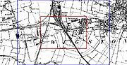
, which runs south of the township, was built 1793—1809, and a house stood by the Countesthorpe Road near the bridges over the river and canal. In 1840 the Midland Counties Railway was built between and ; it ran to the east of where Canal Street stands today. North of Kirkdale Road, the Midland Railway built the south chord of Wigston Junction in 1872.
To the east of the Countesthorpe Road and Canal Street junction was Crow Mill which is recorded on The County Sites and Monuments Register as a medieval windmill. The building was a post mill where the whole structure could be turned into the prevailing wind. The mill survived until the 20th century and is shown as disused on the 1886 Ordnance Survey Map, though it had gone by the second edition of the map in 1914.
 The town of South Wigston was developed in the late 19th century by the owner of a large brickworks. The settlement follows the tradition of establishing 'model' towns set by Victorian philanthropists at places such as New Lanark
and Saltaire
and continued in towns such as Bournville
and Port Sunlight
. Unlike the majority of these other towns however, South Wigston was not just intended to house workers in the brickyard. Other commercial premises, particularly associated with the clothing industry, were established right from the start.
Like model other model settlements such as Saltaire, the street pattern is generally a grid and most of the housing is in terraces. Most of the houses are of similar type (though some were slightly bigger and had front gardens) with just a few larger houses on Orange Street, Blaby Road (until many were converted to shops) and particularly Saffron Road built to house more affluent residents. The clear provision of different sizes and standards of housing to suit different classes of occupiers is not so great as in many model towns.
Although there are differences of detailing between the terraces and groups of houses, the area has a very strong character. The principal reason for this is that the buildings were seemingly all built using bricks from Orson Wright's Wigston Junction Brick Works. The majority of traditional buildings are therefore of red brick with a colour range towards orange and purple, with a few houses of gault brick or with such brick used as detailing. Whilst decorative brickwork is used for the eaves, window and door heads and boundary walls, it is rarely used for the window surrounds and mullions. These appear to have been standard designs in most cases.
In terms of town planning, Blaby Road was the main cross route and was lined by many of the shops and public buildings. Canal Street was the home of most of the industrial and manufacturing concerns and had shops on some street corners and some public buildings especially at the north end. Countesthorpe Road had some industrial uses and public buildings. The schools were all off Bassett Street, whilst housing was generally sited on east – west orientated streets south of Blaby Road and north-south running streets north of Blaby Road. This was presumably to avoid very long streets of terraced properties which might have appeared rather monotonous.
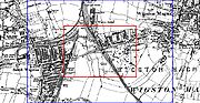
The 1886 Ordnance Survey Map shows the beginnings of the settlement. The brickworks are the largest single premises west of Saffron Road. Blaby Road is the most developed road with three terraces of properties along the south side; one of 25 properties to the east of Countesthorpe Road, one of 18 to the east of Dunton Street and a smaller terrace from the corner of Canal Street to the level crossing and South Wigston station. On the north side of Blaby Road, the only buildings were four terraced properties to the west of Station Street.
Other buildings completed by 1886 included houses on the west side of Glen Gate and Station Street with three buildings on the north side of Kirkdale Road and a block of four houses on the east side of Station Street. South of Blaby Road, there was a long row of seemingly very small cottages on the west side of Countesthorpe Road (where a car park is today) and a block on the north east end of Timber Street which probably had a shop on the corner and a pair of houses fronting Canal Street.
A larger pair faced them on the east side of Canal Street and to the north was a large factory called the Perseverance Works. Countesthorpe Road was the main route to the south and this went under the railway, past Crow Mill and out into open countryside. The line of much of Canal Street, together with the streets north of Timber Street had been laid out, whilst north of Blaby Road two tracks existed though seemingly they were relocated to later become Fairfield and Leopold Streets.
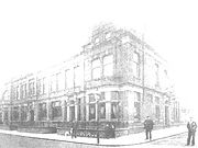 The Duke Of Clarence Hotel was on Blaby Road; this was very much the centre of South Wigston's social life for the first 50 years of the new township.
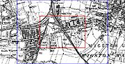
Development continued apace in the next few years and by 1893, many new houses along the streets off Canal Street with some larger houses on Orange Street had been built. Blaby Road continued to be developed for houses, shops and some public buildings as well as the site of Orson Wright's own house, Ashbourne, on the corner of Glen Gate. St Thomas' parish church was built (minus the tower) in 1893 to supersede a tin tabernacle
that continued in service as the Sunday school
until it was replaced in the late 1920s. North of Blaby Road, terraces were built on Leopold Street, Fairfield Street and Glen Gate.
 The settlement developed very quickly and was largely complete by the time Orson Wright died in 1913. Thereafter the main development was the provision of council housing
on the undeveloped sites. Some of this was in terraces, the rest in more typical semi detached forms.
 By 1914 over 600 houses together with more factories, shops, churches and schools had been built. Despite this, vacant lots (or 'greens' as they were popularly known) were a feature of most of the streets in the town and were used as informal play areas. In the late 1920s many of these were built on to provide terraced council houses on Kirkdale Road and some of the surrounding streets with semi-detached houses on several other streets.
 A park was formed beyond the eastern railway line in 1929 as the major amenity land and the biscuit factory developed. The brick works however had ceased production in the early 1930s, though there were still a number of major employers in the area including Toon and Black's Footwear factory on Saffron Road and Morrison the Electric Vehicle Manufacturers who took over Brunswick Mills between Garden and Irlam Streets in the 1930s.
In the later 20th century Orson Wright's house was demolished and replaced by shops, two of the schools off Bassett Street were demolished, Toon and Black's factory redeveloped and virtually the whole block between Irlam and Garden Streets was redeveloped for housing in 2004 to 2005. The biscuit factory on Canal Street has expanded but many of the old industrial concerns, large and small, are now empty or underused.
is accessible from Kenilworth Road the station has services to and .
South Wigston is served by Arriva Midlands (Leicester)
services 47, 48, 49A and 85. Arriva Midlands' Wigston depot is on Station Street.
Leicester
Leicester is a city and unitary authority in the East Midlands of England, and the county town of Leicestershire. The city lies on the River Soar and at the edge of the National Forest...
, England
England
England is a country that is part of the United Kingdom. It shares land borders with Scotland to the north and Wales to the west; the Irish Sea is to the north west, the Celtic Sea to the south west, with the North Sea to the east and the English Channel to the south separating it from continental...
. It is outside the city boundary, forming part of the Oadby and Wigston
Oadby and Wigston
Oadby and Wigston is a local government district and borough in the English county of Leicestershire.-Geography:It is composed of the areas of Oadby, Wigston Magna and South Wigston. It is predominantly urban, and runs directly into Leicester, to the north-west...
district of Leicestershire
Leicestershire
Leicestershire is a landlocked county in the English Midlands. It takes its name from the heavily populated City of Leicester, traditionally its administrative centre, although the City of Leicester unitary authority is today administered separately from the rest of Leicestershire...
.
Geography and administration
South Wigston is west of Wigston MagnaWigston Magna
Wigston Magna also historically referred to as Wigston Two Steeples or Great Wigston , is a town within Leicestershire, England just to the south of Leicester, on the A5199 road which leads to Northampton....
, specifically west of the Midland Main Line
Midland Main Line
The Midland Main Line is a major railway route in the United Kingdom, part of the British railway system.The present-day line links London St...
. The Crow Mills area has been the site of a grain mill since the 13th century, though the present mill (now a private house) was built later on the original footings. The mill is on the north bank of the River Sence
River Sence
The River Sence is a river in Leicestershire, England. The tributaries of the Sence including the Saint and Tweed fan out over much of western Leicestershire from Charnwood Forest and Coalville in the north-east to Hinckley and almost to Watling Street in the south and south-west...
and backs onto the nearby Grand Union Canal
Grand Union Canal (old)
The Grand Union Canal was a canal in England from Foxton, Leicestershire on the Leicester and Northampton canal to Buckby on the Grand Junction Canal...
, which generally forms the southern boundary of South Wigston. The first major development of the area came with the arrival of the Midland Counties Railway
Midland Counties Railway
The Midland Counties Railway was a railway company in the United Kingdom which existed between 1832 and 1844, connecting Nottingham, Leicester and Derby with Rugby and thence, via the London and Birmingham Railway, to London. The MCR system connected with the North Midland Railway and the...
's station, the Midland Railway
Midland Railway
The Midland Railway was a railway company in the United Kingdom from 1844 to 1922, when it became part of the London, Midland and Scottish Railway....
's Wigston Junction, goods yard and station and the South Leicestershire Railway
South Leicestershire Railway
The South Leicestershire Railway was founded in 1850 as the Nuneaton and Hinckley Railway, with Parliamentary powers to build a railway from on the London and North Western Railway to in Leicestershire. In 1860 Parliament authorised the company to extend its line to Wigston Junction on the...
's station. Industrial and residential buildings, the Wesleyan Methodist Church
Wesleyan Methodist Church (Great Britain)
The Wesleyan Methodist Church was the name used by the major Methodist movement in Great Britain following its split from the Church of England after the death of John Wesley and the appearance of parallel Methodist movements...
(1886), Church of England parish church
Church of England parish church
A parish church in the Church of England is the church which acts as the religious centre for the people within the smallest and most basic Church of England administrative region, known as a parish.-Parishes in England:...
of Saint Thomas the Apostle (1893), Congregational Church
United Reformed Church
The United Reformed Church is a Christian church in the United Kingdom. It has approximately 68,000 members in 1,500 congregations with some 700 ministers.-Origins and history:...
(1897), Primitive Methodist Church (1900, demolished, now Best Close), the Clarence Hotel (1890, now the Marquess of Queensbury Public House), and the Grand Hotel (circa 1880s, currently unoccupied, incorporates the former Venetia House) were built in the triangle of land between the then Wigston junction to Rugby line
Midland Counties Railway
The Midland Counties Railway was a railway company in the United Kingdom which existed between 1832 and 1844, connecting Nottingham, Leicester and Derby with Rugby and thence, via the London and Birmingham Railway, to London. The MCR system connected with the North Midland Railway and the...
to the east, the Wigston to Nuneaton line
South Leicestershire Railway
The South Leicestershire Railway was founded in 1850 as the Nuneaton and Hinckley Railway, with Parliamentary powers to build a railway from on the London and North Western Railway to in Leicestershire. In 1860 Parliament authorised the company to extend its line to Wigston Junction on the...
(Leicester to Hinckley
Birmingham to Peterborough Line
The Birmingham to Peterborough Line is a cross-country railway line in the United Kingdom, linking Birmingham to Peterborough, via Nuneaton and Leicester....
) to the north and Saffron Road to the west. Much of the building work (including both hotels and his former home Venetia House) was commissioned by Orson Wright (circa 1880s).
British Rail
British Rail
British Railways , which from 1965 traded as British Rail, was the operator of most of the rail transport in Great Britain between 1948 and 1997. It was formed from the nationalisation of the "Big Four" British railway companies and lasted until the gradual privatisation of British Rail, in stages...
ways closed all three railway stations in the 1960s but Leicestershire County Council
Leicestershire County Council
Leicestershire County Council is the county council for the English non-metropolitan county of Leicestershire. It was originally formed in 1889 by the Local Government Act 1888. The county is divided into 52 electoral divisions, which return a total of 55 councillors. The council is controlled by...
opened a new South Wigston railway station
South Wigston railway station
South Wigston railway station is a railway station serving the suburb of South Wigston, Leicester, England. The station is on the Birmingham to Peterborough Line about south of . South Wigston station is owned by Network Rail and managed by East Midlands Trains Train Operating Company...
on the Nuneaton line in 1986. It is served by CrossCountry
CrossCountry
CrossCountry is the brand name of XC Trains Ltd., a British train operating company owned by Arriva...
trains take to and to .
The musical artist Gertie Gitana
Gertie Gitana
Gertie Gitana , was a British music hall entertainer.She was born Gertrude Mary Astbury in Shirley Street, Longport, Stoke-on-Trent. Her father was a pottery works foreman and her mother Lavinia taught at St Peter's RC school in Cobridge...
performed at the Clarence Ballroom, and one of its rooms was named after her.
St Thomas the Apostle parish church is a red brick Gothic Revival
Gothic Revival architecture
The Gothic Revival is an architectural movement that began in the 1740s in England...
building designed by Stockdale Harrison and Sons. Notable local clergy include Bishop Robin Woods
Robin Woods
Robert Wilmer Woods, KCMG, KCVO, always called Robin Woods, was an English Anglican divine, Dean of Windsor and Bishop of Worcester.-Background and education:...
, who was Vicar from 1946 to 1951. St. Thomas's has a strong musical tradition and maintains a 40-strong choir of men and boys.
The land enclosed by the Grand Union Canal, Midland Main Line and former Wigston to Rugby line started to be developed around Lansdowne Grove at the start of the twentieth century with town houses becoming a conservation area
Conservation Area (United Kingdom)
In the United Kingdom, the term Conservation Area nearly always applies to an area considered worthy of preservation or enhancement because of its special architectural or historic interest, "the character or appearance of which it is desirable to preserve or enhance," as required by the Planning ...
in the late 1980s early 1990s, and later a sizeable council estate, industrial estate and in the 1990s another large housing estate.
South Wigston has seen considerable change in recent times, and there are plans for the future development of the area. Tesco
Tesco
Tesco plc is a global grocery and general merchandise retailer headquartered in Cheshunt, United Kingdom. It is the third-largest retailer in the world measured by revenues and the second-largest measured by profits...
opened a new supermarket in October 2005 along with a 24-hour petrol station, creating jobs for the local area. Soon after the Kwik Save
Kwik Save
Kwik Save was a discount supermarket chain in the United Kingdom until 2007. Its stores were small to medium sized high street supermarkets, mainly located in areas with below average incomes...
supermarket on Blaby Road closed down. Station Street is currently witnessing redevelopment of formerly industrial buildings, now being converted into homes. There are a variety of possible plans for disused factory and warehouse buildings on Canal Street also.
There is also a belief that South Leicestershire College is looking to relocate to Canal Street. There is already a sign erected for the college in the site of the former factories on Blaby Road. It is also believed that the College is also looking to buy the site of The Old Grand Hotel, although the for sale signs on the Grand still suggests it is still for sale.
Previous owners of the large factory between the southern end of Canal Street and the former Leicester – Rugby railway line were Dunmores Biscuits whose large factory chimney dominated the local landscape. They were later taken over by Nabisco
Nabisco
Nabisco is an American brand of cookies and snacks. Headquartered in East Hanover, New Jersey, the company is a subsidiary of Illinois-based Kraft Foods. Nabisco's plant in Chicago, a production facility at 7300 S...
which in turn was bought by United Biscuits
United Biscuits
__FORCETOC__United Biscuits is a British multinational food manufacturer, makers of the BN biscuits, McVitie's biscuits, KP Nuts, Hula Hoops, The Real McCoy's crisps, Phileas Fogg snacks, Jacob's Cream Crackers, and Twiglets...
. Further up towards Blaby Road north of the Grand Hotel was Atkinson's hosiery factory which was a major employer in the area for some years after the war as was Dunmores. In Irlam Street opposite the biscuit factory was Morrison Electricars who used to make electrically powered vehicles such as milk float
Milk float
A milk float is a battery electric vehicle , specifically designed for the delivery of fresh milk. They were once common in many European countries, particularly the United Kingdom, and were operated by local dairies...
s. Other notable businesses who were in South Wigston were Premier Percussion
Premier Percussion
Premier Percussion Limited is an English manufacturer of drums and percussion instruments.The company was founded in 1922 as the Premier Drum Company by London drummer Albert Della Porta and drum builder George Smith...
(used to be in Canal Street, now in a modern factory on Blaby Road near the railway bridge), Constone (concrete pipe makers) at Saffron Lane and Marshall's Coal who were in the yard opposite Blaby Road Park.
History
Before the establishment of South Wigston in 1883, the area was largely open fields. The Leicestershire and Northamptonshire Union CanalLeicestershire and Northamptonshire Union Canal
The Leicestershire and Northamptonshire Union Canal is a canal in England that is now part of the Grand Union Canal.It was authorised by an Act of Parliament in 1793 to connect Leicester to the Nene near Northampton and to join the projected line of the Grand Junction Canal but by 1809 the canal...
, which runs south of the township, was built 1793—1809, and a house stood by the Countesthorpe Road near the bridges over the river and canal. In 1840 the Midland Counties Railway was built between and ; it ran to the east of where Canal Street stands today. North of Kirkdale Road, the Midland Railway built the south chord of Wigston Junction in 1872.
To the east of the Countesthorpe Road and Canal Street junction was Crow Mill which is recorded on The County Sites and Monuments Register as a medieval windmill. The building was a post mill where the whole structure could be turned into the prevailing wind. The mill survived until the 20th century and is shown as disused on the 1886 Ordnance Survey Map, though it had gone by the second edition of the map in 1914.
New Lanark
New Lanark is a village on the River Clyde, approximately 1.4 miles from Lanark, in South Lanarkshire, Scotland. It was founded in 1786 by David Dale, who built cotton mills and housing for the mill workers. Dale built the mills there to take advantage of the water power provided by the river...
and Saltaire
Saltaire
Saltaire is a Victorian model village within the City of Bradford Metropolitan District, West Yorkshire, England, by the River Aire and the Leeds and Liverpool Canal...
and continued in towns such as Bournville
Bournville
Bournville is a model village on the south side of Birmingham, England, best known for its connections with the Cadbury family and chocolate – including a dark chocolate bar branded "Bournville". It is also a ward within the council constituency of Selly Oak and home to the Bournville Centre...
and Port Sunlight
Port Sunlight
Port Sunlight is a model village, suburb and electoral ward in the Metropolitan Borough of Wirral, Merseyside, England. It is located between Lower Bebington and New Ferry, on the Wirral Peninsula. Between 1894 and 1974 it formed part of Bebington urban district within the county of Cheshire...
. Unlike the majority of these other towns however, South Wigston was not just intended to house workers in the brickyard. Other commercial premises, particularly associated with the clothing industry, were established right from the start.
Like model other model settlements such as Saltaire, the street pattern is generally a grid and most of the housing is in terraces. Most of the houses are of similar type (though some were slightly bigger and had front gardens) with just a few larger houses on Orange Street, Blaby Road (until many were converted to shops) and particularly Saffron Road built to house more affluent residents. The clear provision of different sizes and standards of housing to suit different classes of occupiers is not so great as in many model towns.
Although there are differences of detailing between the terraces and groups of houses, the area has a very strong character. The principal reason for this is that the buildings were seemingly all built using bricks from Orson Wright's Wigston Junction Brick Works. The majority of traditional buildings are therefore of red brick with a colour range towards orange and purple, with a few houses of gault brick or with such brick used as detailing. Whilst decorative brickwork is used for the eaves, window and door heads and boundary walls, it is rarely used for the window surrounds and mullions. These appear to have been standard designs in most cases.
In terms of town planning, Blaby Road was the main cross route and was lined by many of the shops and public buildings. Canal Street was the home of most of the industrial and manufacturing concerns and had shops on some street corners and some public buildings especially at the north end. Countesthorpe Road had some industrial uses and public buildings. The schools were all off Bassett Street, whilst housing was generally sited on east – west orientated streets south of Blaby Road and north-south running streets north of Blaby Road. This was presumably to avoid very long streets of terraced properties which might have appeared rather monotonous.
The 1886 Ordnance Survey Map shows the beginnings of the settlement. The brickworks are the largest single premises west of Saffron Road. Blaby Road is the most developed road with three terraces of properties along the south side; one of 25 properties to the east of Countesthorpe Road, one of 18 to the east of Dunton Street and a smaller terrace from the corner of Canal Street to the level crossing and South Wigston station. On the north side of Blaby Road, the only buildings were four terraced properties to the west of Station Street.
Other buildings completed by 1886 included houses on the west side of Glen Gate and Station Street with three buildings on the north side of Kirkdale Road and a block of four houses on the east side of Station Street. South of Blaby Road, there was a long row of seemingly very small cottages on the west side of Countesthorpe Road (where a car park is today) and a block on the north east end of Timber Street which probably had a shop on the corner and a pair of houses fronting Canal Street.
A larger pair faced them on the east side of Canal Street and to the north was a large factory called the Perseverance Works. Countesthorpe Road was the main route to the south and this went under the railway, past Crow Mill and out into open countryside. The line of much of Canal Street, together with the streets north of Timber Street had been laid out, whilst north of Blaby Road two tracks existed though seemingly they were relocated to later become Fairfield and Leopold Streets.
Development continued apace in the next few years and by 1893, many new houses along the streets off Canal Street with some larger houses on Orange Street had been built. Blaby Road continued to be developed for houses, shops and some public buildings as well as the site of Orson Wright's own house, Ashbourne, on the corner of Glen Gate. St Thomas' parish church was built (minus the tower) in 1893 to supersede a tin tabernacle
Tin tabernacle
Tin tabernacles were a type of prefabricated building made from corrugated iron developed in the mid 19th century initially in Great Britain. Corrugated iron was first used for roofing in London in 1829 by Henry Robinson Palmer and the patent sold to Richard Walker who advertised "portable...
that continued in service as the Sunday school
Sunday school
Sunday school is the generic name for many different types of religious education pursued on Sundays by various denominations.-England:The first Sunday school may have been opened in 1751 in St. Mary's Church, Nottingham. Another early start was made by Hannah Ball, a native of High Wycombe in...
until it was replaced in the late 1920s. North of Blaby Road, terraces were built on Leopold Street, Fairfield Street and Glen Gate.
Council house
A council house, otherwise known as a local authority house, is a form of public or social housing. The term is used primarily in the United Kingdom and the Republic of Ireland. Council houses were built and operated by local councils to supply uncrowded, well-built homes on secure tenancies at...
on the undeveloped sites. Some of this was in terraces, the rest in more typical semi detached forms.
In the later 20th century Orson Wright's house was demolished and replaced by shops, two of the schools off Bassett Street were demolished, Toon and Black's factory redeveloped and virtually the whole block between Irlam and Garden Streets was redeveloped for housing in 2004 to 2005. The biscuit factory on Canal Street has expanded but many of the old industrial concerns, large and small, are now empty or underused.
Transport
South Wigston railway stationSouth Wigston railway station
South Wigston railway station is a railway station serving the suburb of South Wigston, Leicester, England. The station is on the Birmingham to Peterborough Line about south of . South Wigston station is owned by Network Rail and managed by East Midlands Trains Train Operating Company...
is accessible from Kenilworth Road the station has services to and .
South Wigston is served by Arriva Midlands (Leicester)
Arriva Fox County
Arriva Leicester is a bus company operating in Leicester and Leicestershire. It is part of Arriva Midlands.-History:Arriva Leicester was formed in 1981, as Midland Red East with the breakup of the old Midland Red bus company, and then became known as Midland Fox in 1984.In September 1996 the...
services 47, 48, 49A and 85. Arriva Midlands' Wigston depot is on Station Street.