

South Dakota Highway 87
Encyclopedia
South Dakota Highway 87 is a highway running through the Black Hills
of the U.S. state
of South Dakota
. The road's northern terminus is U.S. Route 16
and U.S. Route 385 about 3 miles (4.8 km) south of Hill City
. The road's southern terminus is U.S. Route 385 about 6 miles (9.7 km) east of Pringle, South Dakota
, or 14 miles (22.5 km) north of Hot Springs
.
The highway passes through Custer State Park
and Wind Cave National Park
. The northern 14 miles (22.5 km) of the highway is also known as the Needles Highway. The Needles Highway, along with the US 16A concurrency, are also part of the Peter Norbeck Scenic Byway
. Portions of the highway are also a section of Custer State Park's Wildlife Loop.
, east of Pringle
and west of the park headquarters. North of US 385, the route crosses Cold Spring Creek and provides access to the upstream Lake Norbeck, named after Senator Peter Norbeck
, instrumental in establishing several of the national and state parks in the Black Hills. From the start, SD 87 is a very twisting and winding route, with a 180° hairpin turn
a mere half-mile (0.8 km) from the southern terminus. This results in the route taking a westerly tack, though it eventually turns back north and crosses Beaver Creek. Three miles (4.8 km) into the route, it bridges itself and executes a 270° turn.
The route enters Custer State Park
7.151 miles (11.5 km) north of US 385. Admission to the park requires an entrance license; , the fee is $6 per person, or $15 per vehicle. Highway 87 then becomes part of the park's Wildlife Loop, and runs through the town of Blue Bell.
At milepost 17.180 (27.649 km), Highway 87 intersects U.S. Route 16A. From this point onward, the road is part of the Peter Norbeck Scenic Byway. The two routes form a concurrency
and proceed east, passing Legion Lake. The roads split after just under 1.5 miles (2.4 km).
 After splitting from US 16A, the route is known as the Needles Highway. The highway is named after the high granite
"needles
" it winds among. Along this stretch lies the Black Hills Playhouse
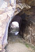
. The highway passes through two tunnels blasted through sheer granite walls—Iron Creek Tunnel at mile 25 (40 km), and Needles Eye Tunnel at mile 31 (50 km). Owing to the narrow roadway, sharp turns, and low tunnels, the road has very little traffic. The vehicles that do travel this road are almost exclusively sightseers.
Just after Needles Eye Tunnel, Highway 87 serves as the northern terminus of SD 89
. After this junction, SD 87 has one more tunnel, Hood Tunnel, at milepost 33 (53 km). It then provides access to the Sylvan Lake Resort. The route finally ends at US 16/385 south of Hill City
.
Black Hills
The Black Hills are a small, isolated mountain range rising from the Great Plains of North America in western South Dakota and extending into Wyoming, USA. Set off from the main body of the Rocky Mountains, the region is something of a geological anomaly—accurately described as an "island of...
of the U.S. state
U.S. state
A U.S. state is any one of the 50 federated states of the United States of America that share sovereignty with the federal government. Because of this shared sovereignty, an American is a citizen both of the federal entity and of his or her state of domicile. Four states use the official title of...
of South Dakota
South Dakota
South Dakota is a state located in the Midwestern region of the United States. It is named after the Lakota and Dakota Sioux American Indian tribes. Once a part of Dakota Territory, South Dakota became a state on November 2, 1889. The state has an area of and an estimated population of just over...
. The road's northern terminus is U.S. Route 16
U.S. Route 16
U.S. Route 16 is an east–west United States Highway between Rapid City, South Dakota and Yellowstone National Park in Wyoming....
and U.S. Route 385 about 3 miles (4.8 km) south of Hill City
Hill City, South Dakota
Hill City is the oldest existing city in Pennington County, South Dakota, United States. The population was 948 at the 2010 census. Hill City is located southwest of Rapid City on State Highway 16 and on U.S. Route 385 that connects Deadwood to Hot Springs...
. The road's southern terminus is U.S. Route 385 about 6 miles (9.7 km) east of Pringle, South Dakota
Pringle, South Dakota
Pringle is a town in Custer County, South Dakota, United States. The population was 112 at the 2010 census.-Geography:Pringle is located at ....
, or 14 miles (22.5 km) north of Hot Springs
Hot Springs, South Dakota
Hot Springs is a city in Fall River County, South Dakota, United States. As of the 2010 census, the city population was 3,711. It is the county seat of Fall River County...
.
The highway passes through Custer State Park
Custer State Park
Custer State Park is a state park and wildlife reserve in the Black Hills of southwestern South Dakota, USA. The park is South Dakota's largest and first state park, named after Lt...
and Wind Cave National Park
Wind Cave National Park
Wind Cave National Park is a United States national park north of the town of Hot Springs in western South Dakota. Established in 1903 by President Theodore Roosevelt, it was the seventh U.S. National Park and the first cave to be designated a national park anywhere in the world. The cave is...
. The northern 14 miles (22.5 km) of the highway is also known as the Needles Highway. The Needles Highway, along with the US 16A concurrency, are also part of the Peter Norbeck Scenic Byway
Peter Norbeck Scenic Byway
The Peter Norbeck Scenic Byway is a National Scenic Byway in the Black Hills National Forest in South Dakota, USA. It is a loop which is composed of portions of U.S. Route 16A, South Dakota Highway 244, South Dakota Highway 87, and South Dakota Highway 89. Parts of the byway enter Black Hills...
. Portions of the highway are also a section of Custer State Park's Wildlife Loop.
Route description
Because of the highway's mountainous, curving nature, it is closed during the winter.South of US 16A
Highway 87 begins at US 385 in Wind Cave National ParkWind Cave National Park
Wind Cave National Park is a United States national park north of the town of Hot Springs in western South Dakota. Established in 1903 by President Theodore Roosevelt, it was the seventh U.S. National Park and the first cave to be designated a national park anywhere in the world. The cave is...
, east of Pringle
Pringle, South Dakota
Pringle is a town in Custer County, South Dakota, United States. The population was 112 at the 2010 census.-Geography:Pringle is located at ....
and west of the park headquarters. North of US 385, the route crosses Cold Spring Creek and provides access to the upstream Lake Norbeck, named after Senator Peter Norbeck
Peter Norbeck
Peter Norbeck served as the ninth Governor of South Dakota, and as a United States Senator. Norbeck was the first Governor of South Dakota to have been born within the borders of the state.-Biography:...
, instrumental in establishing several of the national and state parks in the Black Hills. From the start, SD 87 is a very twisting and winding route, with a 180° hairpin turn
Hairpin turn
A hairpin turn , named for its resemblance to a hairpin/bobby pin, is a bend in a road with a very acute inner angle, making it necessary for an oncoming vehicle to turn almost 180° to continue on the road. Such turns in ramps and trails may be called switchbacks in American English, by analogy...
a mere half-mile (0.8 km) from the southern terminus. This results in the route taking a westerly tack, though it eventually turns back north and crosses Beaver Creek. Three miles (4.8 km) into the route, it bridges itself and executes a 270° turn.
The route enters Custer State Park
Custer State Park
Custer State Park is a state park and wildlife reserve in the Black Hills of southwestern South Dakota, USA. The park is South Dakota's largest and first state park, named after Lt...
7.151 miles (11.5 km) north of US 385. Admission to the park requires an entrance license; , the fee is $6 per person, or $15 per vehicle. Highway 87 then becomes part of the park's Wildlife Loop, and runs through the town of Blue Bell.
At milepost 17.180 (27.649 km), Highway 87 intersects U.S. Route 16A. From this point onward, the road is part of the Peter Norbeck Scenic Byway. The two routes form a concurrency
Concurrency (road)
A concurrency, overlap, or coincidence in a road network is an instance of one physical road bearing two or more different highway, motorway, or other route numbers...
and proceed east, passing Legion Lake. The roads split after just under 1.5 miles (2.4 km).
Needles Highway
Granite
Granite is a common and widely occurring type of intrusive, felsic, igneous rock. Granite usually has a medium- to coarse-grained texture. Occasionally some individual crystals are larger than the groundmass, in which case the texture is known as porphyritic. A granitic rock with a porphyritic...
"needles
Needles (Black Hills)
The Needles of the Black Hills of South Dakota are a region of fantastically eroded granite pillars, towers, and spires. Popular with rock climbers and tourists alike, the Needles are accessed from the Needles Highway, which is a part of Sylvan Lake Road...
" it winds among. Along this stretch lies the Black Hills Playhouse
Black Hills Playhouse
The Black Hills Playhouse is an American theater located just off the Needles Highway and Iron Mountain Road in Custer State Park in the Black Hills of South Dakota. The playhouse is managed by Black Hills Playhouse Inc. It is one of the oldest continuously operated summer stock theaters in...
. The highway passes through two tunnels blasted through sheer granite walls—Iron Creek Tunnel at mile 25 (40 km), and Needles Eye Tunnel at mile 31 (50 km). Owing to the narrow roadway, sharp turns, and low tunnels, the road has very little traffic. The vehicles that do travel this road are almost exclusively sightseers.
Just after Needles Eye Tunnel, Highway 87 serves as the northern terminus of SD 89
South Dakota Highway 89
South Dakota Highway 89 is a state highway in southwest South Dakota. The highway is long and runs from U.S. Route 18 near Minnekahta to South Dakota Highway 87 in Custer State Park. SD 89 is co-signed with U.S. Route 385 from Pringle to Custer...
. After this junction, SD 87 has one more tunnel, Hood Tunnel, at milepost 33 (53 km). It then provides access to the Sylvan Lake Resort. The route finally ends at US 16/385 south of Hill City
Hill City, South Dakota
Hill City is the oldest existing city in Pennington County, South Dakota, United States. The population was 948 at the 2010 census. Hill City is located southwest of Rapid City on State Highway 16 and on U.S. Route 385 that connects Deadwood to Hot Springs...
.