
Socastee, South Carolina
Encyclopedia
Socastee is a census-designated place
(CDP) in Horry County
, South Carolina
, United States
. The population was 14,295 at the 2000 census.
was listed in the National Register of Historic Places in 2002.
According to the United States Census Bureau
, the CDP has a total area of 13.9 square miles (36.0 km²), of which, 13.4 square miles (34.6 km²) of it is land and 0.5 square miles (1.4 km²) of it (3.81%) is water.
of 2000, there were 14,295 people, 5,593 households, and 3,820 families residing in the CDP. The population density
was 1,069.1 people per square mile (412.8/km²). There were 6,356 housing units at an average density of 475.4 per square mile (183.6/km²). The racial makeup of the CDP was 86.81% White, 7.01% African American, 0.35% Native American, 2.10% Asian, 0.13% Pacific Islander, 2.01% from other races
, and 1.59% from two or more races. Hispanic or Latino of any race were 4.66% of the population.
There were 5,593 households out of which 33.1% had children under the age of 18 living with them, 52.4% were married couples
living together, 11.3% had a female householder with no husband present, and 31.7% were non-families. 22.7% of all households were made up of individuals and 4.6% had someone living alone who was 65 years of age or older. The average household size was 2.54 and the average family size was 2.97.
In the CDP the population was spread out with 24.3% under the age of 18, 9.7% from 18 to 24, 34.9% from 25 to 44, 22.7% from 45 to 64, and 8.4% who were 65 years of age or older. The median age was 34 years. For every 100 females there were 102.0 males. For every 100 females age 18 and over, there were 101.4 males.
The median income for a household in the CDP was $40,436, and the median income for a family was $45,994. Males had a median income of $28,845 versus $21,782 for females. The per capita income
for the CDP was $18,069. About 5.6% of families and 9.3% of the population were below the poverty line, including 13.7% of those under age 18 and 7.8% of those age 65 or over.
Census-designated place
A census-designated place is a concentration of population identified by the United States Census Bureau for statistical purposes. CDPs are delineated for each decennial census as the statistical counterparts of incorporated places such as cities, towns and villages...
(CDP) in Horry County
Horry County, South Carolina
Horry County is a county located in the U.S. state of South Carolina. This name honored Revolutionary War Hero, Peter Horry. Brigadier General Horry was born in South Carolina sometime around 1743 and started his distinguished military career in 1775 as one of 20 captains the Provincial Congress...
, South Carolina
South Carolina
South Carolina is a state in the Deep South of the United States that borders Georgia to the south, North Carolina to the north, and the Atlantic Ocean to the east. Originally part of the Province of Carolina, the Province of South Carolina was one of the 13 colonies that declared independence...
, United States
United States
The United States of America is a federal constitutional republic comprising fifty states and a federal district...
. The population was 14,295 at the 2000 census.
History
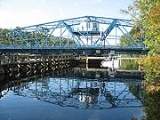
Socastee is a Native American name referred to as "Sawkastee" in a 1711 land grant to Percival Pawley. A skirmish between small forces of American and British troops occurred near Socastee Creek in 1781. By the 1870s, the Socastee community was a significant center for the production and distribution of naval stores such as turpentine and tar. This area included a saw mill, turpentine distilleries, cotton gin, grist mill, cooper shop and general store. The Socastee Historic DistrictSocastee Historic District
The Socastee Historic District, located on the Intracoastal Waterway in Socastee, South Carolina, was added to the National Register of Historic Places in 2002.It includes three contributing buildings, one contributing site, and one contributing structure...
was listed in the National Register of Historic Places in 2002.
Geography
Socastee is located at 33°41′10"N 78°59′33"W (33.686244, -78.992588).According to the United States Census Bureau
United States Census Bureau
The United States Census Bureau is the government agency that is responsible for the United States Census. It also gathers other national demographic and economic data...
, the CDP has a total area of 13.9 square miles (36.0 km²), of which, 13.4 square miles (34.6 km²) of it is land and 0.5 square miles (1.4 km²) of it (3.81%) is water.
Demographics
As of the censusCensus
A census is the procedure of systematically acquiring and recording information about the members of a given population. It is a regularly occurring and official count of a particular population. The term is used mostly in connection with national population and housing censuses; other common...
of 2000, there were 14,295 people, 5,593 households, and 3,820 families residing in the CDP. The population density
Population density
Population density is a measurement of population per unit area or unit volume. It is frequently applied to living organisms, and particularly to humans...
was 1,069.1 people per square mile (412.8/km²). There were 6,356 housing units at an average density of 475.4 per square mile (183.6/km²). The racial makeup of the CDP was 86.81% White, 7.01% African American, 0.35% Native American, 2.10% Asian, 0.13% Pacific Islander, 2.01% from other races
Race (United States Census)
Race and ethnicity in the United States Census, as defined by the Federal Office of Management and Budget and the United States Census Bureau, are self-identification data items in which residents choose the race or races with which they most closely identify, and indicate whether or not they are...
, and 1.59% from two or more races. Hispanic or Latino of any race were 4.66% of the population.
There were 5,593 households out of which 33.1% had children under the age of 18 living with them, 52.4% were married couples
Marriage
Marriage is a social union or legal contract between people that creates kinship. It is an institution in which interpersonal relationships, usually intimate and sexual, are acknowledged in a variety of ways, depending on the culture or subculture in which it is found...
living together, 11.3% had a female householder with no husband present, and 31.7% were non-families. 22.7% of all households were made up of individuals and 4.6% had someone living alone who was 65 years of age or older. The average household size was 2.54 and the average family size was 2.97.
In the CDP the population was spread out with 24.3% under the age of 18, 9.7% from 18 to 24, 34.9% from 25 to 44, 22.7% from 45 to 64, and 8.4% who were 65 years of age or older. The median age was 34 years. For every 100 females there were 102.0 males. For every 100 females age 18 and over, there were 101.4 males.
The median income for a household in the CDP was $40,436, and the median income for a family was $45,994. Males had a median income of $28,845 versus $21,782 for females. The per capita income
Per capita income
Per capita income or income per person is a measure of mean income within an economic aggregate, such as a country or city. It is calculated by taking a measure of all sources of income in the aggregate and dividing it by the total population...
for the CDP was $18,069. About 5.6% of families and 9.3% of the population were below the poverty line, including 13.7% of those under age 18 and 7.8% of those age 65 or over.