

Socastee Historic District
Encyclopedia
The Socastee Historic District, located on the Intracoastal Waterway
in Socastee, South Carolina
, was added to the National Register of Historic Places
in 2002.
It includes three contributing buildings, one contributing site, and one contributing structure. They are a metal swing bridge, two houses, one store and a pecan grove and is one of the few remaining intact examples of post-Civil War
development.
 Samuel Sarvis built his house in 1881, shortly before he was to be married.
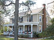 The Thomas B. Cooper house was built for Mr. Cooper by Robert M. Prince, Jr. in 1908.
The exterior has recently been renovated.
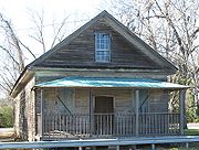 The store was built in 1905 and closed in 1932.
 The Socastee swing bridge was opened 1936. It is 217 feet in
length and 24 feet wide. Originally, the bridge had to be turned by hand and the gatekeeper
worked from the house at the top of the bridge. The first operator of the bridge boarded at the Thomas B. Cooper house.
Watch a video of Socastee swing bridge.
The Socastee turn bridge from the time of its construction was the only means other than previously to ferry across the Intra Coastal waterway. Located on Hwy 544,it was to be closed after approval of a new bridge that was being built on the south of the Socastee bridge.
Though the new bridge solved much of the traffic problems associated to the tourist season, it did not help the locals, and would have created many problems to the residents of Socastee,whom required access to Forestbrook Rd, which is located approximatelt 0.2 miles on the right off Hwy 544 west of the Socastee turn bridge. Additionally Peach Tree Rd was located just 0.1 miles to the left off Hwy 544 west of the waterway. It is this reasoning as to why the Socastee turn bridge has been listed as a Historical Landmark, not only for its Historical value, but also for the interest of the locals of which still currently travel across the Socastee turn bridge in their daily commutes.
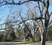 Old pecan grove near the Thomas B. Cooper store.
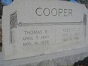 Thomas B. Cooper was the Socastee postmaster in 1908.
Intracoastal Waterway
The Intracoastal Waterway is a 3,000-mile waterway along the Atlantic and Gulf coasts of the United States. Some lengths consist of natural inlets, salt-water rivers, bays, and sounds; others are artificial canals...
in Socastee, South Carolina
Socastee, South Carolina
Socastee is a census-designated place in Horry County, South Carolina, United States. The population was 14,295 at the 2000 census.-History:...
, was added to the National Register of Historic Places
National Register of Historic Places
The National Register of Historic Places is the United States government's official list of districts, sites, buildings, structures, and objects deemed worthy of preservation...
in 2002.
It includes three contributing buildings, one contributing site, and one contributing structure. They are a metal swing bridge, two houses, one store and a pecan grove and is one of the few remaining intact examples of post-Civil War
American Civil War
The American Civil War was a civil war fought in the United States of America. In response to the election of Abraham Lincoln as President of the United States, 11 southern slave states declared their secession from the United States and formed the Confederate States of America ; the other 25...
development.
Samuel S. Sarvis House
Thomas B. Cooper House
The exterior has recently been renovated.
Thomas B. Cooper Store
Swing Bridge
length and 24 feet wide. Originally, the bridge had to be turned by hand and the gatekeeper
worked from the house at the top of the bridge. The first operator of the bridge boarded at the Thomas B. Cooper house.
Watch a video of Socastee swing bridge.
The Socastee turn bridge from the time of its construction was the only means other than previously to ferry across the Intra Coastal waterway. Located on Hwy 544,it was to be closed after approval of a new bridge that was being built on the south of the Socastee bridge.
Though the new bridge solved much of the traffic problems associated to the tourist season, it did not help the locals, and would have created many problems to the residents of Socastee,whom required access to Forestbrook Rd, which is located approximatelt 0.2 miles on the right off Hwy 544 west of the Socastee turn bridge. Additionally Peach Tree Rd was located just 0.1 miles to the left off Hwy 544 west of the waterway. It is this reasoning as to why the Socastee turn bridge has been listed as a Historical Landmark, not only for its Historical value, but also for the interest of the locals of which still currently travel across the Socastee turn bridge in their daily commutes.
Pecan Grove
Samuel S. Sarvis (1843 - 1931)
Samuel S. Sarvis was a confederate veteran and served with the SC 26th Infantry. He was a merchant, store owner and a business partner with Dusenbury & Sarvis. Mr. Sarvis was appointed the postmaster of Socastee in 1896. The post office was in his store which was the norm for small towns in that era.Thomas B. Cooper (1863 - 1928)