

Smith River (Pemigewasset River)
Encyclopedia
River
A river is a natural watercourse, usually freshwater, flowing towards an ocean, a lake, a sea, or another river. In a few cases, a river simply flows into the ground or dries up completely before reaching another body of water. Small rivers may also be called by several other names, including...
located in central New Hampshire
New Hampshire
New Hampshire is a state in the New England region of the northeastern United States of America. The state was named after the southern English county of Hampshire. It is bordered by Massachusetts to the south, Vermont to the west, Maine and the Atlantic Ocean to the east, and the Canadian...
in the United States
United States
The United States of America is a federal constitutional republic comprising fifty states and a federal district...
. It is a tributary
Tributary
A tributary or affluent is a stream or river that flows into a main stem river or a lake. A tributary does not flow directly into a sea or ocean...
of the Pemigewasset River
Pemigewasset River
The Pemigewasset River , known locally as "The Pemi", is a river in the state of New Hampshire, the United States. It is in length and drains approximately...
, part of the Merrimack River
Merrimack River
The Merrimack River is a river in the northeastern United States. It rises at the confluence of the Pemigewasset and Winnipesaukee rivers in Franklin, New Hampshire, flows southward into Massachusetts, and then flows northeast until it empties into the Atlantic Ocean at Newburyport...
watershed
Drainage basin
A drainage basin is an extent or an area of land where surface water from rain and melting snow or ice converges to a single point, usually the exit of the basin, where the waters join another waterbody, such as a river, lake, reservoir, estuary, wetland, sea, or ocean...
.
The Smith River begins at the outlet of Tewksbury Pond in Grafton, New Hampshire
Grafton, New Hampshire
Grafton is a town in Grafton County, New Hampshire, United States. The population was 1,340 at the 2010 census.- History :Originally granted in 1761, and re-granted in 1769, Grafton, like the county it resides in, takes its name from Augustus FitzRoy, 3rd Duke of Grafton, a relative of colonial...
. The river flows southwest and then southeast through Grafton, passing through Kilton Pond. Continuing through Danbury
Danbury, New Hampshire
In 1800, there were 165 people living in Danbury, according to the first official census.As of the 2000 census, there were 1,071 people, 435 households, and 310 families residing in the town. The population density was 28.6 people per square mile . There were 596 housing units at an average...
, the river remains generally flat until shortly before reaching the Alexandria
Alexandria, New Hampshire
Alexandria is a town in Grafton County, New Hampshire, United States. The population was 1,613 at the 2010 census. Newfound Lake is in the northeast corner, with Wellington State Park on the western shore. The town is home to Welton Falls State Forest. Cardigan State Park, with Mount Cardigan,...
-Hill
Hill, New Hampshire
Hill is a town in Merrimack County, New Hampshire, United States. The population was 1,089 at the 2010 census.- History :Originally granted as New Chester in 1753, the town took the name Hill in 1837 in honor of Isaac Hill, governor of New Hampshire from 1836 to 1839...
town line, where it enters a narrow valley and produces several miles of whitewater. Passing under the New Hampshire Route 3A
New Hampshire Route 3A
New Hampshire Route 3A is a designation held by two separate state highways in New Hampshire. The two segments, although not directly connected, are linked by U.S. Route 3, from which they derive their route number.-Southern segment:...
bridge at the Bristol
Bristol, New Hampshire
Bristol is a town in Grafton County, New Hampshire, United States. The population was 3,054 at the 2010 census. It is home to Wellington State Park, Sugar Hill State Forest, and Profile Falls on the Smith River...
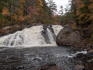
-Hill town line, the Smith River drops over Profile Falls and arrives at the Pemigewasset River.
U.S. Route 4
U.S. Route 4
U.S. Route 4 is a long United States highway that runs from East Greenbush, New York, in the west to Portsmouth, New Hampshire, in the east, traversing through Vermont.In New York, US 4 is signed north–south to reflect its alignment in the state...
follow the Smith River from its source to Danbury. NH-104
New Hampshire Route 104
New Hampshire Route 104 is a long secondary east–west highway in central New Hampshire. The highway runs from Danbury to Meredith on Lake Winnipesaukee in the Lakes Region....
follows the river from Danbury to the east side of Alexandria.