

Sleeping Warrior
Encyclopedia
Isle of Arran
Arran or the Isle of Arran is the largest island in the Firth of Clyde, Scotland, and with an area of is the seventh largest Scottish island. It is in the unitary council area of North Ayrshire and the 2001 census had a resident population of 5,058...
hills as seen from the Ayrshire
Ayrshire
Ayrshire is a registration county, and former administrative county in south-west Scotland, United Kingdom, located on the shores of the Firth of Clyde. Its principal towns include Ayr, Kilmarnock and Irvine. The town of Troon on the coast has hosted the British Open Golf Championship twice in the...
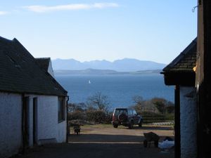
coast. It is a well-known sight that takes its name from a resemblance to a resting human figure. Various interpretations of the profile exist although the view of A' Chìr and Caisteal Abhail
Caisteal Abhail
Caisteal Abhail is a mountain on the Isle of Arran in Scotland.It is the northernmost Corbett on the island. The mountain forms the main part of a view known as The Sleeping Warrior due to its distinctive outline as seen from the mainland...
from North Ayrshire
North Ayrshire
North Ayrshire is one of 32 council areas in Scotland with a population of roughly 136,000 people. It is located in the south-west region of Scotland, and borders the areas of Inverclyde to the north, Renfrewshire to the north-east and East Ayrshire and South Ayrshire to the East and South...
and Bute
Isle of Bute
Bute is an island in the Firth of Clyde in Scotland. Formerly part of the county of Buteshire, it now constitutes part of the council area of Argyll and Bute. Its resident population was 7,228 in April 2001.-Geography:...
is arguably the most convincing.
Interpretations
Although the idea is well known the specific hills involved are variously described. Keay & Keay (1994) refer to "the profile of the 'Sleeping Warrior' of Arran as seen from the Clyde Coast", suggesting that several hills are included. However, various websites claim the phrase refers to single hills, none of which individually resemble a reclining human figure, or to different parts of the north Arran range.One interpretation is that all the hills north of Brodick on the island of Arran's west coast are profiled, including Goat Fell
Goat Fell
Goat Fell is the highest point on the Isle of Arran. At 874 metres , it is one of four Corbetts on the island...
, Caisteal Abhail
Caisteal Abhail
Caisteal Abhail is a mountain on the Isle of Arran in Scotland.It is the northernmost Corbett on the island. The mountain forms the main part of a view known as The Sleeping Warrior due to its distinctive outline as seen from the mainland...
and Cìr Mhòr
Cìr Mhòr
Cìr Mhòr is a Corbett known as the Matterhorn of Arran. Its name means the "big comb", referring its resemblance to a cockscomb. It is separated from the island's highest peak, Goat Fell by a col called The Saddle...
. This view could resemble "the outline of a warrior lying on his back with his hands across his chest" although the individual features are vague and there is no obvious head. As other sources confirm, the Warrior does not include Goat Fell
Goat Fell
Goat Fell is the highest point on the Isle of Arran. At 874 metres , it is one of four Corbetts on the island...
. High Spicer, for example writes: "And in broken weather the clouds would lie like a dingy blanket upon the heights until the wind blew them over, or the sun pierced them, and revealed the spire of Goatfell or the majestic figure of the Sleeping Warrior."
Caisteal Abhail itself is sometimes claimed as the sole inspiration, although there is no view of this Corbett alone that seems to specifically evoke the image.
Similar claims are sometimes made for other views such as Caisteal Abhail and A' Chìr ridge (between Cìr Mhòr and Beinn Tarsuinn), that clearly suggests a humanoid head and shoulders (although no torso) or the rather less compelling Beinn Nuis and Beinn Tarsuinn
Beinn Tarsuinn (Corbett)
Beinn Tarsuinn is a mountain on the Isle of Arran, Scotland. It is the southernmost of the four Corbetts on the island, lying between Glen Rosa to the east and Glen Iorsa to the west....
ridges, that are not visible from the Ayrshire coast.
However, as the view from St Ninian's Bay on Bute indicates the full profile begins with A' Chìr ridge "face", includes Caisteal Abhail as the folded arms and continues along the ridge towards Meall Mòr in the direction of Lochranza
Lochranza
Lochranza is a village located on the Isle of Arran in the Firth of Clyde, Scotland. The population, somewhat in decline, is around 200 people....
and Catacol
Catacol
Catacol is a small village on the Isle of Arran, Scotland. It is located on the north west side of the island, just a few miles along the coastal road from Lochranza at the foot of Glen Catacol, a steep-sided valley. It derives its name from Old Norse, referring to the 'gully of the...
. Once seen in greater detail from the direction of the North Ayrshire coast, the full profile becomes clear.