
Skeyton
Encyclopedia
Skeyton is a village and a civil parish
in the English
county of Norfolk
. The village is 13.5 miles (21.7 km) south of Cromer
, 13.4 miles (21.6 km) north of Norwich
and 129 miles (207.6 km) north-east of London
. The village lies 4 miles (6.4 km) east of the nearby town of Aylsham
. The nearest railway station is at North Walsham
for the Bittern Line
which runs between Sheringham
, Cromer and Norwich. The nearest airport is Norwich International Airport
. The Village and parish of Skeyton had in the 2001 census
, a population of 200
For the purposes of local government, the parish falls within the district
of North Norfolk
.
. The adjoining parishes along this western boundary are, north to south, Felmingham
CP, Burgh and Tuttington
CP and Buxton
with Lammas
CP. To the north the parish is along the southern edge of woodland called North Walsham wood and Lord Anson’s Wood, both of which are in the parish of North Walsham
. The eastern boundary is with the parish of Swanton Abbott
. The village derives its name from the Old English name meaning Skeggi’s Farm.
windows are 15th century replacements. The church once had a north aisle which was removed in the 15th century to widen the church which accounts to the asymmetric position of the Church tower. The uncrenellated tower is a simple square design with carstone quoins. Inside the church the 19th century kingpost roof is visible, but older arched braces survive above the site of the rood screen. This was one of the first Norfolk churches to replace its box pews for benches and these survive along with an elaborate font and cover dating to 1846. Also of note is the plaster cast Royal Arms of Victoria
to commemorate Queen Victoria's Jubilee in 1887, which are painted and gilt
and survive in fine condition.
Civil parish
In England, a civil parish is a territorial designation and, where they are found, the lowest tier of local government below districts and counties...
in the English
England
England is a country that is part of the United Kingdom. It shares land borders with Scotland to the north and Wales to the west; the Irish Sea is to the north west, the Celtic Sea to the south west, with the North Sea to the east and the English Channel to the south separating it from continental...
county of Norfolk
Norfolk
Norfolk is a low-lying county in the East of England. It has borders with Lincolnshire to the west, Cambridgeshire to the west and southwest and Suffolk to the south. Its northern and eastern boundaries are the North Sea coast and to the north-west the county is bordered by The Wash. The county...
. The village is 13.5 miles (21.7 km) south of Cromer
Cromer
Cromer is a coastal town and civil parish in north Norfolk, England. The local government authority is North Norfolk District Council, whose headquarters is in Holt Road in the town. The town is situated 23 miles north of the county town, Norwich, and is 4 miles east of Sheringham...
, 13.4 miles (21.6 km) north of Norwich
Norwich
Norwich is a city in England. It is the regional administrative centre and county town of Norfolk. During the 11th century, Norwich was the largest city in England after London, and one of the most important places in the kingdom...
and 129 miles (207.6 km) north-east of London
London
London is the capital city of :England and the :United Kingdom, the largest metropolitan area in the United Kingdom, and the largest urban zone in the European Union by most measures. Located on the River Thames, London has been a major settlement for two millennia, its history going back to its...
. The village lies 4 miles (6.4 km) east of the nearby town of Aylsham
Aylsham
Aylsham is a historic market town and civil parish on the River Bure in north Norfolk, England, about north of Norwich. The river rises near Melton Constable, upstream from Aylsham and continues to Great Yarmouth and the North Sea, although it was only made navigable after 1779, allowing grain,...
. The nearest railway station is at North Walsham
North Walsham railway station
North Walsham is a railway station in the town of North Walsham in the English county of Norfolk. The station is served by local services operated by National Express East Anglia on the Bittern Line from Norwich to Cromer and Sheringham...
for the Bittern Line
Bittern Line
The Bittern Line is a railway line from Norwich to Cromer then Sheringham in Norfolk, England. It is one of the most scenic in the East of England traversing the Norfolk Broads on its route to the Area of Outstanding Natural Beauty on the North Norfolk Coast. The line is part of the Network Rail...
which runs between Sheringham
Sheringham
Sheringham is a seaside town in Norfolk, England, west of Cromer.The motto of the town, granted in 1953 to the Sheringham Urban District Council, is Mare Ditat Pinusque Decorat, Latin for "The sea enriches and the pine adorns"....
, Cromer and Norwich. The nearest airport is Norwich International Airport
Norwich International Airport
Norwich International Airport , also known as Norwich Airport, is an airport in the City of Norwich within Norfolk, England north of the city centre and on the edge of the city's suburbs....
. The Village and parish of Skeyton had in the 2001 census
United Kingdom Census 2001
A nationwide census, known as Census 2001, was conducted in the United Kingdom on Sunday, 29 April 2001. This was the 20th UK Census and recorded a resident population of 58,789,194....
, a population of 200
For the purposes of local government, the parish falls within the district
Non-metropolitan district
Non-metropolitan districts, or colloquially shire districts, are a type of local government district in England. As created, they are sub-divisions of non-metropolitan counties in a so-called "two-tier" arrangement...
of North Norfolk
North Norfolk
North Norfolk is a local government district in Norfolk, United Kingdom. Its council is based in Cromer. The council headquarters can be found approximately out of the town of Cromer on the Holt Road.-History:...
.
Description
The parish of Skeyton is in the District of North Norfolk and covers an area of 528 hectares (1,304.7 acre). The western boundary of the parish runs along the course of two streams or Becks, Skeyton Beck along the north-west boundary and Kings Beck to the south-west to the point where the Beck joins the River BureRiver Bure
The River Bure is a river in the county of Norfolk, England, most of it in The Broads. The Bure rises near Melton Constable, upstream of Aylsham, which was the original head of navigation. Nowadays, the head of navigation is downstream at Coltishall Bridge...
. The adjoining parishes along this western boundary are, north to south, Felmingham
Felmingham
Felmingham is a village and civil parish in the English county of Norfolk.It covers an area of and had a population of 564 in 218 households as of the 2001 census.For the purposes of local government, it falls within the district of North Norfolk....
CP, Burgh and Tuttington
Tuttington
Tuttington is a village is located in the civil parish of Burgh and Tuttington, in the English county of Norfolk. The village is 11.1 miles south of Cromer, 15 miles north of Norwich and 129 miles north-east of London. The village lies 3 miles east of the nearby town of Aylsham...
CP and Buxton
Buxton, Norfolk
Buxton is a village in Norfolk, located between Norwich and Aylsham. The village is mentioned in the Domesday Book of 1085. Buxton is adjacent to the village of Lammas. The two villages are separated by the River Bure at Buxton Mill but are otherwise indistinguishable...
with Lammas
Buxton Lammas
Buxton with Lammas is a civil parish in Broadland in the English county of Norfolk. It comprises the villages of Buxton lying to the west of the River Bure and Lammas on the eastern side of the river. At this point the River Bure is crossed by the Bure Valley Railway on a long girder bridge. ...
CP. To the north the parish is along the southern edge of woodland called North Walsham wood and Lord Anson’s Wood, both of which are in the parish of North Walsham
North Walsham
North Walsham is a market town and civil parish in Norfolk, England in the North Norfolk district.-Demographics:The civil parish has an area of and in the 2001 census had a population of 11,998. For the purposes of local government, the parish falls within the district of North...
. The eastern boundary is with the parish of Swanton Abbott
Swanton Abbott
Swanton Abbott civil parish has an area of and in the 2001 census had a population of 436 in 167 households. For the purposes of local government, the parish falls within the district of North Norfolk....
. The village derives its name from the Old English name meaning Skeggi’s Farm.
History
There is little evidence to suggest evidence of settlement or activity in this parish much until the medieval period. Archeological finds in the parish before this period include small amounts of Bronze Age artifacts, Roman objects including an unusual Roman figurine of the Ancient Egyptian goddess Isis suckling the infant Horus, although it was fairly badly corroded and had several pieces missing. A scatter of metalwork objects from the Saxon period have been found in the parish, many of which are typical objects from this era. These items include several brooches, a delicate silver belt loop and Late Saxon Thetford Ware pottery shreds. Most of this material has been uncovered in the vicinity of the church.Norman Period
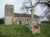
Neither the village or the parish are mentioned in the Domesday Book of 1086. It has not been established if Skeyton had existed at this time or was too small to merit a mention. Alternatively it may have been included, but not named, as a part of one of the surrounding parishes.The parish church of All Saints
The parish church of All Saints is situated on prominent upland surrounded by fields with just one dwelling near-by. The church dates to the 13th century although the south porch dates to the 14th century. The wood door has a fine example of an Iron door knocker. To the side of the porch one of the Lancet windows has been blocked up. Most of the naveNave
In Romanesque and Gothic Christian abbey, cathedral basilica and church architecture, the nave is the central approach to the high altar, the main body of the church. "Nave" was probably suggested by the keel shape of its vaulting...
windows are 15th century replacements. The church once had a north aisle which was removed in the 15th century to widen the church which accounts to the asymmetric position of the Church tower. The uncrenellated tower is a simple square design with carstone quoins. Inside the church the 19th century kingpost roof is visible, but older arched braces survive above the site of the rood screen. This was one of the first Norfolk churches to replace its box pews for benches and these survive along with an elaborate font and cover dating to 1846. Also of note is the plaster cast Royal Arms of Victoria
Victoria of the United Kingdom
Victoria was the monarch of the United Kingdom of Great Britain and Ireland from 20 June 1837 until her death. From 1 May 1876, she used the additional title of Empress of India....
to commemorate Queen Victoria's Jubilee in 1887, which are painted and gilt
Gilding
The term gilding covers a number of decorative techniques for applying fine gold leaf or powder to solid surfaces such as wood, stone, or metal to give a thin coating of gold. A gilded object is described as "gilt"...
and survive in fine condition.