
Six Foot Track
Encyclopedia
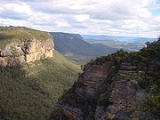
The Six Foot Track was originally a bridle trail from Katoomba
(New South Wales
, Australia
) to the Jenolan Caves
, and is now a walking trail of 44.3 kilometres.
in 1870, the journey involved a lengthy horse ride from the nearest station at Tarana
.
In 1884 a New South Wales government party marked out a new horse track from Katoomba across the Coxs River to shorten the journey. The track was constructed to be six feet wide (in order that two loaded drays could pass each other at any point), and was completed at a cost of 2500 pounds, although it was not until 1937 that the track became known as the Six Foot Track, by which time it was already close to impassable.
The first recorded journey on the track was in 1887 by the NSW Governor
, Lord Carrington
, and his wife. The journey from start to finish took approximately eight hours and was very popular until motor vehicles gradually took over in the twentieth century, and an alternate route to Jenolan was built.
floor. Here in the valley the track passes the historical site of the abandoned shale mining Megalong Village and continues on through farmland past the Megalong Cemetery (this is just off the track).
The track winds along the steep-sided banks of the Coxs River. The river is crossed either via ford or by using a suspension bridge, called Bowtells Swing Bridge, built by 3 Troop, the 'Tunnel Rats' of the 1st Field Squadron of the Royal Australian Engineers
in 1991. It was named in honour of CPL Bob Bowtell a former member of 3 Tp. Bob was born in Katoomba and he died in Vietnam. He was one of the famous 'Tunnel Rats' and he died in a tunnel clearance. His children attended the opening of the bridge in 1992.
A dedicated campsite is available where most people camp the night before the demanding climb up to Mini-Mini Saddle the next morning and then the descent to Alum Creek.
Another challenging uphill climb is then tackled with the rise to the Pluviometer which is situated towards the eastern end of the Black Range ridge. This is followed by a slightly-inclining walk along the ridgeline to the dedicated Black Range Campsite. From here the track crosses then hugs close to Jenolan Road before diverting to the final descent to the limestone caves at Jenolan.
The track is best walked in spring or autumn due to the heat and bushfire hazards of summer and the cold nights and rain of winter. The track can be walked in either direction.
There is a popular running race, the Six Foot Track Marathon, along the length of the trail every March. In 2009, 849 runners started the race at Explorers Tree. This race has become iconic, one of the premier long distance events in the world and celebrated its 25th anniversary on March 8, 2008.
Relevant topographic maps for the track are available from the NSW Department of Lands, maps Katoomba (8930-1S), Hampton (8930-4S) and Jenolan (8930-3N) cover the entirety of the track. Or Download and print the full map set on the PDF from wildwalks
Katoomba, New South Wales
Katoomba is the chief town of the City of Blue Mountains in New South Wales, Australia and the administrative headquarters of Blue Mountains City Council. It is on the Great Western Highway 110 kilometres west of Sydney and 39 kilometres south-east of Lithgow. Katoomba railway station is on the...
(New South Wales
New South Wales
New South Wales is a state of :Australia, located in the east of the country. It is bordered by Queensland, Victoria and South Australia to the north, south and west respectively. To the east, the state is bordered by the Tasman Sea, which forms part of the Pacific Ocean. New South Wales...
, Australia
Australia
Australia , officially the Commonwealth of Australia, is a country in the Southern Hemisphere comprising the mainland of the Australian continent, the island of Tasmania, and numerous smaller islands in the Indian and Pacific Oceans. It is the world's sixth-largest country by total area...
) to the Jenolan Caves
Jenolan Caves
The Jenolan Caves are caves in the Blue Mountains, New South Wales, Australia; 175 kilometres west of Sydney. They are the most celebrated of several similar groups in the limestone of the country being the oldest discovered open caves in the world...
, and is now a walking trail of 44.3 kilometres.
History
The Jenolan Caves are a tourist attraction that first became popular in the mid and late nineteenth century. The journey to the caves from Sydney was a long one, though, and even after the western railway was completed to BathurstBathurst, New South Wales
-CBD and suburbs:Bathurst's CBD is located on William, George, Howick, Russell, and Durham Streets. The CBD is approximately 25 hectares and surrounds two city blocks. Within this block layout is banking, government services, shopping centres, retail shops, a park* and monuments...
in 1870, the journey involved a lengthy horse ride from the nearest station at Tarana
Tarana, New South Wales
Tarana is a small town in the Central West of New South Wales, Australia in the City of Lithgow.It is the former junction of the Oberon Branch railway with the Main Western Line. This branch line was notable for its steep 1 in 30 gradients and sharp 100 m curves. This little station could be...
.
In 1884 a New South Wales government party marked out a new horse track from Katoomba across the Coxs River to shorten the journey. The track was constructed to be six feet wide (in order that two loaded drays could pass each other at any point), and was completed at a cost of 2500 pounds, although it was not until 1937 that the track became known as the Six Foot Track, by which time it was already close to impassable.
The first recorded journey on the track was in 1887 by the NSW Governor
Governors of New South Wales
The Governor of New South Wales is the state viceregal representative of the Australian monarch, Queen Elizabeth II, who is equally shared with 15 other sovereign nations in a form of personal union, as well as with the eleven other jurisdictions of Australia, and resides predominantly in her...
, Lord Carrington
Robert Wynn Carrington, 1st Marquess of Lincolnshire
Charles Robert Wynn-Carrington, 1st Marquess of Lincolnshire KG, GCMG, PC, DL, JP , known as the Lord Carrington from 1868 to 1895 and as the Earl Carrington from 1895 to 1912, was a British Liberal politician and aristocrat.-Background and education:Born at Whitehall, London, Lincolnshire was the...
, and his wife. The journey from start to finish took approximately eight hours and was very popular until motor vehicles gradually took over in the twentieth century, and an alternate route to Jenolan was built.
Track Description
Starting on the western outskirts of Katoomba at the Explorers Tree, the track descends via steep steps through the temperate rainforest of Nellies Glen to the Megalong ValleyMegalong Valley
The Megalong Valley is part of the Blue Mountains of New South Wales, Australia. It is located west of Katoomba. On its eastern side, the valley is separated from the Jamison Valley by Narrow Neck Plateau. The Shipley Plateau overlooks part of the valley....
floor. Here in the valley the track passes the historical site of the abandoned shale mining Megalong Village and continues on through farmland past the Megalong Cemetery (this is just off the track).
The track winds along the steep-sided banks of the Coxs River. The river is crossed either via ford or by using a suspension bridge, called Bowtells Swing Bridge, built by 3 Troop, the 'Tunnel Rats' of the 1st Field Squadron of the Royal Australian Engineers
Royal Australian Engineers
The Royal Australian Engineers is a corps of the Australian Army . The RAE is ranked fourth in seniority of the corps of the Australian Army, behind the Staff Cadets, Armoured and Artillery Corps...
in 1991. It was named in honour of CPL Bob Bowtell a former member of 3 Tp. Bob was born in Katoomba and he died in Vietnam. He was one of the famous 'Tunnel Rats' and he died in a tunnel clearance. His children attended the opening of the bridge in 1992.
A dedicated campsite is available where most people camp the night before the demanding climb up to Mini-Mini Saddle the next morning and then the descent to Alum Creek.
Another challenging uphill climb is then tackled with the rise to the Pluviometer which is situated towards the eastern end of the Black Range ridge. This is followed by a slightly-inclining walk along the ridgeline to the dedicated Black Range Campsite. From here the track crosses then hugs close to Jenolan Road before diverting to the final descent to the limestone caves at Jenolan.
The track is best walked in spring or autumn due to the heat and bushfire hazards of summer and the cold nights and rain of winter. The track can be walked in either direction.
There is a popular running race, the Six Foot Track Marathon, along the length of the trail every March. In 2009, 849 runners started the race at Explorers Tree. This race has become iconic, one of the premier long distance events in the world and celebrated its 25th anniversary on March 8, 2008.
Relevant topographic maps for the track are available from the NSW Department of Lands, maps Katoomba (8930-1S), Hampton (8930-4S) and Jenolan (8930-3N) cover the entirety of the track. Or Download and print the full map set on the PDF from wildwalks