
Shire of Yalgoo
Encyclopedia
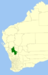
The Shire of Yalgoo is a Local Government Area
in the Mid West region of Western Australia
, about 500 kilometres (311 mi) north of the state capital, Perth
. The Shire covers an area of 28215 square kilometres (10,894 sq mi), and its seat of government is the town of Yalgoo
.
in August 1911. The Upper Murchison Road Board, gazetted in 1907, was renamed to Yalgoo in 1912. On 1 July 1961, it became a Shire Council following changes to the Local Government Act.
Local Government Areas of Western Australia
The Australian state of Western Australia is divided into 141 local government areas...
in the Mid West region of Western Australia
Western Australia
Western Australia is a state of Australia, occupying the entire western third of the Australian continent. It is bounded by the Indian Ocean to the north and west, the Great Australian Bight and Indian Ocean to the south, the Northern Territory to the north-east and South Australia to the south-east...
, about 500 kilometres (311 mi) north of the state capital, Perth
Perth, Western Australia
Perth is the capital and largest city of the Australian state of Western Australia and the fourth most populous city in Australia. The Perth metropolitan area has an estimated population of almost 1,700,000....
. The Shire covers an area of 28215 square kilometres (10,894 sq mi), and its seat of government is the town of Yalgoo
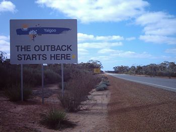
Yalgoo, Western Australia
-Further reading:* Palmer, Alex. Yalgoo Fremantle, W.A: Lap Industries. ISBN 0959058400- See also :* Yalgoo - the ecological region* Thundelarra* Shire of Yalgoo - the local government region...
.
History
The original Yalgoo Road Board was gazetted in 1896, and merged with the Shire of MullewaShire of Mullewa
The Shire of Mullewa was a Local Government Area in the Mid West region of Western Australia, about east of the city of Geraldton and about north of the state capital, Perth. The Shire covered an area of , and its seat of government was the town of Mullewa...
in August 1911. The Upper Murchison Road Board, gazetted in 1907, was renamed to Yalgoo in 1912. On 1 July 1961, it became a Shire Council following changes to the Local Government Act.
Towns and localities
- YalgooYalgoo, Western Australia-Further reading:* Palmer, Alex. Yalgoo Fremantle, W.A: Lap Industries. ISBN 0959058400- See also :* Yalgoo - the ecological region* Thundelarra* Shire of Yalgoo - the local government region...
- Gullewa
- Noongal
- Paynes FindPaynes Find, Western AustraliaPaynes Find is a former gold rush settlement approximately northeast of Perth in the Mid West region of Western Australia. It is reachable by the Great Northern Highway. Only a roadhouse, which serves as a fuel stop, and a few other buildings remain today. The area is renowned for its...
Pastoral Station names associated with Yalgoo
Note that some of these stations may lie outside of the local government boundary.- Barnong
- Bunnawarra
- Carlaminda
- Dalgaranga
- Edah
- Gabyon
- Jingemarra
- Maranalgo
- Meka
- Melangata
- Mellenbye
- Mount Gibson
- Muralgarra
- Nalbarra
- Ninghan
- Noongal
- Oudabunna
- Thundelarra
- Wagga Wagga
- Wydgee
See also
- Yalgoo, Western AustraliaYalgoo, Western Australia-Further reading:* Palmer, Alex. Yalgoo Fremantle, W.A: Lap Industries. ISBN 0959058400- See also :* Yalgoo - the ecological region* Thundelarra* Shire of Yalgoo - the local government region...
- the locality - Yalgoo (biogeographic region)Yalgoo (biogeographic region)Yalgoo is an Interim Biogeographic Regionalisation for Australia region in Western Australia and part of the larger Southwest Australia savanna ecoregion.In the IBRA system it has the code of , and it has two sub-regions:...
- the ecological region