
Shire of Tammin
Encyclopedia
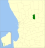
The Shire of Tammin is a Local Government Area
located in the Wheatbelt region of Western Australia
. Its seat of government is the town of Tammin
, about 80 kilometres (50 mi) west of Merredin
and about 180 kilometres (112 mi) east of Perth
, the state capital.
). In 1948, the Tammin Road Board was gazetted, and on 1 July 1961, it became a Shire Council following changes to the Local Government Act.
Local Government Areas of Western Australia
The Australian state of Western Australia is divided into 141 local government areas...
located in the Wheatbelt region of Western Australia
Western Australia
Western Australia is a state of Australia, occupying the entire western third of the Australian continent. It is bounded by the Indian Ocean to the north and west, the Great Australian Bight and Indian Ocean to the south, the Northern Territory to the north-east and South Australia to the south-east...
. Its seat of government is the town of Tammin
Tammin, Western Australia
The town of Tammin is located in the central agricultural region, east of Perth, Western Australia and midway between the towns of Cunderdin and Kellerberrin on the Great Eastern Highway.-History:...
, about 80 kilometres (50 mi) west of Merredin
Merredin, Western Australia
-Economy:The agricultural land around Merredin produces 40% of Western Australia’s wheat quota. As a focal point for the region, Merredin’s local bulk handling co-operative receives and processes in excess of a million tonnes of grain every year...
and about 180 kilometres (112 mi) east of Perth
Perth, Western Australia
Perth is the capital and largest city of the Australian state of Western Australia and the fourth most populous city in Australia. The Perth metropolitan area has an estimated population of almost 1,700,000....
, the state capital.
History
Originally the area was governed by the Meckering Road Board (now the neighbouring Shire of CunderdinShire of Cunderdin
The Shire of Cunderdin is a Local Government Area located in the Wheatbelt region of Western Australia, about west of Merredin and about east of Perth, the state capital. The Shire covers an area of and its seat of government is the town of Cunderdin....
). In 1948, the Tammin Road Board was gazetted, and on 1 July 1961, it became a Shire Council following changes to the Local Government Act.
Wards
The shire has never had wards, and all 6 councillors sit at large. The Shire President is elected from amongst the councillors.Towns and localities
- TamminTammin, Western AustraliaThe town of Tammin is located in the central agricultural region, east of Perth, Western Australia and midway between the towns of Cunderdin and Kellerberrin on the Great Eastern Highway.-History:...
- BungullaBungulla, Western AustraliaBungulla is a small town located on the Great Eastern Highway in the central Wheatbelt region of Western Australia.The town came into being as a railway station on the line to Merredin. Its name is Aboriginal in origin; the word Bun-Galla means the part of the body situated above the hips. The...
- Wyola
- YorkrakineYorkrakineYorkrakine is a small town in the Wheatbelt region of Western Australia, and is part of the Shire of Tammin, east of the state capital, Perth. At the 2006 census, Yorkrakine had a population of 117....