
Shire of Pingelly
Encyclopedia
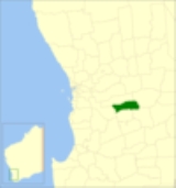
The Shire of Pingelly is a Local Government Area
in the Wheatbelt region of Western Australia
, about 160 kilometres (99 mi) southeast of the state capital, Perth
, between the Shires of Brookton
and Cuballing
along the Great Southern Highway
. The Shire covers an area of 1295 square kilometres (500 sq mi), and its seat of government is the town of Pingelly
.
The ward systems created under successive divisions were as follows:
Local Government Areas of Western Australia
The Australian state of Western Australia is divided into 141 local government areas...
in the Wheatbelt region of Western Australia
Western Australia
Western Australia is a state of Australia, occupying the entire western third of the Australian continent. It is bounded by the Indian Ocean to the north and west, the Great Australian Bight and Indian Ocean to the south, the Northern Territory to the north-east and South Australia to the south-east...
, about 160 kilometres (99 mi) southeast of the state capital, Perth
Perth, Western Australia
Perth is the capital and largest city of the Australian state of Western Australia and the fourth most populous city in Australia. The Perth metropolitan area has an estimated population of almost 1,700,000....
, between the Shires of Brookton
Shire of Brookton
The Shire of Brookton is a Local Government Area located in the Wheatbelt region of Western Australia, about southeast of Perth, the state capital...
and Cuballing
Shire of Cuballing
The Shire of Cuballing is a Local Government Area located in the Wheatbelt region of Western Australia, about north of the town of Narrogin and southeast of the capital, Perth. The Shire covers an area of and its seat of government is the small town of Cuballing.Over 10% of its area contains...
along the Great Southern Highway
Great Southern Highway
Great Southern Highway is a highway in the Southern Wheatbelt region of Western Australia, starting from Great Eastern Highway at The Lakes, 50 km from Perth, and ending at Albany Highway near Cranbrook. It is the primary thoroughfare for this part of Western Australia and runs parallel with the...
. The Shire covers an area of 1295 square kilometres (500 sq mi), and its seat of government is the town of Pingelly
Pingelly, Western Australia
Pingelly is a town and shire located in the Wheatbelt region of Western Australia, from Perth via the Brookton Highway and Great Southern Highway. The town is also located on the Great Southern railway line...
.
History
On 24 December 1891, the Morambine Road District was created. On 21 February 1913, it was renamed Pingelly. On 1 July 1961, it became a Shire following enactment of the Local Government Act 1960.Wards
From 20 October 2007, Pingelly is no longer divided into wards, and its 8 councillors represent the entire shire.The ward systems created under successive divisions were as follows:
| 1921 | 1986 | 1992 | 2003 |
|---|---|---|---|
| Pingelly Ward (3) | Pingelly Ward (4) | Town Ward (4) | |
| Central Ward (2) | Mourambine Ward (1) | Hotham Ward (1) | Hotham Ward (2) |
| Noonebin Ward (1) | Jingaring Ward (1) | Jingaring Ward (2) | |
| North East Ward (1) | Kulyaling Ward (1) | Kulyaling Ward (2) | |
| North West Ward (1) | Tutanning Ward (1) | Tutanning Ward (2) | |
| South East Ward (1) | |||
| South West Ward (1) | |||
Towns and localities
- PingellyPingelly, Western AustraliaPingelly is a town and shire located in the Wheatbelt region of Western Australia, from Perth via the Brookton Highway and Great Southern Highway. The town is also located on the Great Southern railway line...
- Boyagin
- DatteningDattening, Western AustraliaDattening is a small town located between Boddington and Pingelly in the Wheatbelt region of Western Australia.During the 1890s a farmer named Norris Taylor sunk a well in the locality and the area was initially known as Taylor's Well. By 1906 the local progress association petitioned for a...
- KulyalingKulyalling, Western AustraliaKulyalling or Kulyaling is a small town just off the Great Southern Highway located between Brookton and Pingelly in the Wheatbelt region of Western Australia....
- MoorumbineMoorumbine, Western AustraliaMoorumbine, also spelt Mourambine, is a small town located between Brookton and Pingelly in the Wheatbelt region of Western Australia.The area was first settled as a small agricultural community in the 1870s with an Anglican church, Saint Patricks, being built in 1873 at the expense of the local...
Population
| Year | Population |
|---|---|
| 1911 | 1,879 |
| 1921 | 1,644 |
| 1933 | 1,496 |
| 1947 | 1,230 |
| 1954 | 1,519 |
| 1961 | 1,639 |
| 1966 | 1,453 |
| 1971 | 1,447 |
| 1976 | 1,446 |
| 1981 | 1,410 |
| 1986 | 1,371 |
| 1991 | 1,171 |
| 1996 | 1,132 |
| 2001 | 1,122 |
| 2006 | 1,168 |